iGeo 1996, Теренна работа — Задача 6. Main research question
1996 iGeo – The Hague, The Netherlands The Fieldwork · 5 т.
Fieldwork: research questions and exercises
The fieldwork exercise in the Oranjezon area will be carried out along a transect. The observations will focus on soil, soil hydrology, geomorphology and vegetation/land use.
The research question should be answered after carrying out the exercises A E in the field and at the lab in the school in Oostkappelle.
In the field you will work in a multi national group of four. Each group will be provided with a map for every person and per group:
- a standard auger
- plastic bags for soil samples
- plastic bottles for water samples
- tables for soil description
- tables for vegetation description
- a sample card to determine soil colour
- a sample card to determine soil texture
Every group will be accompanied by one of the assistants of the organising committee who will act as an observer. The observer may only respond to questions regarding clarification of the fieldwork exercises.
During the fieldwork no contact between groups is allowed.
Upon arrival in the fieldwork area at Oranjezon a transect route will be assigned to you/your group. Walk inland from the coast line to the polder along the transect route that is assigned to your group. Observe the landscape and map the boundaries between the units. After the fieldwork you have to produce a map of the transect with a short description of the landscape units that you have found. Use the information about geomorphology, soil, hydrology and vegetation that you have gathered in the field (exercises A/E).
Условие
The structure of a typical coastal landscape
In general the beach can be divided into a zone with regular tidal influence and a higher part, inundated only when extreme high water levels occur. On this higher part of the beach some pioneer plants with high salt tolerance can settle. The dune landscape can be divided in: primary dunes, primary dune valleys and the dune complex. These morphological units have there own soil and vegetation characteristics (figure 7 + 8).
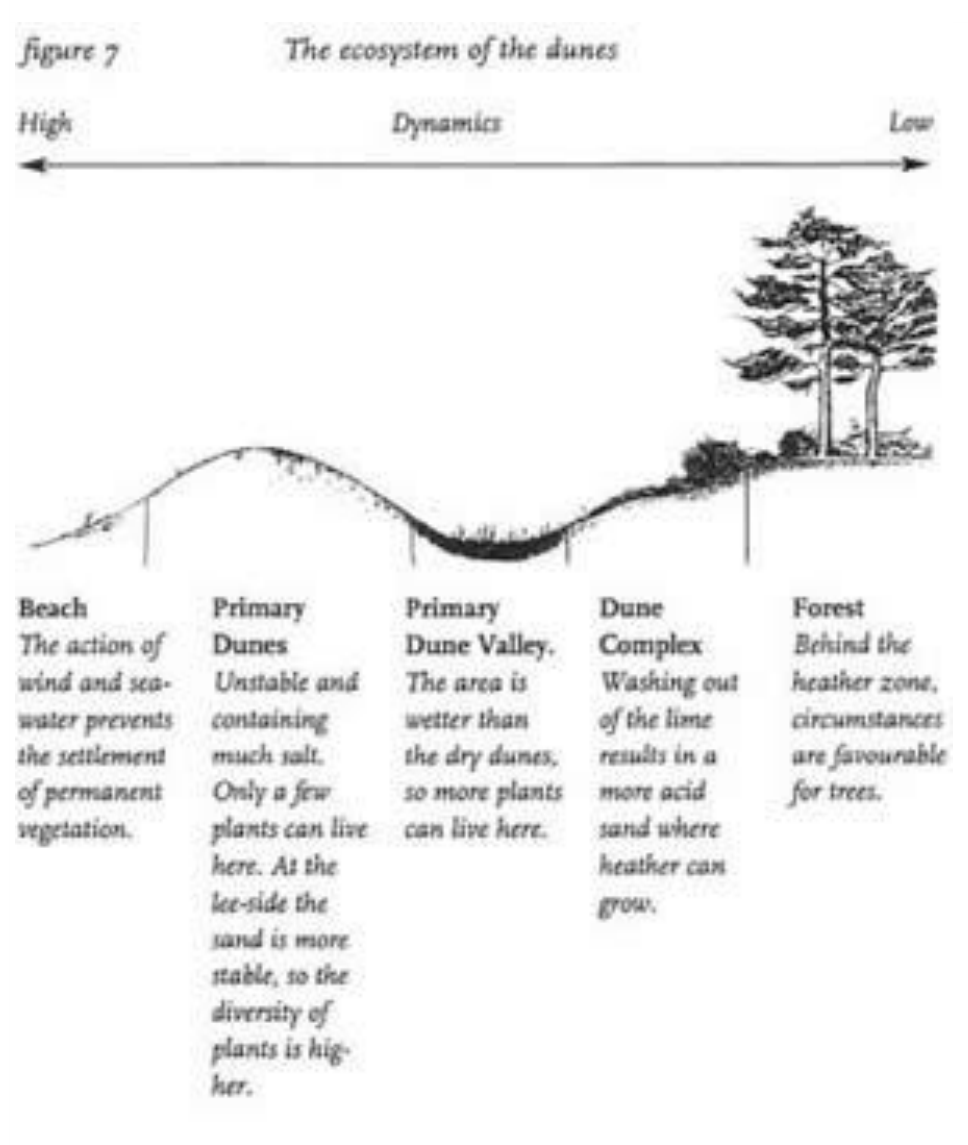
Nearby the sea the sediment contains lime, originating from fragmented shells. Therefore the plants near the coast line have a high lime tolerance. With increasing distance from the coast line the lime content is diminishing and other (secondary) plant species with a low lime tolerance can develop. In the older parts of the dune landscape even trees can thrive. The polder can not be divided into significant natural land units because it is entirely cultivated now.
The characteristics of a coastal landscape are summarised in figure 8.
| Landscape unit: | Morphology: | Soil: | Vegetation cover: |
|---|---|---|---|
| beach: tidal lands | flat | hydro-sand soil | bare |
| beach: dry | flat | hydro-sand soil | bare/almost bare |
| primary dunes | longitudinal hills | xero-sand soil | grasses |
| primary dune valleys | low depressions/ valleys | hydro-sand soil | grasses and shrubs |
| dune complex | complex of parabolic and dome shaped hills | hydro-sand soil | shrubs and trees |
| polder | flat with elevated ridge | hydro-clay soil | pastures and fields |
Fieldwork: research questions and exercises
The main research question is: To what extend the fieldwork area at Oranjezon is a typical coastal landscape? (compared with the typical coastal landscape as described in section 3 and figures 7 + 8). Give reasons for your answers and illustrate them with evidence from your fieldwork area.
Finally: answer the main question of the fieldwork exercise.
Решение
Внимание: Непълно решение
В архива няма официално решение на тази задача.
Report
Present your results in an in individual report with the following content: - Name - Number of the group/transect - Title of your report - Answers to all the exercises (A/E) - A map and a crossection of your transect, a description of the different land units in your transect - An answer to the main research question and your own conclusions.
The report may not exceed 5 pages. Aside from the map and the crosssection of your transect and the explanatory text the report may include graphs, tables, and additional maps that support your reasoning.
Acknowledgements
- de Jong, C. & ten Brinke, W.: Het Nederlandse Landschap, University of Nijmegen / ten Brinke, Meppel.
- Pannekoek, A.J. : Geologische Geschiedenis van Nederland, and 6 Staatdrukkerij, Den Haag, 1956.
- van der Borgt, M. : Grond onder je voeten, Centre for Environmental and 7 Education Zeeland, Goes, 1996.
Appendix II
Fragment of a Contour Line Map of Zeeland 1:5000, Nutsbedrijf Zeeland, Middelburg.
Appendix III — Marking scheme fieldwork
| Max | Aspect | Score |
|---|---|---|
| Results of the field research (19 marks): Answers to the main research question and the sub-questions: structure of the information, clarity and punctuality | ||
| 2 | Map | |
| 2 | Cross section. | |
| 2 | Other forms/graphs etc. | |
| 2 | Answer to subquestion A | |
| 2 | Answer to subquestion B | |
| 2 | Answer to subquestion C | |
| 2 | Answer to subquestion D | |
| 5 | Answer to the main question | |
| Level of performance (7 marks) | ||
| 3 | Level: relate results of fieldwork to the theory and own knowledge | |
| 2 | Creativity/originality | |
| 2 | Reflection: critical remarks about the exercises and the results, suggestions for improvement | |
| -2 | In case of insufficient contribution to group activities in the field | |
| Presentation (9 marks) | ||
| 3 | Text: title, structure of the text, the use of geographical concepts | |
| 2 | Visualisation: use of illustrations e.g. maps, drawings, graphics | |
| 2 | Appearance and lay-out | |
| 2 | Overall impression | |
| 35 | Maximum number of marks | |
| Total score |
Оригинал в Архива: 1996Fieldwork.pdf