iGeo 2015, Теренна работа — Задача 1.2. Starchonka river-valley cross-section, rock and its uses
Starchonka river-valley cross-section, rock and its uses · 4 т.
Missing grading transparency
The review describes a model profile and dark/light grey grading zones on a transparency. That transparency is not included in the archived task or six-page review. The complete printed description and task-specific marking criteria are retained; no replacement diagram is invented.
Условие
TIME LIMIT 30 MINUTES. 4 MARKS MAXIMUM
You are now just below Point B on the side of the Starchonka (Verkhnyaya Staritsa) river valley. Identify and explain the most common uses of the quarried rock that can be seen at the outcrop on the other side of the valley (west-southwest from you) by doing the following:
- using the template (1.2.1), draw a cross-section (profile) of the Starchonka river valley along the A-B line shown on the map provided in Fig.1,
- identify the rock (1.2.2) using drilling data from site A (Table.1),
- describe known uses of the rock identified in the table provided (1.2.3).
HINTS&TIPS
- To make sure you identify the correct outcrop, use your compasses.
- The vertical scale at the template 1.2.1 shows absolute height in metres.
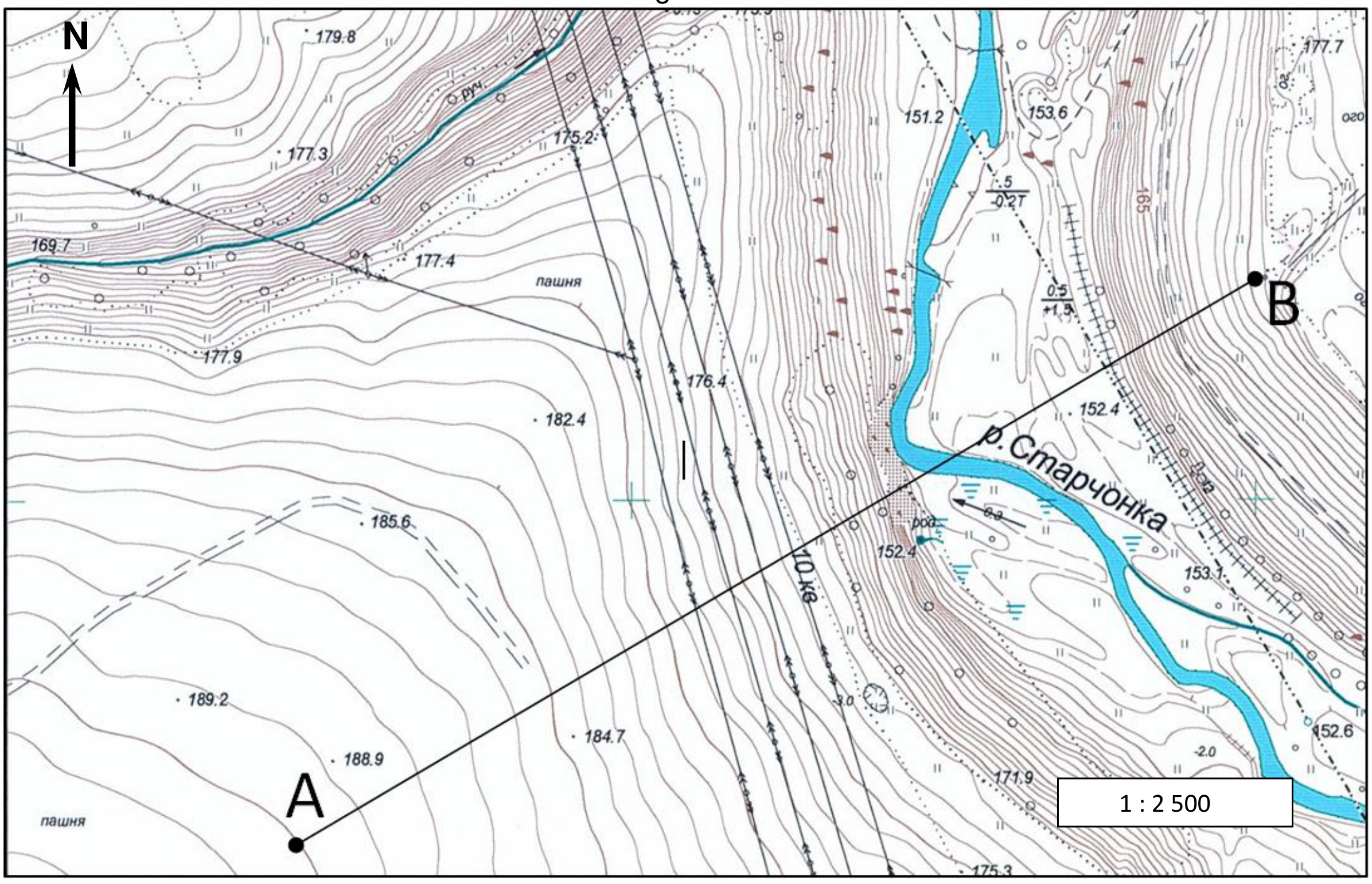
Table 1. Drilling data from site A
| Layers (from surface downwards) | Layer thickness, metres |
|---|---|
| soil and humus | 0.3 |
| dark-yellow clay with inclusions of boulder and pebble | 4.7 |
| dark-brown clay with inclusions of boulder and pebble | 10.0 |
| white limestone of various hardness | 52.0 |
1.2.1 Cross-section diagram
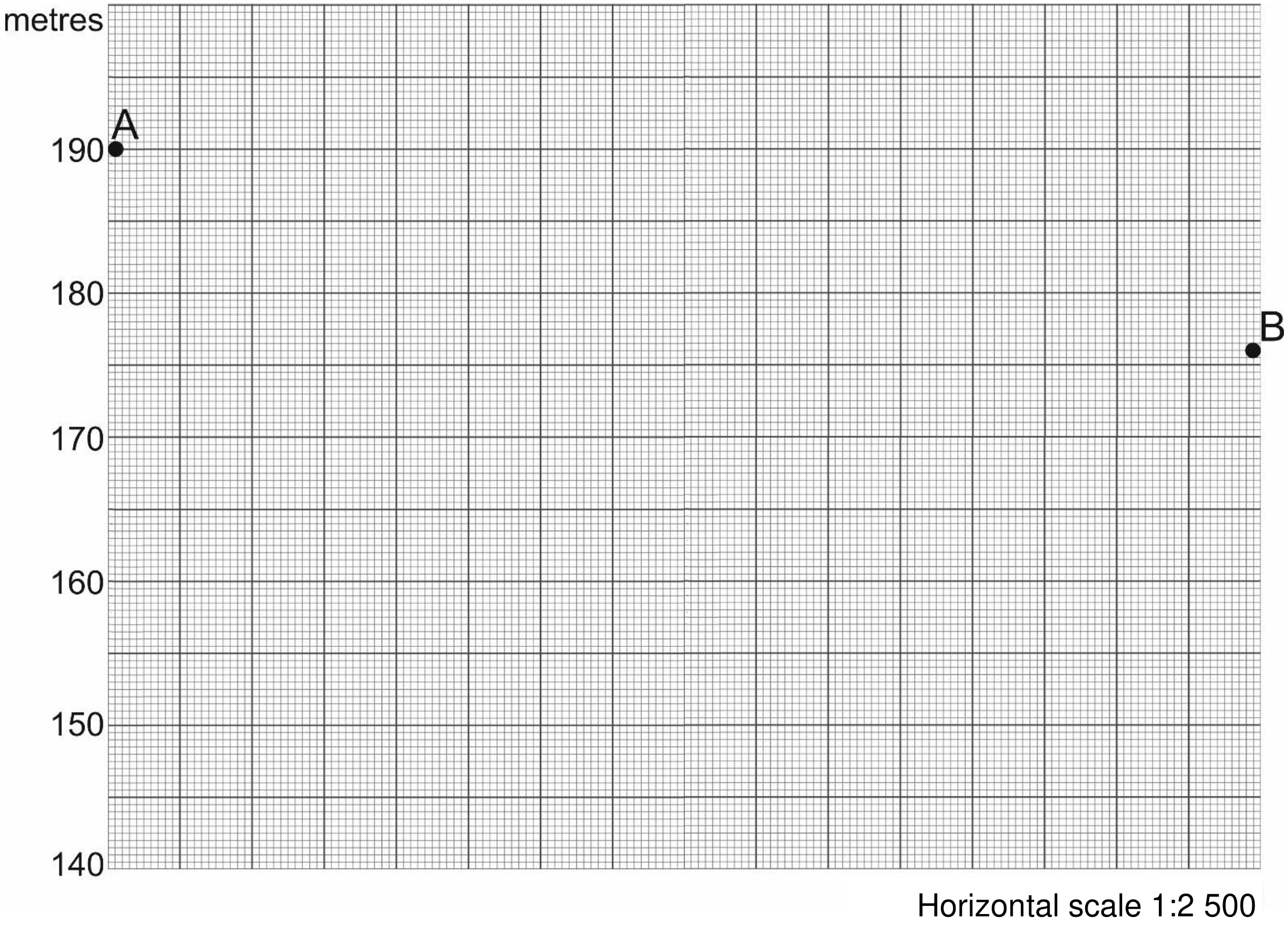
[2 т.]
1.2.2 The rock observed at the outcrop ____________________ [0,5 т.]
1.2.3 What are common uses of the identified rock? What industries use this rock? Describe how each of them uses this rock.
| Industries | Use of the rock |
|---|---|
[1,5 т.]
Отговори
- 1.2.2 limestone
Решение
Внимание: Непълно решение
The referenced expected-profile grading transparency and its grey tolerance zones are absent from the available source PDFs. Full task-specific prose and criteria are retained.
FWE1/2 required graphical skills in physical geography with the construction of a cross profile from observation and using a contour map of Moon Valley. The important part of the cross profile was a limestone outcrop, and students were asked to note the uses of this material. The wider importance of this exercise was to direct attention to the physical site characteristics of Staritsa.
FWE1/2 (marked out of 4)
Marking jury: Cornelia Fiscutean and Anu Brunila-Kovanen
The assessment used a transparency of the expected profile. 2 marks were available for the shape of the profile drawn. The shape of the profile we expected to see was asymmetric. ‘A’ was on the left hand side at 190m. Gradual slope down for first 150 metres (175m), before 20 metre steep section with a near vertical limestone face. The (alluvial) valley floor was at 150 metres elevation and was over 75m wide at this point. The steep eastern side of the valley was about 350m from the origin at about 165 metres elevation.
For marking, this profile was printed on a transparency, and the transparency was used to assign marks. There were two marks available for the profile. All of the profile within the dark grey zone – 2 marks. All of the profile within the light grey zone – 1 mark. Acceptable profile, but with part of profile outside both of the zones – 0.5 marks.
Identification of the rock as limestone 0.5 marks
1.5 marks are available for the identification of the uses of limestone. Each of the following would score .5. (a) house/church/civic building, (b) road/rail aggregate, (c) use in metallurgy (iron and glass making) and (d) use in agricultural lime (fertilizer).
Comments: generally quite well done. Perhaps the range required to be met for the full 2 marks on the profile was too tight, and this led to a lower mean than expected, but the lowest standard deviation.
Statistics
| Min | Max | Mean | Std |
|---|---|---|---|
| 0.0 | 3.5 | 1.74 | 0.77 |
Оригинал в Архива: 2015FWE1task2.pdf · решение от архива: 2015FWEMarking.pdf