iGeo 2017, Теренна работа, упражнение 1, задача 1A — Задача 1. Fieldwork Exercise 1 — Task 1A
14th International Geography Olympiad — FIELDWORK EXERCISE 1 — Task 1A · 7 т.
Условие
DURATION 60 MINUTES. TOTAL 7 MARKS
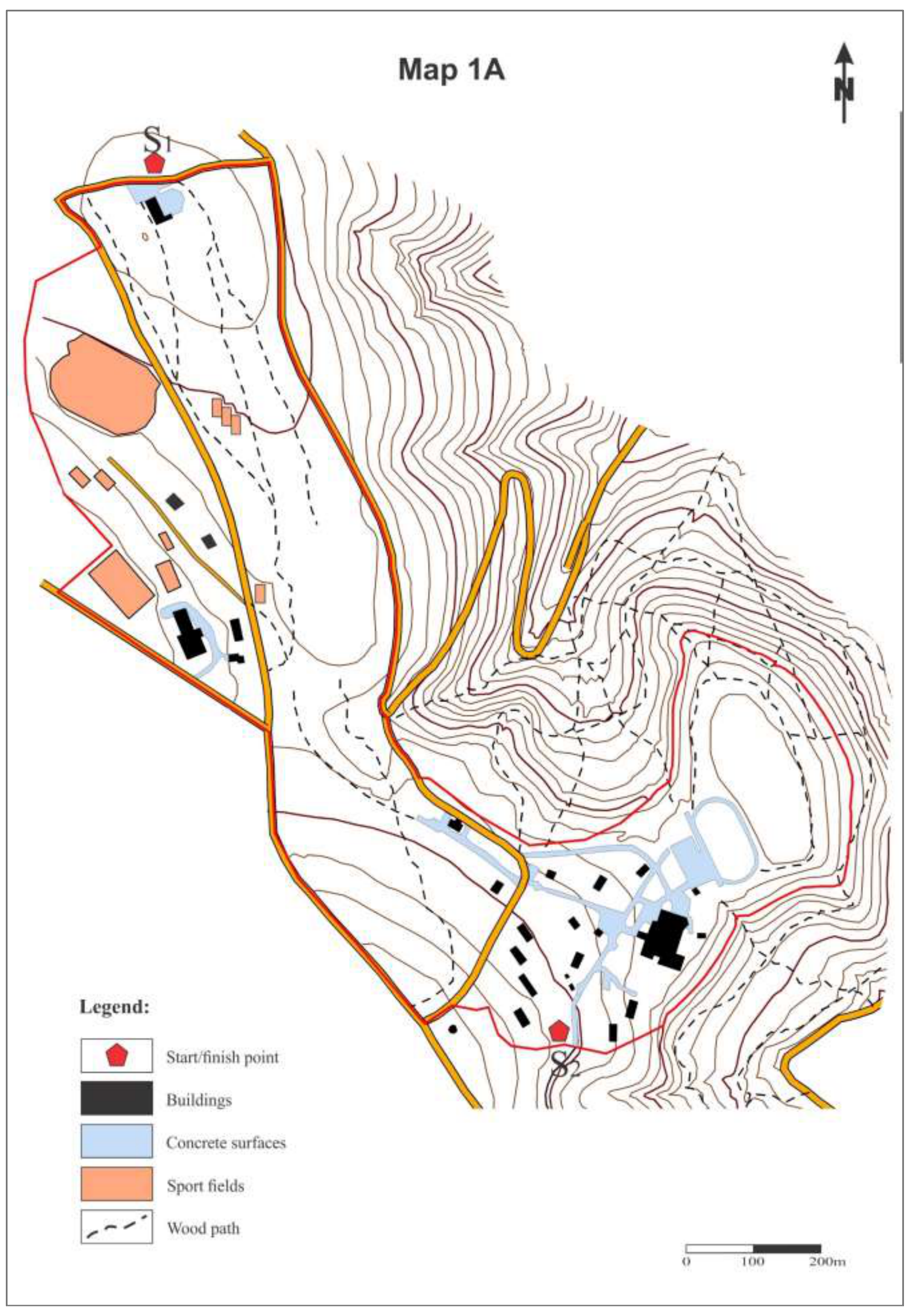
Walk from the start point S1 near the Golf restaurant to the Stop S2 at the Amphitheater on the eastern part of Pioneer City.
On your way, identify all of the following features, located within the zone, circled on Map 1A by a RED LINE:
- open air sports facilities,
- children playgrounds,
- buildings.
On Map 1A, identify and label with numbers the features which are already mapped. You will also see features which are not indicated on the map. Draw and label those features on the map, ensuring you label each with a number. Use only a pen (blue, black, or other color, if needed)!
Write down the numbers of all these features in the table on the response sheet and provide the following data for them:
- For all open air features, including sports facilities, report the purpose of use and estimate the maximum number of users (players, watchers, visitors) at noon (12:00) on a weekend summer sunny day.
- For buildings, report the condition (quality; see example below).
Building condition (quality) assessment – 4 classes maximum:
A – totally ruined, need to be rebuilt;
B – very poor, need to be completely repaired;
C – average, serious restoration needed;
D – good, no or minor repairs needed.
At the Stop S2 you will have 10 minutes to complete Map 1A and Response sheet before handing them in to the Jury.
Do not forget to write your student number on the cover sheet, map and the response sheet!
Assume that tennis is played in pairs (2 x 2), and there are 11 players in each football (soccer) team, 6 players in each volleyball team, and 5 players in basketball team (e.g. 10 players per game).
Task 1A RESPONSE SHEET
| Object No | Purpose of use, e.g. kind of sports | Condition/quality, A—D (buildings only) | Capacity of open air facilities, user numbers |
|---|---|---|---|
| 1. | |||
| 2. | |||
| 3. | |||
| 4. | |||
| 5. | |||
| 6. | |||
| 7. | |||
| 8. | |||
| 9. | |||
| 10. | |||
| 11. | |||
| 12. | |||
| 13. | |||
| 14. | |||
| 15. | |||
| 16. | |||
| 17. | |||
| 18. | |||
| 19. | |||
| 20. | |||
| Total users capacity at 12:00 |
Решение
Внимание: Непълно решение
В архива няма официално решение на тази задача.
Оригинал в Архива: FIELDWORK 1 TASK 1A.pdf