iGeo 2017, Теренна работа, упражнение 1, задача 1B — Задача 1. Task 1B
14th International Geography Olympiad — FIELDWORK EXERCISE 1 — Task 1B · 7 т.
Условие
DURATION 60 MINUTES. TOTAL 7 MARKS
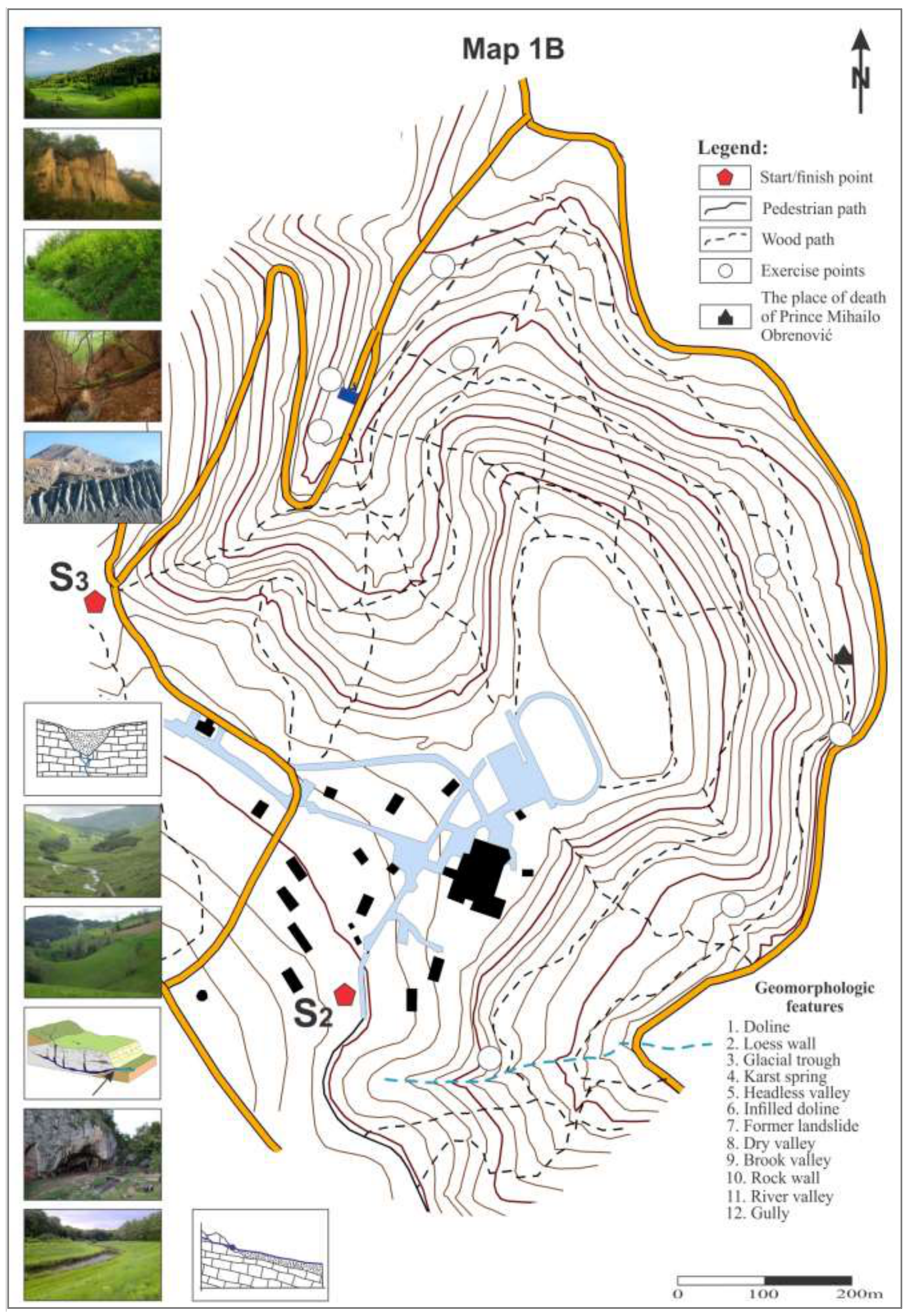
Walk from Stop S2 at the Amphitheater on the eastern part of Pioneer City to Stop S3.
On your way, identify the geomorphologic features, located at the nine places marked by WHITE CIRCLES (Exercise Points) on Map 1B. Label each white circle with a number, corresponding to one of the geomorphologic features from the list, found on the same sheet. Use the small pictures to the left of the map as a reference for feature names. Bear in mind, that the pictures are not in random order.
Some features may be seen on your route twice, and that there are some pictures of features that you will not see in Košutnjak Park.
On the route, you can use pencil to make notes. Use pen to label the white circles with numbers before you hand in the map to the Jury.
At the Stop S3 you will have 10 minutes to answer the questions, written on the Response sheet 1B. Then hand in your Map 1B and Response sheet 1B to the Jury.
Do not forget to write your student number on the cover sheet, map and response sheet.
Task 1B RESPONSE SHEET
1B.1. Analyze the geological profile from Košutnjak hill to Zemun (Figure 1). Identify which rock types from the list below, form layers annotated with capital letters on the profile. Write your answers in the table 1. (1 m)
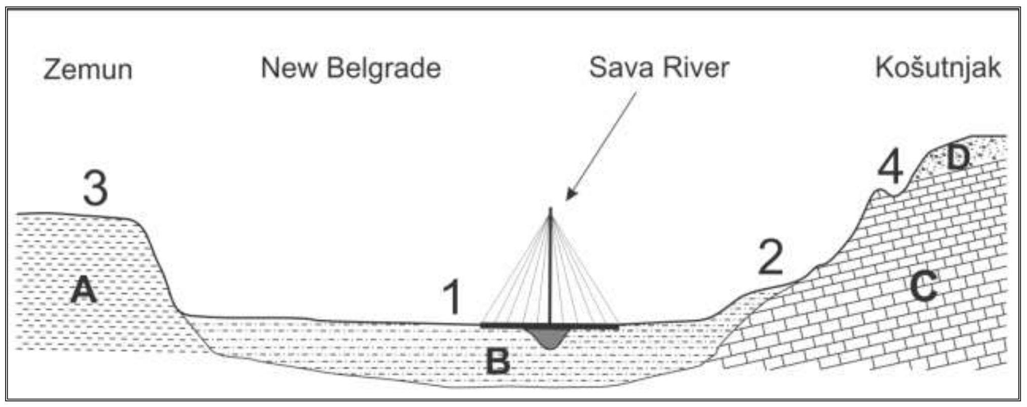
Rock types:
- Andesitic and dacitic tuff
- Loess
- Claystones
- Bedded and thick bedded limestones
- Clays, sands and gravels (Panonian)
- Dacito-andesite and latite
- Sands and clays
- Diabase and spilite
Table 1.
| Letter on Fig. 1 | Rock type |
|---|---|
| A. | __________________________ |
| B. | __________________________ |
| C. | __________________________ |
| D. | __________________________ |
[1 т.]
1B.2. Select from the list (below) the kinds of relief surfaces that correspond to the numbers on the profile, and enter their numbers in Table 2. Arrange them in descending order of age (from oldest to the most recent one). (1 m)
Relief surfaces list: the surface of fluvial denudation, loess plain, river terrace, volcanic plateau, river floodplain, karst surface, plain of marine accumulation, the bottom of the tectonic plate.
Table 2.
| Number (from Fig. 1) | Relief surfaces |
|---|---|
[1 т.]
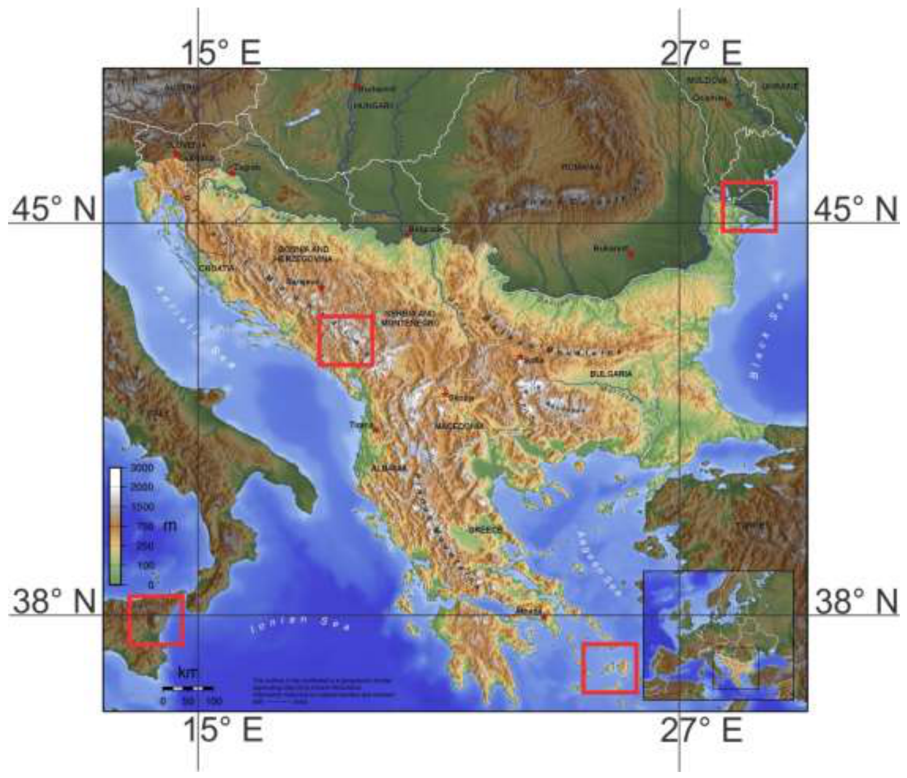
1B.3. In which area marked by a RED SQUARE on the map (figure 2), you can most probably find geomorphologic features, similar to those typical for the Košutnjak park? Provide your answer with the geographic coordinates of the approximate centre of this box, to the closest whole degree (no minutes or seconds). What is the common name of this type of relief (terrain)? (1 m)
Coordinates: _____________________________________________________
Type of relief, or terrain (common name): _____________________________ [1 т.]
Решение
Внимание: Непълно решение
В архива няма официално решение на тази задача.
Оригинал в Архива: FIELDWORK 1 TASK 1B.pdf