iGeo 2018, Теренна работа — Задача 1. Task 1A
15th International Geography Olympiad — Québec City, Canada — 31 July – 6 August, 2018 — FIELDWORK EXERCISE 1 — TASK 1A · 31 юли 2018 г. · 16 т.
Fieldwork Site Context
The area you are in, Charlevoix, is remarkable both geographically and historically. Geographically, you are on the north shore of the St. Lawrence River, a key access point into Canada from the 1600s until today. The region was designated a World Biosphere Reserve by UNESCO in 1989. The area’s elevation ranges from 0-1150m above mean sea level, and is characterized by rolling hills, Canadian Shield (old metamorphic bedrock), river ecosystems, estuarine tidal marshes and mud flats, mixed forest, boreal forest, and alpine tundra.
Key faunal species include beluga whale and blue whale, wolf, caribou, moose, and cougar.
Historically, this was one of the first areas settled in Canada. The economy was originally water-based (coastal navigation, fisheries). Today the economy is based on tourism and agro-forestry.
The diversity of land uses and the varied topography has resulted in an appealing landscape for artists. This area is famous as an arts community and celebrates and supports a unique and rich visual arts heritage. Recently the city of Baie-Saint-Paul adopted a policy aimed at promoting its rich heritage and setting guidelines for its cultural development. It also adopted and put into action a sustainable development policy. This series of initiatives earned it the title of Cultural Capital of Canada.
The City of Baie-Saint-Paul initiated a landscape plan this year. The goal of the plan is to identify local landscapes that are valued by the citizens, understand the landscape qualities that are appealing, and define specific goals and outcomes to ensure sustainable development of their landscapes. The first steps in developing the plan are:
- consultation with citizens through a survey, and
- development of an initial landscape plan.
The City sent out a survey to the citizens asking them to identify:
- their favourite landscapes,
- the landscapes which best represent the area, and
- aspects of the landscape that are disliked.
Today as part of the Fieldwork Test, you will explore two of these landscapes:
- The Boisé du Quai (coastal area), deemed the most favourite area, and the third most representative of the area, and
- Downtown Baie-Saint-Paul, deemed the second favourite area, and was voted the most representative landscape of the area.
These two areas were also identified as important viewpoints in the area, indicating their uniqueness and value to citizens and tourists.
Location: Baie St. Paul City Centre
Time duration: 90 minutes total
Marks: 16
Instructions:
- You will have 15 minutes to read the introduction to this exercise on page 4 and read through the task entirely before starting. You will only have one chance to move through the city, and will need to be aware of the type of data you need to collect.
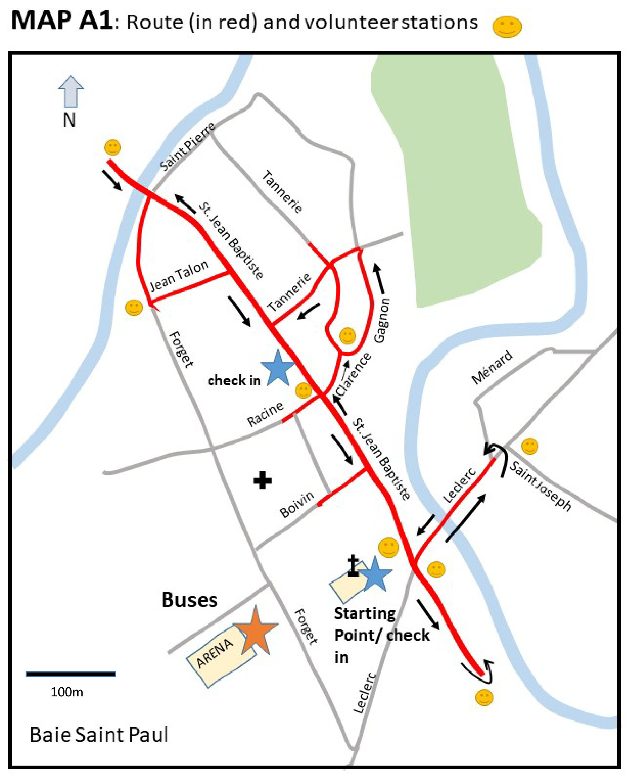
- You will have 75 minutes to explore the streets of the city centre indicated on Map A1 and complete the tasks. You will have to move quickly, but be careful along and when crossing the streets.
- Remember no phones are allowed to be used, and you are not allowed to go into businesses to ask for help with the exercise. This means you must check in with the volunteers on the streets who will let you know the time.
- Before beginning, ensure your student number is written on the top of every page.
- If you need help during the activity, look for one of the volunteers stationed around the fieldwork area. You will be able to see where they are located by looking for a smiley face ☺ on Map A1.
- In an emergency, please go to either of the check-in areas or have someone call Julie at 1(418) 575-9403 or Maxwell at 1 (581) 984-6807.
Условие
Introduction:
In addition to the beautiful physical landscapes, the citizens here also appreciate aspects of human geography, particularly how their unique culture and values create a special type of urban landscape. In a recent survey, Baie-Saint-Paul citizens voted the downtown area as the most representative landscape of their region, and also one of their favourites. The local history of art is a key element of the cultural heritage of the city, and forms the basis of the tourism industry.
Your task is:
- to explore the downtown area by following the route drawn in red on Map A1
- to complete an inventory of cultural heritage that reflects the art and historical culture that is so important to this city. (Map A2 – on a separate sheet)
- to identify the areas that are not attractive and so reduce a tourist’s appreciation of the city’s culture and landscape. (Map A3).
Note – there is a large area to walk around, you must move quickly, but be safe and respectful of the citizens and visitors to Baie-St-Paul. Cross only at crosswalks and watch for cars at all intersections.
- Please move in the direction of the arrows and stay on the red route
- Report to either check-in at the designated time
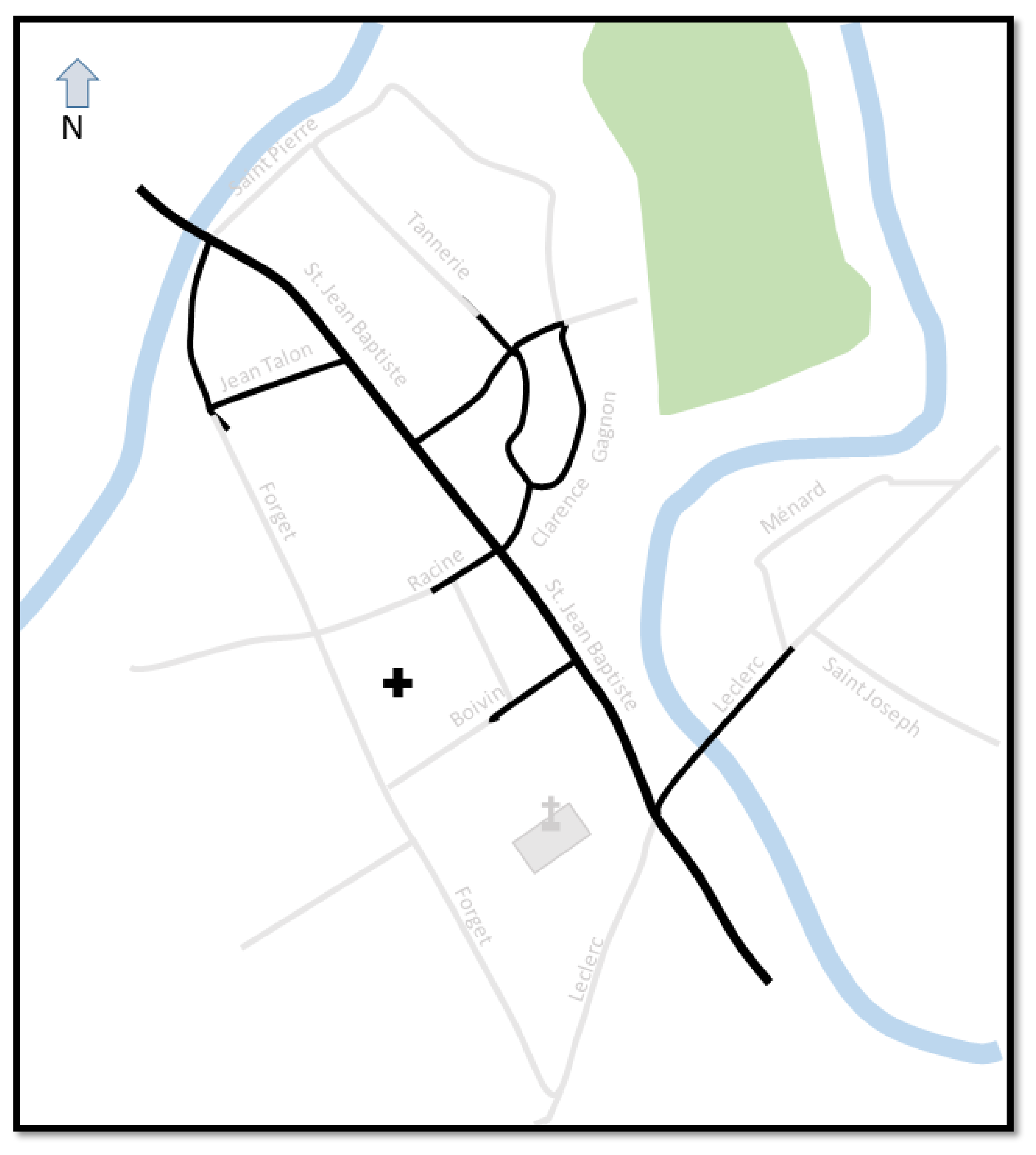
1) On your walk, observe and map your observations on Map A2 (separate sheet).
You will need to decide what symbols you will use. You may label and annotate your map.
Mark the following features on your map:
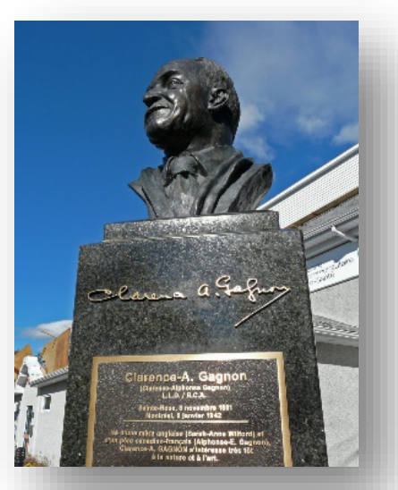
a. Statues (busts) that celebrate a particular landscape artist
i. Indicate the location of the statue only (not the artist’s name)
b. Other features or elements that reflect the art culture of the city
i. Indicate location and type of feature.
ii. List the types of features you observe in Table A1
c. Other features or elements that reflect the history of the city
i. Indicate location and indicate type of feature.
ii. List the types of features you observe in Table A1
d. Businesses that reflect the art culture or heritage of the city
i. Indicate location of business
ii. List the types of features you observe in Table A1
You will be able to use this map in the written part of the fieldwork exercise to help you remember what you are seeing today.
Table A1 Types of features relating to cultural heritage (art and history) observed (5 marks)
| Your map reference (number and/or symbol) | Type of feature (eg statue) |
|---|---|
| statue | |
[5 т.]
2) Identify three spaces or features that are not attractive, and could reduce a tourist’s appreciation of the city’s cultural landscape. Describe these areas in Table A2. Record the location of each of these three areas on Map A3. (6 marks)
Table A2 Three examples of spaces that do not fit Baie-Saint-Paul’s theme of cultural or art heritage.
| Space | What is the current function of this space |
|---|---|
| 1 | |
| 2 | |
| 3 |
[6 т.]
3) 3. On Map A3, draw the boundary between the tourist and residential areas. Use a dashed line to indicate the boundary. (Example - - - - - - - - - - - - - - ) (5 marks)
Hand in this booklet to a check point (MAP 1A) at the designated time
Решение
Внимание: Непълно решение
В архива няма официално решение на тази задача.
Оригинал в Архива: FWE 1A QUESTION_2018iGeo.pdf