iGeo 2021, Теренна работа, част I — Задача 4. SITE 4 – RIVER
17th International Geography Olympiad — Istanbul, Turkey — 10-16 August 2021 — Fieldwork Exercise Part I — Tasks · 10 август 2021 г.
Внимание: Бележка към темата
The archive holds no official solutions or marking scheme for this Fieldwork Exercise; the printed Map of the FWE-I area and the Response Sheet referred to in the tasks are not part of this file.
Dear iGEO participant,
Before starting your virtual trip of the Sariyer district of Istanbul city, please read these guidelines.
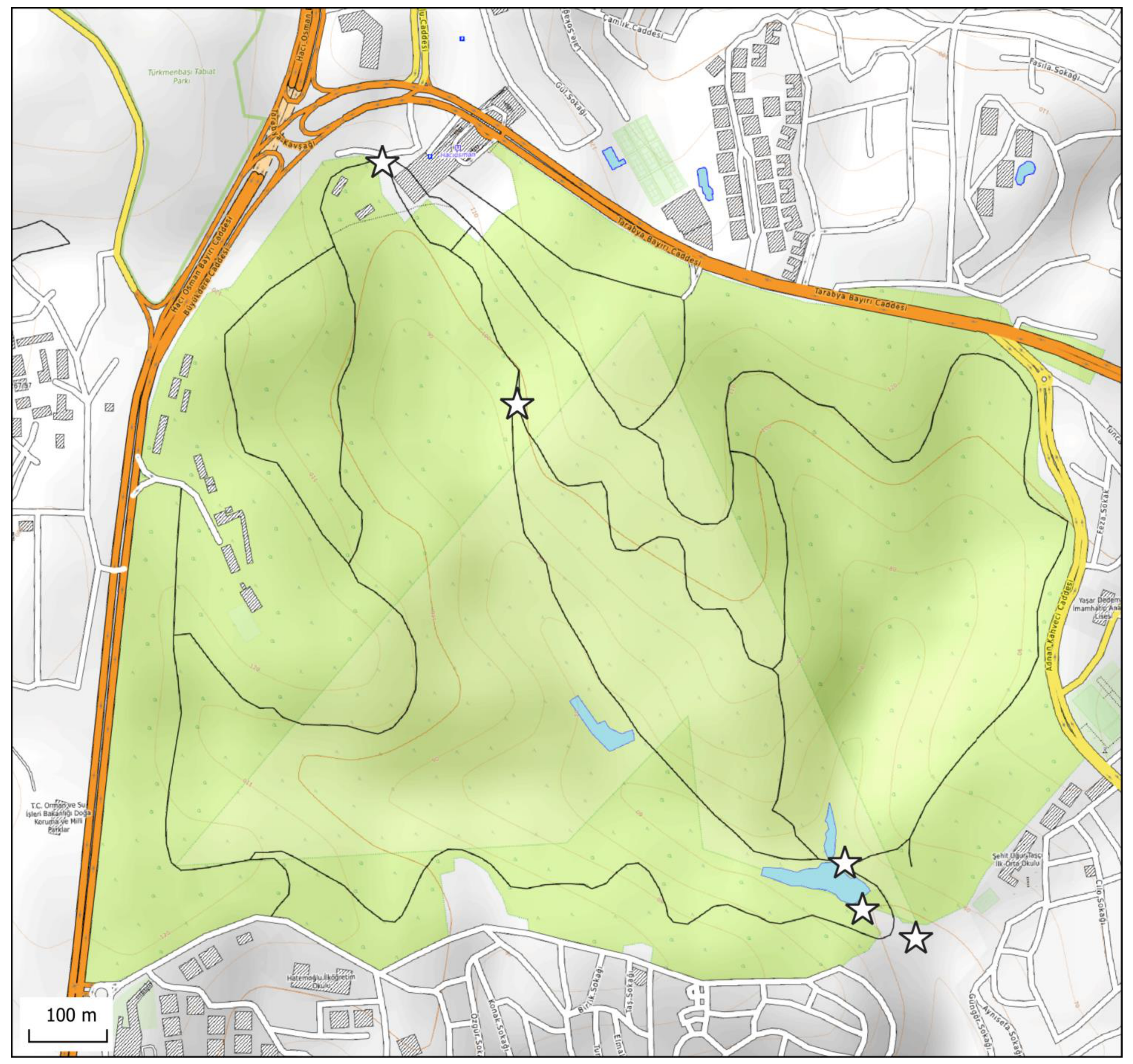
- You have the printed Map of the FWE-I area. Use this map to orient yourself and find the location of five topical sites. The sites are marked on the map, but not labelled.
- The sequence of moving from one site to another is in numeric order: Site 1 (Start) → Site 2 → Site 3 → Site 4 → Site 5 (Finish).
- The absolute height (elevation) at each site is lower than of the previous one on the route. Always go down!
- “Leaving” one site and “arriving” at the next one, do not return. Always move forward!
- At each site you will get tasks you need to complete. For FWE-I you can gain maximum 15 marks.
- You are to decide for how long you will be “staying” at each site.
- Answers should be written in English on the Response Sheet. For answers use a pen with a dark blue tint only. Do not forget to write your participant code in the upper right corner of both pages of the Response Sheet.
- This presentation will be stopped when 60 minutes end, regardless of whether you have visited all five sites, or not. Deliver your Response Sheet to the supervisor of your exam immediately then.
- Keep the Map with you, it can be used as reference for Part II of the Fieldwork exercise (FWE-II).
Good luck!
Условие
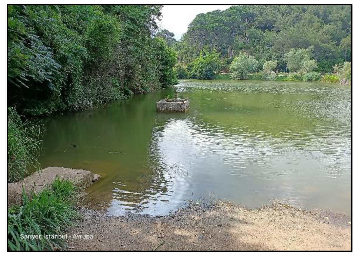
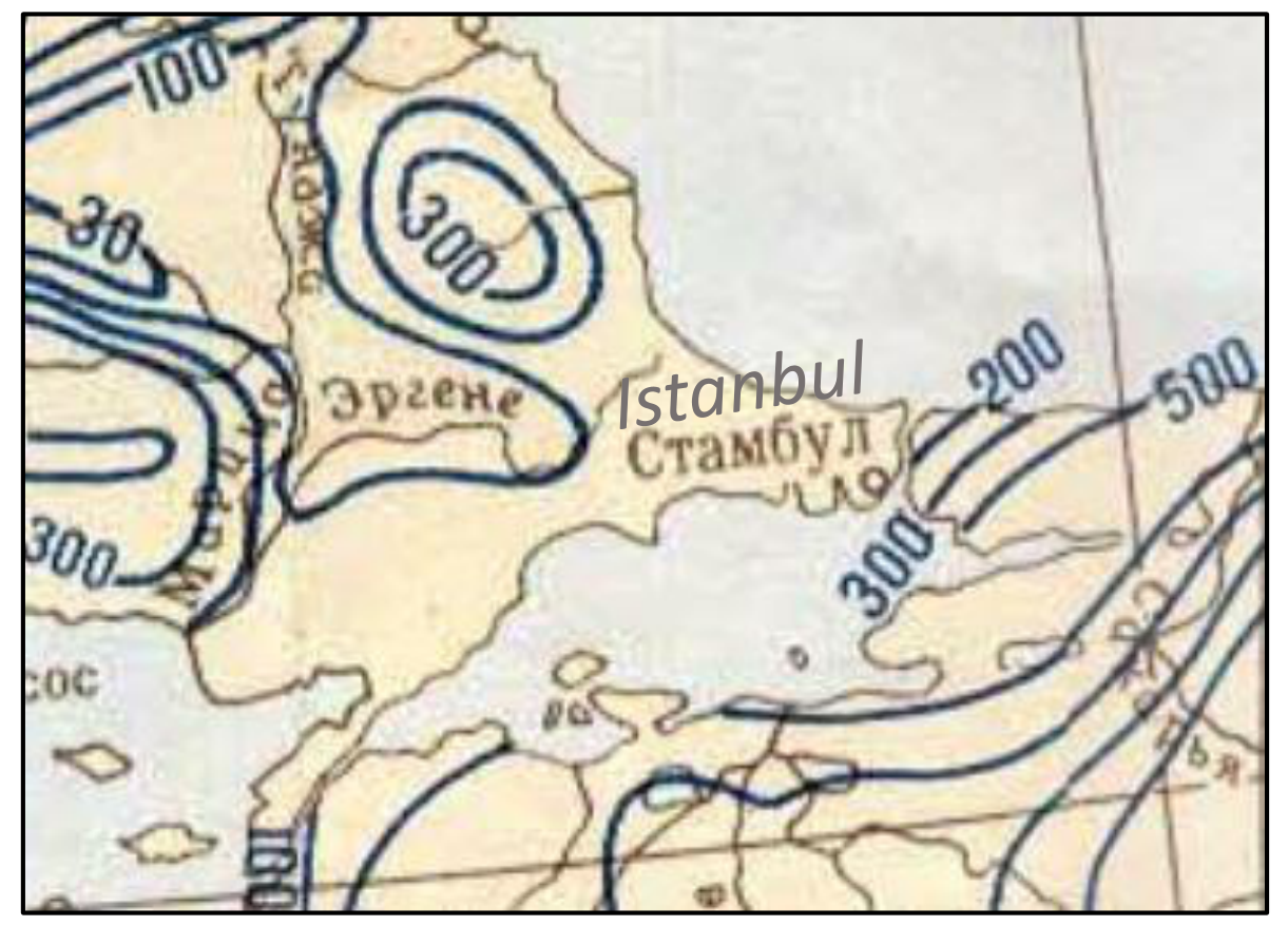
Site 4 is located on the dam over a small river running through the Ataturk urban forest.
Consult the map extract on the next page and circle on the printed map the catchment area of this river.
4.A. Estimate the annual runoff of this river ().
4.B. In urban households equipped with water pipe and sanitation systems, the water consumption norm per capita is 150 liters. How many people could hypothetically get all the water they need from this river? (provide a number)
4.C. Why in real life, is this number much lower, and what are the options for make it closer to the hypothetic number?
Write your answers on the Response Sheet and move to the next site.
Решение
Внимание: Непълно решение
В архива няма официално решение на тази задача.
Authors and sources
Authors of FWE Part I: Alexey Naumov, Eyup Artvinli, contribution: Mikhail Drugov Natalia Frolova, Oxana Klimanova, Alexander Zherenkov
Sources of images and data:
Photos: E. Artvinli, A. Naumov
Site 2. “Quercus frainetto, Botanical Garden in Poznań” by Radomil is licensed under CC BY-SA 3.0. Файл:Quercus frainetto RB2.JPG — Википедия (wikipedia.org) https://ies-ows.jrc.ec.europa.eu/efdac/download/Atlas/pdf/Pinus\_halepensis\_brutia.pdf Ficus carica (plantsam.com); D. Semeikin Yu. 2012. Image of Acer mandshuricum Maxim. // Plantarium. Plants and lichens of Russia and neighboring countries: open online galleries and plant identification guide. 2007—2021. https://www.plantarium.ru/lang/en/page/image/id/135063.html; E. Kishinevsky V. 2020. Image of Juglans regia L. // Plantarium. Plants and lichens of Russia and neighboring countries: open online galleries and plant identification guide. 2007—2021. https://www.plantarium.ru/lang/en/page/image/id/671177.html ;. “Disposición de hojas y ramas de un ejemplar joven de pehuén (Araucaria araucana)” by CARLOS TEIXIDOR CADENAS is licensed under CC BY-SA 3.0. Hojas y ramas de pehuén (Araucaria araucana). Icalma, Región de La Araucanía, Chile.jpg (4896×3672) (wikimedia.org)
Site 3. http://rockref.vsegei.ru/petro/https://openjicareport.jica.go.jp/pdf/11707833\_03.pdf / Chapter 6. Urban Conditions for Earthquake Disaster Management Consideration
Site 4. Mean annual runoff map, 1 : 10 000 000.
Site 5. Автор: Gustavb (обсуждение · вклад) - Собственная работа, используя: Eukleides, Общественное достояние, https://commons.wikimedia.org/w/index.php?curid=584159 Unit circle angles.svg
Оригинал в Архива: iGEO_2021_FWE-I Tasks.pdf