IAO 2012, Практически тур — Задача 7. Болид
XVII Международна астрономическа олимпиада — практически кръг, българско издание · 16 октомври 2012 г. · 10 т.
Забележка (група α, β)
Забележка: Ако откриете някъде в задачите невъзможна ситуация, напишете на английски „impossible situation“.
Забележка (група α)
Забележка: Ако намерите някъде в задачите невъзможна ситуация, напишете на английски „impossible situation“
Забележка (група β)
Забележка. Ако откриете някъде в задачите невъзможна ситуация, напишете на английски „impossible situation“
Fireball: printed solution values
The official key acknowledges that point II is plotted incorrectly. Section 7.2 gives A/B latitudes 36.47°/36.10°, while section 7.4 and the final table give 36.49°/36.11°. Both are retained.
Moon: missing plotting sheet and printed discrepancies
The blank eccentric-orbit plotting sheet (a) is absent from the full year inventory. The supplied geographic grid belongs to Fireball. The official completed orbit diagram is retained in the solution. The key prints an arcsecond mark after the distance 384400, uses Moon diameter 3476.4 km (3476 in its calculation), while the reference sheet lists 3475 km; values are retained. Its culmination difference table is reproduced as printed, including entries that do not equal the adjacent clock-time difference.
Clusters: missing plotting sheets and printed discrepancies
Blank graph papers (A) and (B) are absent from the full year inventory. Complete data and completed official plots are retained. The colour-colour heading prints NGC6282; the 8.4 explanation prints NGC2686; the actual problem is NGC2682. The Hyades absolute-magnitude equation and 0.75 answer are retained without recalculation.
Source ownership
Bulgarian questions and all three original IDs are retained. English source PDFs confirm shared αβ-7, α-8 Moon and β-8 Clusters. All six key images and full practical rubric apply to this combined Bulgarian edition. Four theory-labelled reference sheets were inspected: orbital data support Moon and the H-R diagram is explicitly cited by Clusters; constants and individual-star data remain separately attributed reference context, not additional practical tasks. No Bulgarian key was found.
Условие
В три различни наблюдателни пункта (I, II, III) се е наблюдавал болид. Координатите на наблюдателните пунктове, височината и азимутът на началната и крайната точка на пътя на болида са представени в Таблица 1. Азимутите са измерени по часовниковата стрелка от посоката север, височината се измерва в градуси над хоризонта. Следвайки посочените по-долу указания, определете реалната траектория и местонахождението в местността, където е паднало метеоритното тяло.
Таблица 1. Данни от наблюдението на болида
| наблюдателен пункт | дължина | ширина | начална точка (A): азимут | начална точка (A): височина | крайна точка (B): азимут | крайна точка (B): височина |
|---|---|---|---|---|---|---|
| I | 127,3° и.д. | 35,7° с.ш. | 17° | 35° | 77° | 10° |
| II | 128,5° и.д. | 37,0° с.ш. | 235° | – | 139° | – |
| III | 128,5 и.д. | 35,4° с.ш. | 325° | – | 48° | – |
7.1. Разполагате с милиметрова хартия. Отбележете трите пункта на наблюдението на болида (I, II и III) и нарисувайте проекция на неговата траектория. [3 т.]
7.2. Пресметнете дължината и ширината на началната точка (, ) и крайната точка (, ) на пътя на болида, а също дължината L на проекцията на неговата траектория върху земната повърхност. [2 т.]
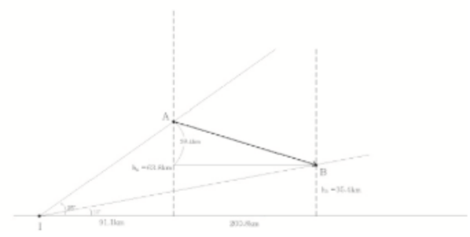
7.3. Намерете височините над земната повърхност на началната точка и крайната точка от движението на болида. [3 т.]
7.4. Къде ще може да се намери метеоритът, ако той не изгори в атмосферата и достигне до земната повърхност? Определете дължината и ширината (, ) на мястото на падането на метеорита. [2 т.]
Координатна мрежа
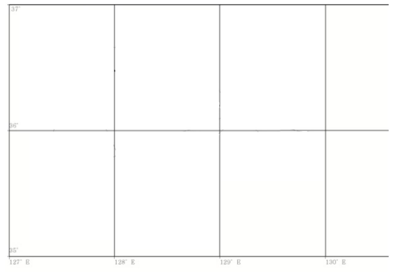
Накрая пречертайте дадената по-долу таблица в тетрадката и попълнете в празните клетки получените резултати.
| Точка | дължина | ширина | L (km) | (km) | (km) | Метеоритът трябва да се търси в точка: дължина | Метеоритът трябва да се търси в точка: ширина |
|---|---|---|---|---|---|---|---|
| A | |||||||
| B |
Отговори
- Official final table: A (127.60°E, 36.49°N), B (129.45°E, 36.11°N); L = 173.5 km; hA = 63.8 km; hB = 35.4 km; impact (131.76°E, 35.64°N). The key earlier gives slightly different latitudes.
Решение
Официални скици на решенията и основни критерии за оценяване, на оригиналния английски език.
7.1
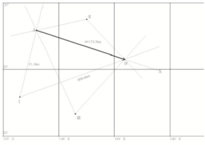
Observing points I, II and III are plotted as in the figure (point II is not correctly plotted below, but when plotted correctly on the gridded paper, the answer becomes clear). Then by drawing only using azimuthal angles, projected points A and B can be obtained, as intersecting points.
7.2
Read off from the grid, and coordinates can be easily obtained as (127.60°E, 36.47°N) for point A, and (129.45°E, 36.10°N) for point B.
Then one should first convert the differences in angle into distance, and then use Pythagorean principle, such that
where the conversion factor 4.8/5.8 for longitudinal distance per one degree longitude can be read off from the correctly scaled gridded paper or using , and one can use 110 km / (latitude degree). Then km.
7.3
Once points I, A & B are correctly marked, the distance and can be calculated using Pythagorean principle just as in problem 2, which are 91.1 km and 200.8 km. And using altitudes observed from point I, one can get
7.4
If the fireball hits the surface, the full projected trajectory from point A to the hitting point (let’s call it C), AC, is the multiple of the projected distance AB by a factor of . The same multiplication factor can be used to get the trajectory on the longitude and latitude separately, such that
| Point | Longitude | Latitude | (km) | (km) | (km) | Meteorite longitude | Meteorite latitude |
|---|---|---|---|---|---|---|---|
| A | 127.60°E | +36.49°N | 173.5 | 63.8 km | 35.4 km | 131.76°E | 35.64°N |
| B | 129.45°E | +36.11°N |
Practical round. Basic grading criteria
| Part | Criteria | Points |
|---|---|---|
| 7.1 | Marking points I, II, III correctly. Marking and drawing the fireball trajectory correctly | 3 |
| 7.2 | Getting longitude and latitude of Points A, B correctly. Getting distance with correct scaling over longitude and latitude | 2 |
| 7.3 | Getting the right geometry. Final values of heights within 10 percent of error | 3 |
| 7.4 | Getting the right geometry. Final values of the correct position within 10 percent of error | 2 |
Оригинал в Архива: bgpract.pdf · официални решения: practsol1.png · допълнителни данни: practsol2.png · допълнителни данни: practsol3.png · допълнителни данни: practsol4.png · допълнителни данни: practsol5.png · допълнителни данни: practsol6.png · допълнителни данни: pract_cr.png · допълнителни данни: paper.png · допълнителни данни: alphapract.pdf · допълнителни данни: betapract.pdf · допълнителни данни: data_1.png · допълнителни данни: data_2.png · допълнителни данни: data_3.png · допълнителни данни: data_4.png