iGeo 2014, Писмен тест — A. Section A · Geology and Coastal Landforms
11th International Geography Olympiad · Written Response Test · 12 август 2014 г. · 15 т.
Внимание: Бележка към темата
The original resource PDF omits the D2 boat-school photograph and explicitly withholds the E3 malaria map from public display; the official key supplies no E3 answer. Literal native table, wording, examiner/report label and exemplar/key disagreements are retained in their attributed source scopes.
Instructions for the Students
Instructions for the Students
Fill in your name, team and iGeo student number on the front page of this Question and Answer Booklet.
Fill in your iGeo student number in the boxes on top of the pages in this Booklet.
This test consists of 6 Sections.
The maximum total mark is 90. The mark for each question is given in the margin at the beginning of the question. There are a maximum of 15 marks for each Section.
Answer all questions in the spaces provided in this Booklet.
Check the backs of pages as questions are printed on both sides of a page.
Give only the required number of answers (reasons, examples, etc.). For instance, if the question asks for 2 reasons and you give more than 2, only the first 2 reasons will be marked.
The Resource Booklet contains Sources referred to in this Booklet.
You may use a calculator during the test.
Time: 180 minutes for students not educated in English,
150 minutes for students educated in English.
- Students not educated in English are allowed to use bilingual dictionaries during the test.
Good luck!
Instructions for the Markers
Instructions for the Markers
Check if the iGeo Student Numbers are on each sheet before dividing up the paper.
This test consists of 6 Sections.
One whole Section per marker and double-checker.
Check whether the answer continues outside the designated area. No credits will be given to answers in the Resource Booklet.
The maximum total mark is 90. The mark for each question is given at the beginning of the question. There are a maximum of 15 marks for each Section.
Get the hang of the full range of answers by reading through a few papers with your co-marker before you start your marking.
These answers are not exhaustive. Credit any relevant answer.
Mark only the required number of answers (reasons, examples, etc.). For instance, if the question asks for 2 reasons and there is more than 2, only the first 2 reasons should be marked.
Put your mark next to the question number in the column on the left – it eases the work of the person who has to put the numbers into MS Excel. Total the marks by the title of the Section.
The Moderators (Sue and Anu) will sample the marking of all teams.
Условие
Section A: Geology and Coastal Landforms. Maximum 15 marks.
Question 1 (6 т.)
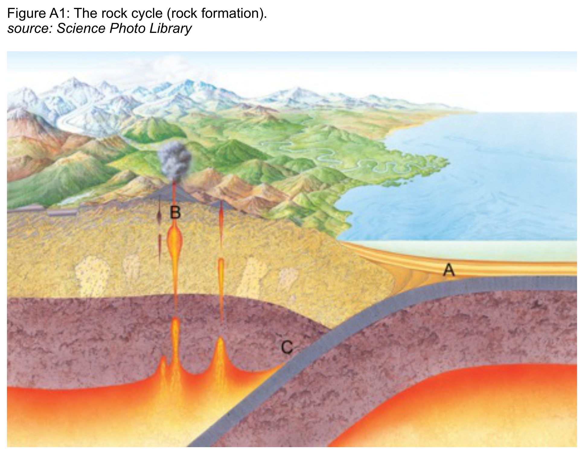
Study Resource Booklet Figure A1: The rock cycle (rock formation). Fill in the table:
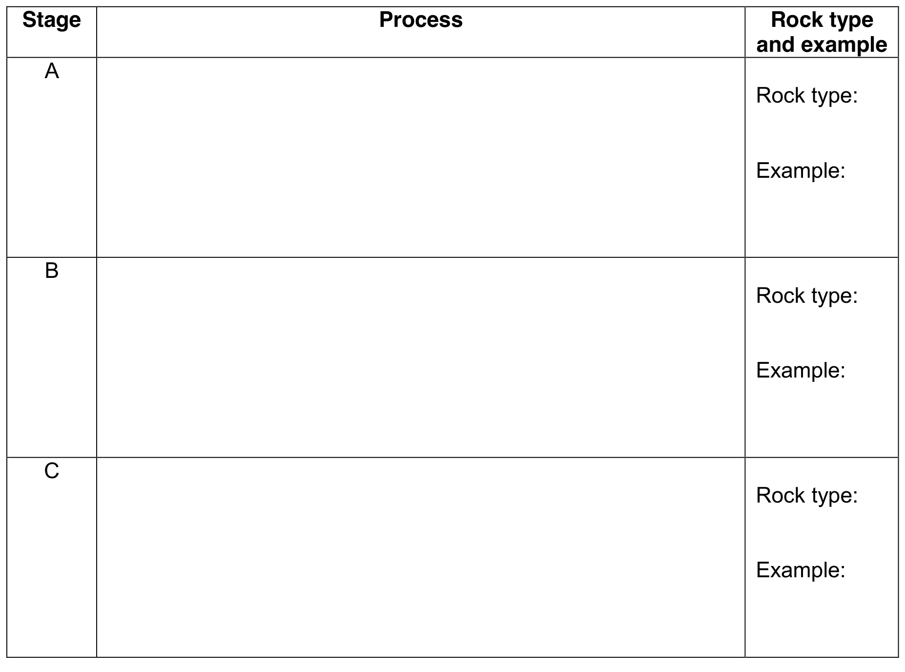
| Stage | Process | Rock type and example |
|---|---|---|
| A | ______ | Rock type: ______; Example: ______ |
| B | ______ | Rock type: ______; Example: ______ |
| C | ______ | Rock type: ______; Example: ______ |
a Describe the processes occurring at stages A, B and C of the rock cycle;
b Name the rock type formed at each stage and give an example.
Question 2 (5 т.)
2 Study Resource Booklet Figure A2: A rocky coast. Choose 2 features of the coastline and explain in detail how natural processes are shaping them.
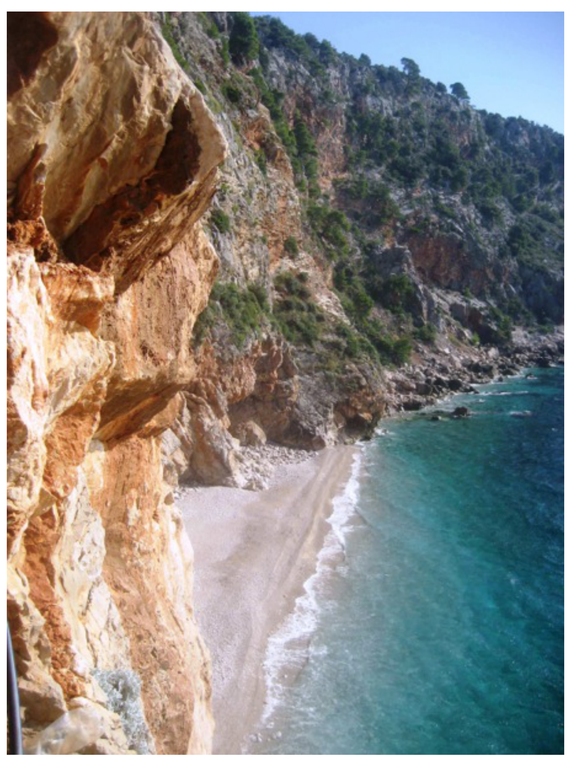
Feature 1: ______
Natural processes: ______
Feature 2: ______
Natural processes: ______ [5 т.]
Question 3 (4 т.)
3 Draw an annotated diagram or set of diagrams to show how a delta is formed.
[The native booklet provides a blank diagram space.] [4 т.]
Решение
Official Marking Scheme · Section A.
Question 1 (6 т.)
The answers are linked. The students must get the right rock type and example with the right process to get the full 2 marks for the stage.
A. Deposition occurs from rivers entering the sea and from sediment suspended in the sea. Layers of sediment are built up on the sea floor and compaction and sedimentation lead to these sediments forming rocks called sedimentary rocks e.g. sandstone, shale, limestone, gritstone. B .Rocks come under intense pressure and heat and this leads to melting of the rocks. The less dense material forms magma chambers or rises to the surface in the form of volcanoes or igneous intrusions – igneous rock, e.g. basalt, granite, rhyolite.
C. At destructive plate boundaries one plate is subducted beneath another. At depth the plate is put under great pressure and subject to great heat and metamorphic rocks are formed e.g. gneiss, marble, schist.
Question 2 (5 т.)
Answer: 5m – 0.5 marks for feature and 2 marks for explanation.
Features such as: (vertical) cliffs, vegetation on cliffs, beach, wave cut platform or boulders on the beach. Processes have to be connected to the named feature. Maximum 2 marks for a list. Hydraulic action. Air may become trapped in joints and cracks on a cliff face. When a wave breaks, the trapped air is compressed which weakens the cliff and causes erosion. Abrasion. Bits of rock and sand in waves grind down cliff surfaces like sandpaper. Attrition. Waves smash rocks and pebbles on the shore into each other, and they break and become smoother. Solution. Acids contained in sea water will dissolve some types of rock such as chalk or limestone. Mass movement. The base of the cliff is undermined by the waves and material slumps or falls down. Deposition forming the beach. Waves transport and deposit sediment from further along the coast or out to sea.
Question 3 (4 т.)
Should include some of the following:
features: meander, distributaries, bars; processes: velocity slows and deposition occurs, largest particles first then finest further down the delta, layers of sediment build the delta out into the sea.
Not labels but annotations – short comments to a diagram in order to describe or explain. 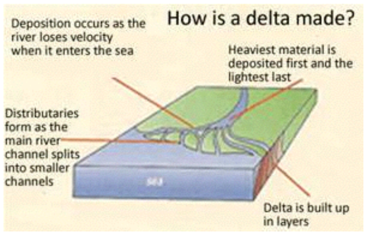
Example Diagram only
- As rivers near the sea they contain high sediment loads and the rivers start to spread out laterallly.
- This lateral movement of water reduces hydraulic radius and increases wetted perimeter.
- This causes sediment to be deposited.
- This sedimentation builds up over time and can create small islands which split the channel, similar to braided streams.
- This can happen again and again until the river consists of a number of smaller streams separated by islands.
- If sediment is coarse grained arcuate deltas form. If it is fine grained then birds foot deltas can be created (e.g. Mississippi).
- Sediment is often deposited on the sea ward side, which builds the delta outwards into the sea. These areas are called fore beds, and are highly unstable. They often collapse and cause mass movements within the sea and clouds of sediment known as turbidity currents.
Committee Report · Appendix 1
Committee Report, October 2014 — Appendix 1. This section contains some examples of good answers with comments from the marking teams in speech bubbles. All the exemplar answers are taken from scripts of students who are not educated in English. These source-attributed exemplars retain their native wording, numbering, marks and disagreements with the Marking Scheme.
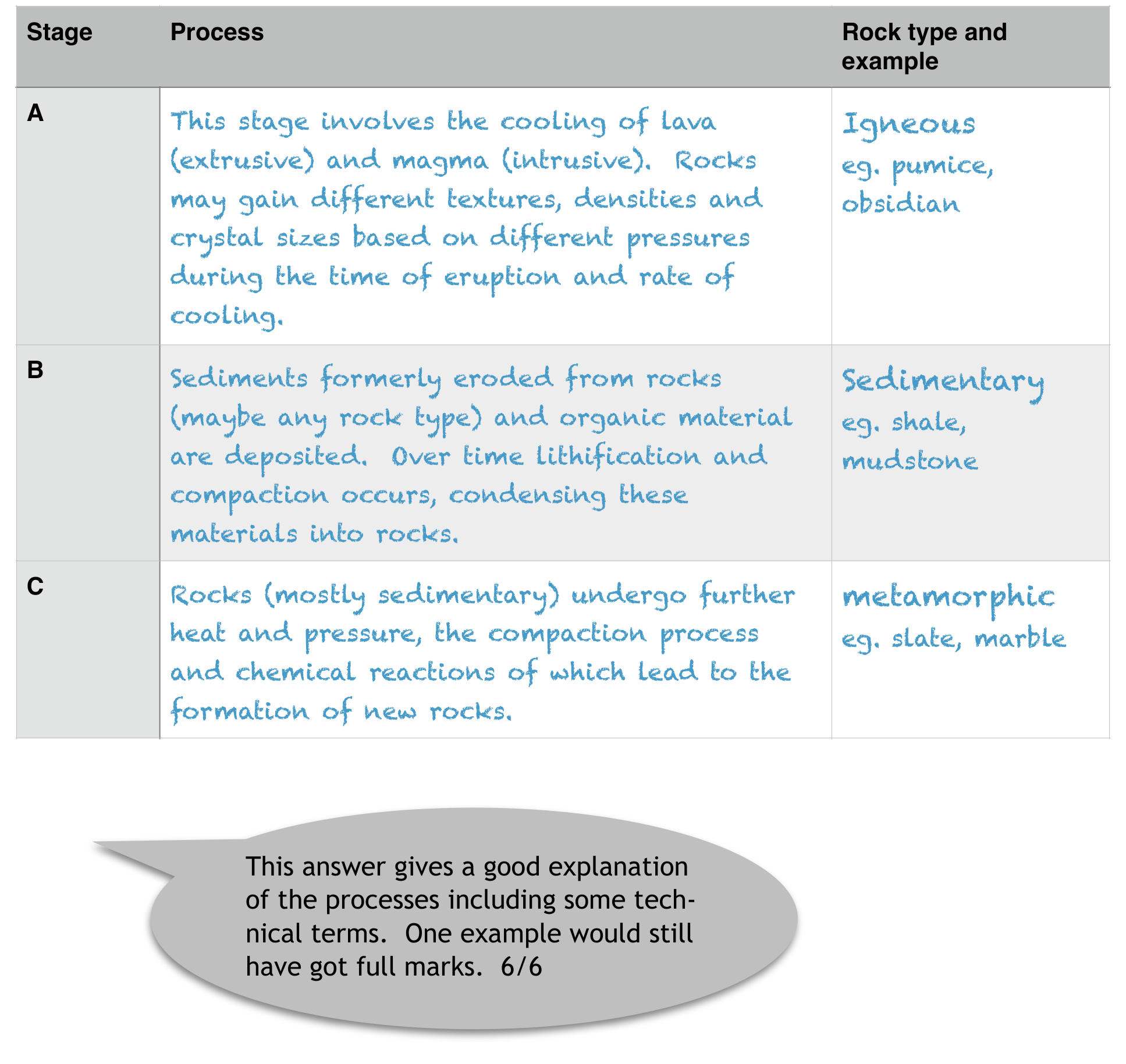
Committee Report exemplar · A1, scored6/6; report A/B rocks disagree with official marking key and remain literal.
Source-attributed student answer and marking-team comment:
Stage Process Rock type and example A This stage involves the cooling of lava (extrusive) and magma (intrusive). Rocks may gain different textures, densities and crystal sizes based on different pressures during the time of eruption and rate of cooling. Igneous eg. pumice, obsidian B Sediments formerly eroded from rocks (maybe any rock type) and organic material are deposited. Over time lithification and compaction occurs, condensing these materials into rocks. Sedimentary eg. shale, mudstone C Rocks (mostly sedimentary) undergo further heat and pressure, the compaction process and chemical reactions of which lead to the formation of new rocks. metamorphic eg. slate, marble This answer gives a good explanation of the processes including some technical terms. One example would still have got full marks. 6/6
Committee Report exemplar · A2, scored5/5; complete two student explanations and examiner bubble.
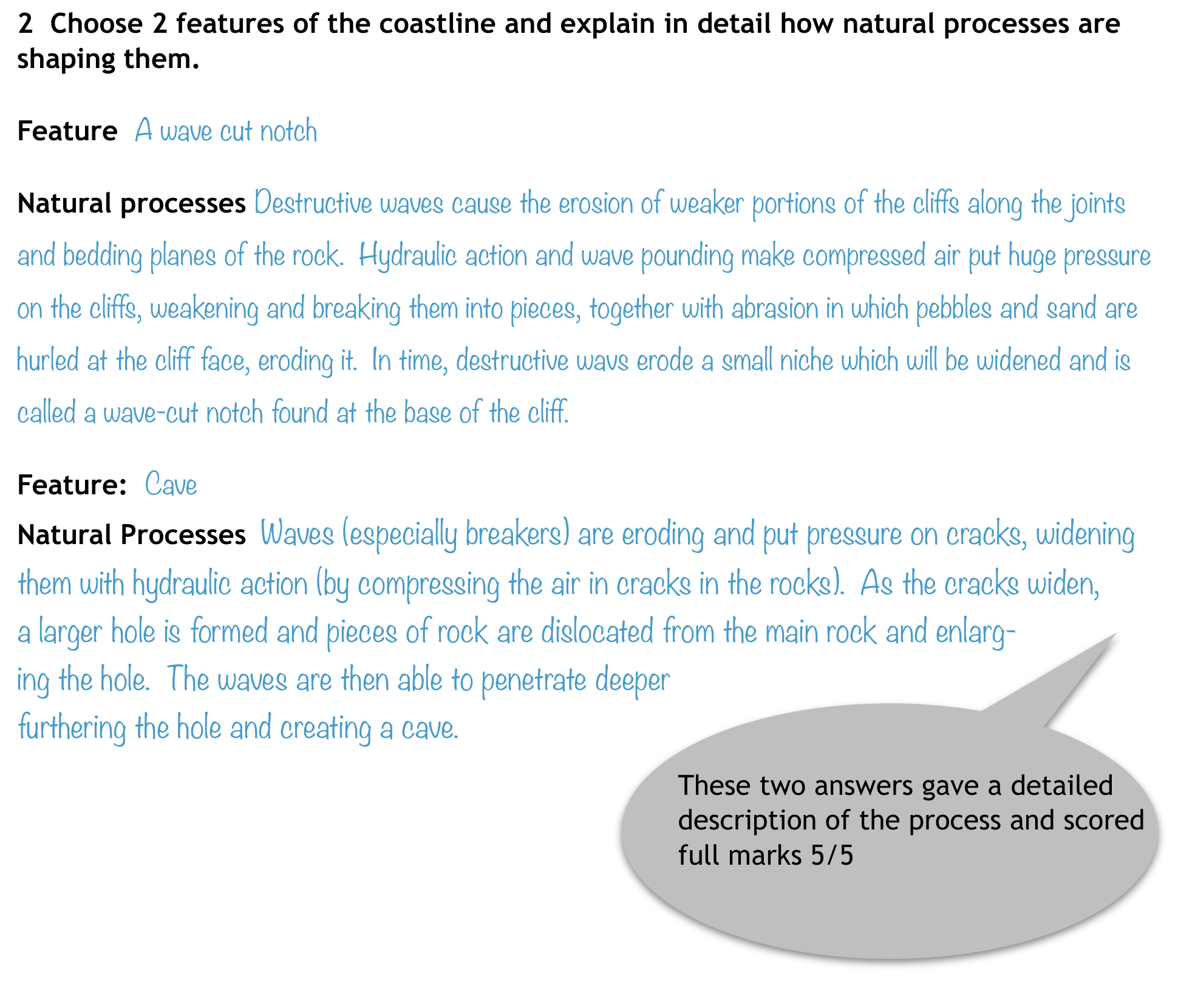
Source-attributed student answer and marking-team comment:
2 Choose 2 features of the coastline and explain in detail how natural processes are shaping them. Feature A wave cut notch Natural processes Destructive waves cause the erosion of weaker portions of the cliffs along the joints and bedding planes of the rock. Hydraulic action and wave pounding make compressed air put huge pressure on the cliffs, weakening and breaking them into pieces, together with abrasion in which pebbles and sand are hurled at the cliff face, eroding it. In time, destructive wavs erode a small niche which will be widened and is called a wave-cut notch found at the base of the cliff. Feature: Cave Natural Processes Waves (especially breakers) are eroding and put pressure on cracks, widening them with hydraulic action (by compressing the air in cracks in the rocks). As the cracks widen, a larger hole is formed and pieces of rock are dislocated from the main rock and enlarging the hole. The waves are then able to penetrate deeper furthering the hole and creating a cave.
These two answers gave a detailed description of the process and scored full marks 5/5
Committee Report · October 2014 · General report
Geography Olympiad 2014 - Krakow
Written Response Test Report
Student Performance
•
Overall the paper was accessible by all students. The total marks were out of 90
with the lowest score being 14 marks (compared to 9 marks in 2013) and the highest score reaching 70 marks (75.5 marks in 2013). The median mark was 47 out of
90 (43 in 2013). Overall this was a higher scoring paper than last year’s WRT.
•
The highest scoring section overall was Section F (Globalisation and Transnational
Corporations) where the median mark was 11 out of 15.
•
Section A (Geology and Coastal Landforms) was the only section where a student
achieved full marks (15)
•
The lowest scoring section was Section C ( Global Ecological Footprint) where the
median mark was 8 out of 15.
•
Section A had several students who did not score at all and Section C and E each
had 2 students who didn’t score at all. However, Section A was also where the
highest mark was achieved.
General Comments
•
The writing committee has continued to make a conscious effort to ask more
‘open’ questions which we hoped would encourage students to write in more extended prose.
•
Questions were structured so that generally, the easier more closed questions came
at the beginning of each section using command words such as identify, outline,
describe, name, and what?
•
The more open, challenging questions came towards the end using command words
such as explain, suggest, comment on and justify.
•
As in previous years, the team also tried to produce sections that integrated physical and human geography topics.
•
We always try to provide a variety of data representation/visualisation (eg. maps,
graphs, tables, etc.) to reflect the range of sources that geographers work with.
•
We also tried to introduce some more modern topics e.g. geography of health; the
solar powered boat schools and the recent expansion of globalisation.
•
Some questions were very poorly answered by students:
o
In question C7 students were asked to comment on the differences between
the data shown in the table for Africa and Oceania. 87 students did not
score on this part.
o
QuestionA4 asked students to draw a series of diagrams to show the formation of a delta. 58 students did not score on this part.62 students were unable to give a reasonable definition of globalisation in question F1.
• However, other questions were more competently answered:
o
Question B2 asked about afforestation and only 8 students were unable to
gain a mark here.
o
Section F2 asked students to give factors influencing the process of globalisation and only 21 students did not score on this section.
o
It was pleasing to see that more than half the students could explain the
impacts of El Nino in Section D2.
Command words
•
There seemed to be fewer instances where students misinterpreted the command
words. This may have been because again time was given for students who are not
educated in English to read and digest the command words before the test starts.
•
The writing committee does not see this should be a particular problem for non-
English speakers.
Marking
Again, I am grateful to everyone who marked the WRT this year and especially to Anu
Printsmann and Dubravka Spevec whose academic backgrounds and meticulous approach contributed to a robust marking process.
Consistency and quality assurance is achieved by teams of two markers marking all the
scripts of the students for one section. The provisional mark scheme was prepared by
the writing team before the test took place. This was adjusted if necessary, by the
paid of geography specialist markers and the moderators (Anu and Sue) after a sample
of 30 papers had been marked. Each pair double marked papers where there was an
issue or marked together and then the moderators sample marked papers from every
team and marked each moderated question with a coloured dot. We moderated approximately 10% of all scripts and at least one question was moderated from a student
from each participating country.
I am confident that this system is effective and robust.
Again, the writing team were pleased with the way in which students attempted all questions in the test. No topic seemed to be inaccessible to students, although certain parts
appeared to pose a problem. This is still a small issue about command words we think for
some countries where students are not educated in English. The writing team recognise
that there is always room for improvement and will always strive to construct a fair and
equitable test.
Additional points:
• We try hard to ensure that there is no cascading disadvantage, ie that students who get
one question wrong are not penalised in subsequent questions.
• Correct exemplification is always considered for extra marks if the mark scheme allows.
• We want to credit what the students know, understand and can do in geography and so
we use positive marking, unless the question requires a specific answer which can be
right or wrong.
• For some of the more ‘open’ questions you will see from the mark scheme that we have
used level marking rather than point marking. This arises from the increased opportunity for students to write extended answers. All the marking team were happy with this
approach.
I would like to express my thanks to all the writing team:
Josef Tan, Anu Printsmann and Dubravka Spevec and to Kath Berg for the hours of work
that went into producing the Written Response Test for the 2014 Geography Olympiad.
In order to support participating countries further, a selection of high scoring answers is
appended below (Appendix 1). This is intended to be accessible from the iGeo website.
Sue Lomas
Chair, Written Response Test Committee
Assessment Coordinator
sue-lomas@talktalk.net
October 2014
Оригинал в Архива: 2014WRT-KrakowQuestionBooklet.pdf · официални решения: 2014WRT-MarkingScheme.pdf · допълнителни данни: 2014WRT-KrakowFinalReport.pdf · допълнителни данни: 2014WRT-Resources.pdf