iGeo 2016, Писмен тест — Задача 1. Section A: Landslides
13th International Geography Olympiad — Beijing, China — 16–22 August 2016 — Written Response Test — Question and Answer Booklet · 16 август 2016 г. · 15 т.
Cover of the Question and Answer Booklet
13th International Geography Olympiad
Beijing, China
16–22 August 2016
Written Response Test
Question and Answer Booklet
Do NOT open the Booklet before instructed to do so by a supervisor.
Name: ........ Team: ........
iGeo student number: ........
Instructions for Students
Fill in your name, team and iGeo student number on the front page of this Question and Answer Booklet.
Fill in your iGeo student number in the boxes on top of the pages in this Booklet.
This test consists of 6 Sections.
The maximum total mark is 90.
The mark for each question is given in the margin at the beginning of the question.
There is a maximum of 15 marks for each Section.
- Answer all questions in the spaces provided in this Booklet in English.
Keep the left margin free for markers.
Please write clearly.
Please use blue (or black) pen, not pencil.
Check the backs of pages as questions are printed on both sides of a page.
There are blank pages which you can use as additional space for your notes.
Please cross through any notes so that we know they are not part of your answers.
If you use these pages for answers, please label them clearly with the Section and question number (e.g. A1).
Where appropriate, please write sentences or phrases not single words.
Give only the required number of answers (reasons, examples, etc.).
For instance, if the question asks for 2 reasons and you give more than 2, only the first 2 reasons will be marked.
The Resource Booklet contains Figures referred to in this Booklet.
You may use a calculator during the test.
Time: 180 minutes for students not educated in English (+10 minutes reading time),
150 minutes for students educated in English (+10 minutes reading time).
- Students not educated in English are allowed to use bilingual dictionaries during the test.
Good luck!
Written Response Test
Contributions from: Belgium, China–Hong Kong, Czech Republic, Indonesia, Poland, Singapore
Committee Convenor: Anu Printsmann (Estonia)
Deputy: Dubravka Spevec (Croatia)
Editors: Jason Flowers (USA), Celestine Hang (Singapore), Alexey Naumov (Russia)
Director of Tests: Susan Lomas (UK)
Booklet layout
Every answer page carries a box „Student number:“ at the top. Pages 5, 6, 9, 16 and 20 end with „This Section continues on the next page.“ Pages 14 and 18 print only:
This page is intentionally blank (you can use it for your notes (please cross them through afterwards) or for answers, which are clearly labelled with the Section and question number).
The booklet ends with „end ■“ on page 21.
Cover of the Marking Scheme
13th International Geography Olympiad
Beijing, China
16–22 August 2016
Written Response Test
Marking Scheme
Instructions for Markers
Check if the iGeo student numbers are on each sheet (on odd pages) before dividing up the Test.
This test consists of 6 Sections.
The maximum total mark is 90.
The mark for each question is given in the margin at the beginning of the question.
There is a maximum of 15 marks for each Section.
- One whole Section per marker and double-checker.
Some lengthy (more than 2 pages) Sections may be divided for two marker-pairs.
- Get the hang of the full range of answers by reading through a few papers with your co-marker before you start your marking.
You can mark together, or after establishing a consensus on how to mark for thoroughness and consistency, act as each other’s double-checkers by marking half of the test and then swapping the pile.
We strongly recommend whenever in doubt, consult your marking partner and, if appropriate, one of the designated Moderators – Anu or Dubravka.
Please develop your own marking/correcting notation system (using +/-, x/0, √ marks), underlining, comments etc. to ease double-checking and sample marking.
These answers are not exhaustive. Credit any relevant answer.
Check whether the answer continues outside the designated area, in the margins or as clearly marked on blank pages.
No credits will be given to answers in the Resource Booklet.
The Test uses two marking systems: point and level marking.
Half marks can only be given where indicated as the total of 90 marks will yield only 40% of the total olympiad result.
Mark only the required number of answers (reasons, examples etc.).
For instance, if the question asks for 2 reasons and there is more than 2, only the first 2 reasons should be marked.
- Put your final mark next to the question number in the column on the left – it eases the work of the person who has to put the numbers into MS Excel.
Please write your numbers clearly.
Please write down any inconsistencies of the Marking Scheme and additional answers or answers not accepted and hand them in after marking to improve the final Marking Scheme.
The Moderators (Anu and Dubravka) will sample the marking of all teams.
Written Response Test
Contributions from: Belgium, China–Hong Kong, Czech Republic, Indonesia, Poland, Singapore
Committee Convenor: Anu Printsmann (Estonia)
Deputy: Dubravka Spevec (Croatia)
Editors: Jason Flowers (USA), Celestine Hang (Singapore), Alexey Naumov (Russia)
Director of Tests: Susan Lomas (UK)
Условие
1. Study Resource Booklet Figure A1: A photograph taken on the island of Viti Levu, Fiji.
Which of the locations A–F was most recently affected by a landslide? [1 т.]
2. Study the figure below: The climatic data of Pacific Harbour, a city on the island of Viti Levu, Fiji.
Which 4 months have the highest risk of landslides?
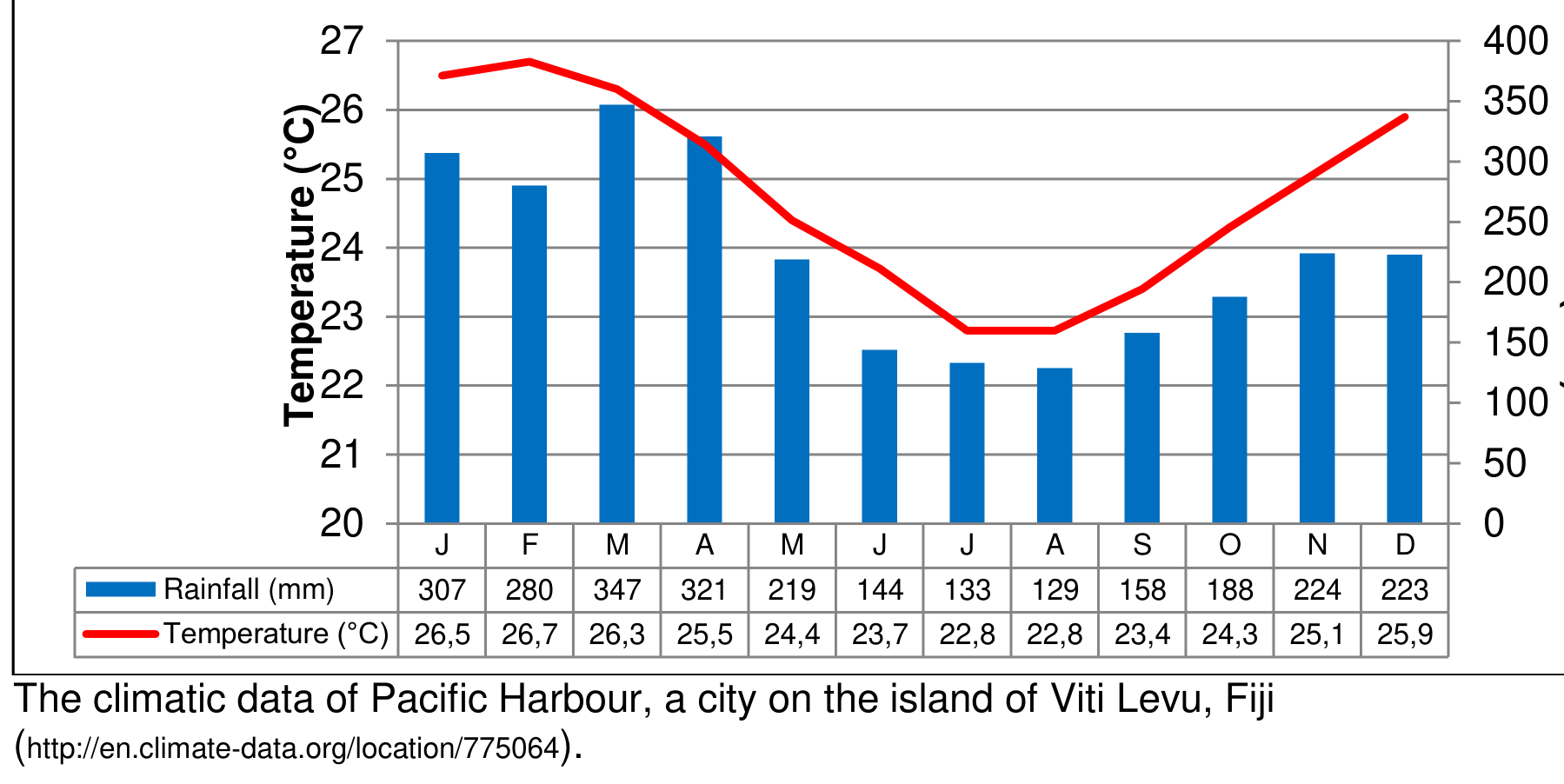
| J | F | M | A | M | J | J | A | S | O | N | D | |
|---|---|---|---|---|---|---|---|---|---|---|---|---|
| Rainfall (mm) | 307 | 280 | 347 | 321 | 219 | 144 | 133 | 129 | 158 | 188 | 224 | 223 |
| Temperature (°C) | 26,5 | 26,7 | 26,3 | 25,5 | 24,4 | 23,7 | 22,8 | 22,8 | 23,4 | 24,3 | 25,1 | 25,9 |
[1 т.]
3. Identify 6 natural triggers that can cause landslides. [3 т.]
4. Identify 6 human activities that can cause landslides. [3 т.]
5. Give 3 ways in which a landslide can cause damage to the environment and to people. [3 т.]
6. Outline 2 measures that can reduce the possibility of landslides occurring. [4 т.]
Отговори
- 1. B
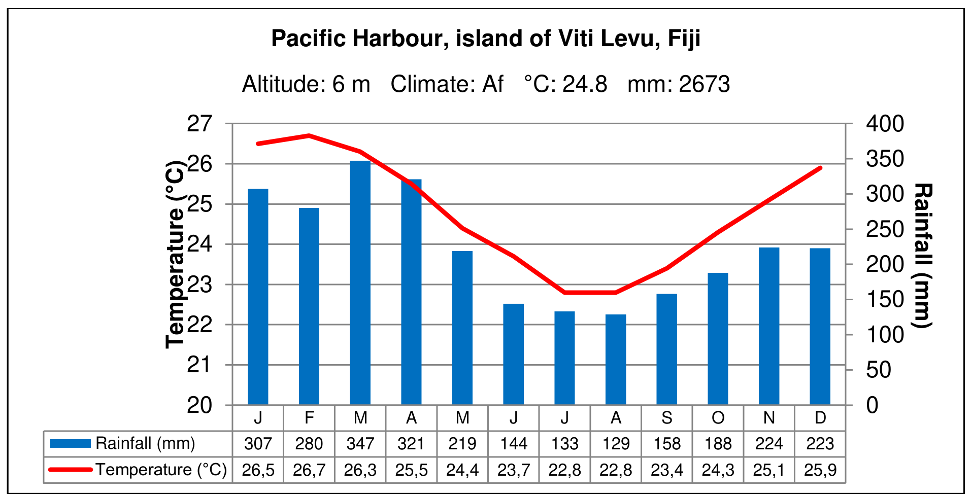
- 2. January to April
Решение
1. Answer: point marking
B (1m).
2. Answer: point marking
January to April (1m).
3. Answer: point marking
Any reasonable list of different triggers (not initial conditions like geology, topography (relief) – steepness of slopes or gravity etc.), each correct answer 0.5m.
Landslide is “Movement of a mass of rock, debris or earth down a slope” (slides, falls, flows, topple and (lateral) spread).
- Weathering.
- Heavy precipitation (rainfall, storms and tropical cyclones etc.).
- Hydrogeology (aquifers saturation, seepage, change in groundwater level, liquefaction etc.).
- Snowmelt (seasonal).
- Retreat of glaciers.
- Flooding.
- Fluvial erosion (undercutting of cliffs and banks by rivers etc.).
- Coastal erosion (wave action, tidal currents, wave currents; high winds – aeolian erosion).
- Slopes dried out and cleared by fire (excluding human induced fires).
- Earthquakes and its vibrations.
- Tectonic movements.
- Volcanic activity and eruptions.
- Tsunami.
- Previous landslides.
- Fall of a meteorite.
- The effect of global warming (perhaps not totally natural factor) was considered only in case of its direct influence explained (i.e. the retreat of glaciers, the melting of permafrost, increase of sea water, heavier and longer rainfalls etc.).
4. Answer: point marking
Any reasonable list of different triggers, each correct answer 0.5m.
- Removal of vegetation.
- Interference with or changes to natural drainage.
- Damming of water.
- Irrigation.
- Modification (cutting and filling) of slopes by development by construction of buildings, urbanisation etc.
- Modification (cutting and filling) of slopes by development by construction of roads, railways, tunnels etc.
- Vibrations from heavy traffic.
- Leaking pipes (water, sewer).
- Mining activities, blasting and excavation or displacement of rocks.
- In residential development, natural river beds are often filled with soil to make a flat ground. Such filing will make an unstable slope susceptible to earthquake-induced landslides even when the slope is very gentle.
- Inadequate agricultural practices (crop planting and animals grazing counted separately).
- Recreational activities (pressure on surface caused by uncontrolled trekking etc.).
- Climate changes caused by human activities (CO emission).
- Nuclear weapons testing blasts.
- War (bombing).
5. Answer: point marking
Any reasonable list of different damages no matter the category.
- Fatalities.
- Killing people and animals.
- Damage.
- Engulfing people, animals, crops and buildings causing injuries and damage to property.
- Cutting off all infrastructures: roads, power lines, pipes, and communication lines, leaving people stranded.
- Ruining economic viability including food gardens and cash cropping areas.
- Secondary effect.
- Alteration of the landscape. Landslides (debris avalanche) can create huge gaps in the vista and dam rivers, flooding surrounding areas and creating lakes.
- Landslide dam outburst floods. Failure of a landslide dam, which has trapped large volumes of water behind it, can cause catastrophic flooding downstream.
- Tsunamis. Large landslides underwater or into the sea may create tsunamis.
- Reef damage. Landslides cause severe soil erosion and deposit this sediment in rivers, which then carry it into the sea causing considerable damage to the surrounding coral reefs.
6. Answer: level marking
- No other remedy will yield better results than avoiding landslide-prone areas altogether by consulting engineering geologist or a geotechnical engineer to evaluate the potential for landslides and other geology-related problems.
Landslide may be prevented by stabilisation of slope. There are three basic approaches:
- Geometric methods, in which the geometry of the hillside slope is changed. Rock slope and soil slope geometric modifications will require different techniques.
- Hydrogeological methods, in which an attempt is made to lower the groundwater level or to reduce the water content of the material.
- Mechanical methods, in which attempts are made to increase the shear strength of the unstable mass or to introduce active external forces (e.g. anchors, rock or ground nailing) or passive external forces (e.g. structural wells, piles or reinforced ground) to oppose the destabilising forces.
Once constructed, remedial measures must be inspected and maintained. Lack of maintenance can cause renewed landslide movement.
- Preserving vegetation (reforestation):
- Trees, grasses, and vegetation can minimise the amount of water infiltrating into the soil, slow the erosion caused by surface-water flow, and remove water from the soil.
- Although vegetation alone cannot prevent or stop a landslide, removal of vegetation from a landslide-prone slope may initiate a landslide.
- Improving surface and subsurface drainage:
- Surface water should be diverted away from the landslide-prone region by channelling water in a lined drainage ditch or sewer pipe to the base of the slope but not to be allowed to pond.
- Ground water can be drained from the soil using trenches filled with gravel and perforated pipes or pumped water wells.
- Swimming pools, water lines, and sewers should be maintained to prevent leakage, and the watering of lawns and vegetation should be kept to a minimum.
- Clayey soils and shales have low hydraulic conductivity and can be difficult to drain.
- Constructing piles and retaining walls (terraces, benches):
- (Friction) piles (metal beams, as wooden beams and telephone poles are not recommended for use as piles because they lack strength and can rot) are fixed to extend into a competent rock layer below the landslide.
- Retaining walls can be constructed by adding lagging (metal, concrete, or wooden beams) horizontally between the piles.
- Such walls can be further strengthened by adding tiebacks and buttressing beams.
- Retaining walls also are constructed of concrete, cinder blocks, rock, railroad ties, or logs, but these may not be strong enough to resist landslide movement and could topple.
- Sheet piling.
- Rock fall protection:
- Loose blocks of rock are attached to bedrock with rock bolts, long metal rods that are anchored in competent bedrock and are threaded on the outside for large nuts.
- Geo Grid, shotcrete.
- Removal and replacement (altering the slope gradient):
- Landslide-prone soil and rock can be removed and replaced with stronger materials, such as silty or sandy soils.
- Must include measures to prevent continued weathering of the remaining rock.
- Legal approach:
- Land use regulation, abstaining from building houses / practicing agriculture etc. in landslide-prone places.
Оригинал в Архива: WRITTEN RESPONSE TEST QUESTION AND ANSWER BOOK _2016iGeo.pdf · официални решения: WRITTEN RESPONSE TEST MARKING SCHEME_2016iGeo.pdf