iGeo 2016, Писмен тест — Задача 2. Section B: Tsunamis
13th International Geography Olympiad — Beijing, China — 16–22 August 2016 — Written Response Test — Question and Answer Booklet · 16 август 2016 г. · 15 т.
Cover of the Question and Answer Booklet
13th International Geography Olympiad
Beijing, China
16–22 August 2016
Written Response Test
Question and Answer Booklet
Do NOT open the Booklet before instructed to do so by a supervisor.
Name: ........ Team: ........
iGeo student number: ........
Instructions for Students
Fill in your name, team and iGeo student number on the front page of this Question and Answer Booklet.
Fill in your iGeo student number in the boxes on top of the pages in this Booklet.
This test consists of 6 Sections.
The maximum total mark is 90.
The mark for each question is given in the margin at the beginning of the question.
There is a maximum of 15 marks for each Section.
- Answer all questions in the spaces provided in this Booklet in English.
Keep the left margin free for markers.
Please write clearly.
Please use blue (or black) pen, not pencil.
Check the backs of pages as questions are printed on both sides of a page.
There are blank pages which you can use as additional space for your notes.
Please cross through any notes so that we know they are not part of your answers.
If you use these pages for answers, please label them clearly with the Section and question number (e.g. A1).
Where appropriate, please write sentences or phrases not single words.
Give only the required number of answers (reasons, examples, etc.).
For instance, if the question asks for 2 reasons and you give more than 2, only the first 2 reasons will be marked.
The Resource Booklet contains Figures referred to in this Booklet.
You may use a calculator during the test.
Time: 180 minutes for students not educated in English (+10 minutes reading time),
150 minutes for students educated in English (+10 minutes reading time).
- Students not educated in English are allowed to use bilingual dictionaries during the test.
Good luck!
Written Response Test
Contributions from: Belgium, China–Hong Kong, Czech Republic, Indonesia, Poland, Singapore
Committee Convenor: Anu Printsmann (Estonia)
Deputy: Dubravka Spevec (Croatia)
Editors: Jason Flowers (USA), Celestine Hang (Singapore), Alexey Naumov (Russia)
Director of Tests: Susan Lomas (UK)
Booklet layout
Every answer page carries a box „Student number:“ at the top. Pages 5, 6, 9, 16 and 20 end with „This Section continues on the next page.“ Pages 14 and 18 print only:
This page is intentionally blank (you can use it for your notes (please cross them through afterwards) or for answers, which are clearly labelled with the Section and question number).
The booklet ends with „end ■“ on page 21.
Cover of the Marking Scheme
13th International Geography Olympiad
Beijing, China
16–22 August 2016
Written Response Test
Marking Scheme
Instructions for Markers
Check if the iGeo student numbers are on each sheet (on odd pages) before dividing up the Test.
This test consists of 6 Sections.
The maximum total mark is 90.
The mark for each question is given in the margin at the beginning of the question.
There is a maximum of 15 marks for each Section.
- One whole Section per marker and double-checker.
Some lengthy (more than 2 pages) Sections may be divided for two marker-pairs.
- Get the hang of the full range of answers by reading through a few papers with your co-marker before you start your marking.
You can mark together, or after establishing a consensus on how to mark for thoroughness and consistency, act as each other’s double-checkers by marking half of the test and then swapping the pile.
We strongly recommend whenever in doubt, consult your marking partner and, if appropriate, one of the designated Moderators – Anu or Dubravka.
Please develop your own marking/correcting notation system (using +/-, x/0, √ marks), underlining, comments etc. to ease double-checking and sample marking.
These answers are not exhaustive. Credit any relevant answer.
Check whether the answer continues outside the designated area, in the margins or as clearly marked on blank pages.
No credits will be given to answers in the Resource Booklet.
The Test uses two marking systems: point and level marking.
Half marks can only be given where indicated as the total of 90 marks will yield only 40% of the total olympiad result.
Mark only the required number of answers (reasons, examples etc.).
For instance, if the question asks for 2 reasons and there is more than 2, only the first 2 reasons should be marked.
- Put your final mark next to the question number in the column on the left – it eases the work of the person who has to put the numbers into MS Excel.
Please write your numbers clearly.
Please write down any inconsistencies of the Marking Scheme and additional answers or answers not accepted and hand them in after marking to improve the final Marking Scheme.
The Moderators (Anu and Dubravka) will sample the marking of all teams.
Written Response Test
Contributions from: Belgium, China–Hong Kong, Czech Republic, Indonesia, Poland, Singapore
Committee Convenor: Anu Printsmann (Estonia)
Deputy: Dubravka Spevec (Croatia)
Editors: Jason Flowers (USA), Celestine Hang (Singapore), Alexey Naumov (Russia)
Director of Tests: Susan Lomas (UK)
Условие
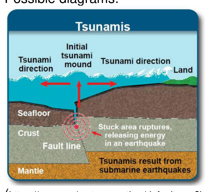
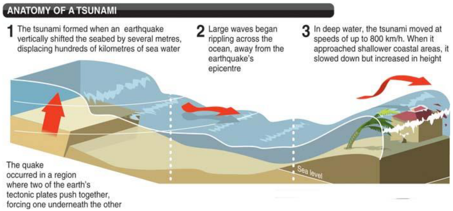
1. Draw an annotated diagram(s) to show how a tsunami can be caused by an earthquake. [4 т.]
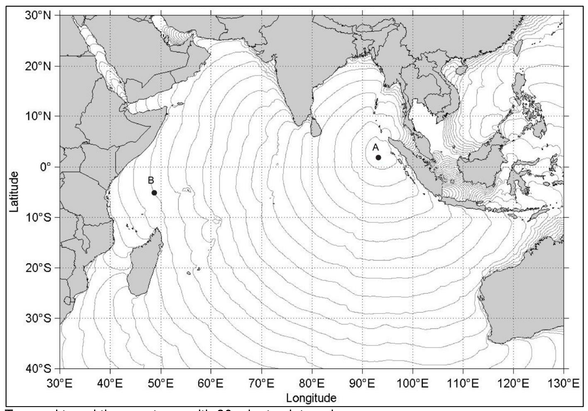
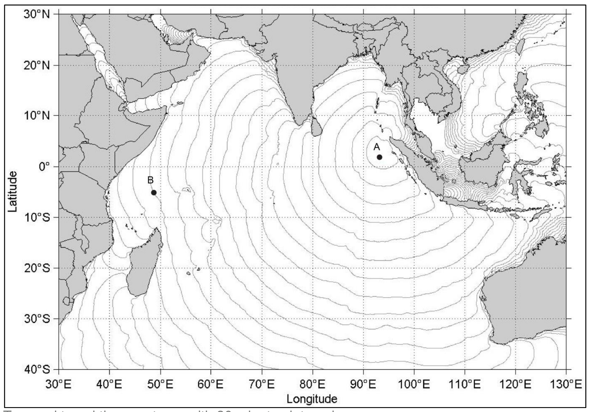
2. Study the figure below: Tsunami travel time contours with 30 minutes interval.
a) Provide the coordinates of the point A.
b) If the tsunami occurred at 06:57 GMT at the location marked by the point A, what time would it reach point B on the map? [2 т.]
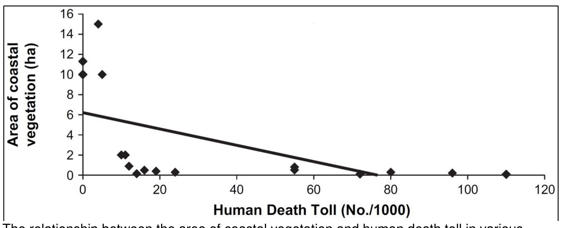
3. Study the figure below: The relationship between the area of coastal vegetation and human death toll in various districts in Tamil Nadu, India in the wake of the Boxing Day Tsunami of 2004.
Describe the relationship between the area of coastal vegetation and human death toll. [2 т.]
4. Explain 2 ways in which the establishment or maintenance of coastal vegetation can aid in tsunami hazard management. [4 т.]
5. In 2004 the Boxing Day Tsunami waves brought illegally dumped radioactive nuclear waste onto Somalia’s coast.
Explain its effect for Somalia’s economy. [3 т.]
Отговори
- 2. a) 2–3°N, 93–94°E; b) 13:57 GMT
Решение
1. Answer: point marking
- Submarine earthquake (1m).
- Displaced column of water (1m).
- Increasing wave height (and lower speed) towards shore (1m).
- Annotation (different from labelling) (1m).
Possible diagrams:
2. Answer: point marking
a) 2–3°N, 93–94°E (1m).
b) 13:57 GMT (1m).
3. Answer: point marking
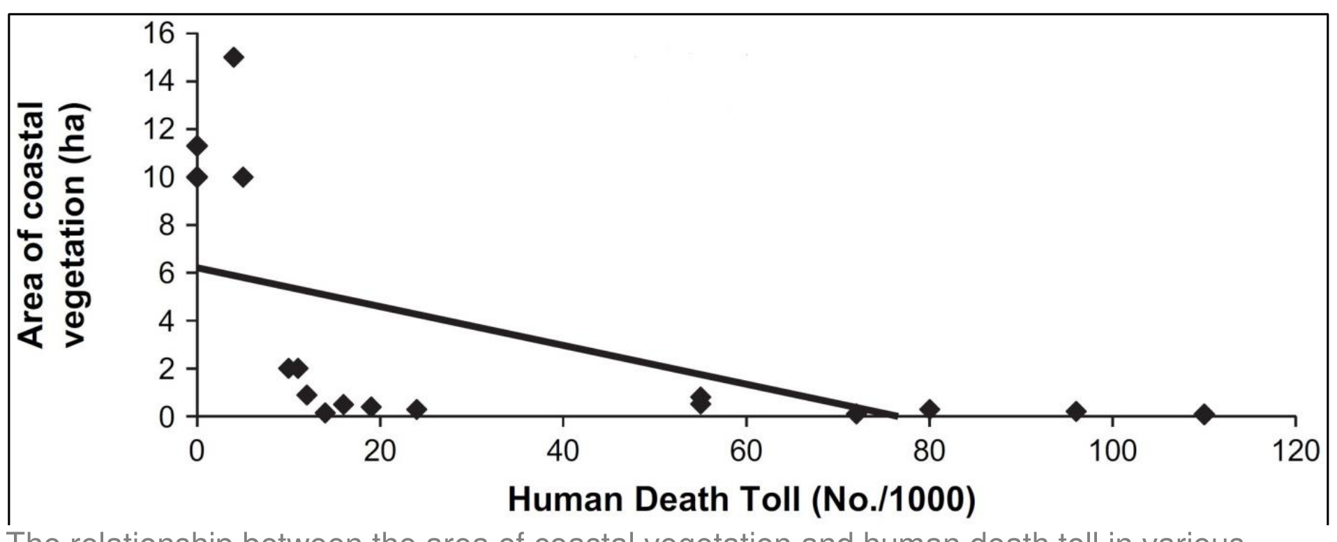
- Main point: inverse relationship: greater the area of coastal vegetation, the lesser the human death toll from the correlation line on the graph (1m).
- Any additional reasonable comment with referring to specific numbers where necessary (1m).
- The correlation line does not describe well the overall situation where there are three clusters of districts from left to right:
- large areas (ca 10–15 ha) with coastal vegetation corresponds with ca 0–5 deaths/thousand,
- areas of ca 0–2 ha corresponds with ca 10–25 deaths/thousand,
- areas of ca 0–2 ha can corresponds with also up to ca 55–110 deaths/thousand.
- Anomaly: the death toll on very small areas (ca 0–2 ha) of coastal vegetation has a very wide span ranging from ca 10–110 deaths/thousand, whereas the death toll on larger areas (> 10 ha) varies much less, ranging from ca 0–5 deaths/thousand against reason.
- For clearer and more comprehensive results the districts with ca 2–10 ha of coastal vegetation could have been included but perhaps there were not any.
- The graph does not say anything about the background and comparability of districts used, i.e. were they of the same areal size, was the population density the same in all areas (concentrated vs. dispersed settlements), were the district from the same distance from the sea, are these from the same height etc.
4. Answer: level marking
- Reflect and resist tsunami energy, reduce inundation depth, inundation area and tsunami current.
- Stop driftwood and other materials moved by tsunamis, and to prevent the secondary damage by driftwood impact.
- Prevent people from being washed out to sea.
- Reduce erosion of beaches and dunes which also act as barriers against tsunamis.
- Mangroves’ wave attenuation is because of the mangrove forests function as sinks for the suspended sediments.
5. Answer: level marking
Significant pollution of coastal waters ruined local marine life (ecosystem) causing fishing industry which played an important role in Somalia’s economy to collapse resulting in loss of jobs and income.
- Due to collapsing of fishing industry many Somali men became pirates.
- Health risk for workforce.
- Spending money on cleaning radioactive nuclear waste is reducing the budget for economic development.
- Fewer tourists bring less income.
- Reduce the foreign investment.
Оригинал в Архива: WRITTEN RESPONSE TEST QUESTION AND ANSWER BOOK _2016iGeo.pdf · официални решения: WRITTEN RESPONSE TEST MARKING SCHEME_2016iGeo.pdf