iGeo 2016, Писмен тест — Задача 3. Section C: Phewa Lake in Nepal
13th International Geography Olympiad — Beijing, China — 16–22 August 2016 — Written Response Test — Question and Answer Booklet · 16 август 2016 г. · 15 т.
Cover of the Question and Answer Booklet
13th International Geography Olympiad
Beijing, China
16–22 August 2016
Written Response Test
Question and Answer Booklet
Do NOT open the Booklet before instructed to do so by a supervisor.
Name: ........ Team: ........
iGeo student number: ........
Instructions for Students
Fill in your name, team and iGeo student number on the front page of this Question and Answer Booklet.
Fill in your iGeo student number in the boxes on top of the pages in this Booklet.
This test consists of 6 Sections.
The maximum total mark is 90.
The mark for each question is given in the margin at the beginning of the question.
There is a maximum of 15 marks for each Section.
- Answer all questions in the spaces provided in this Booklet in English.
Keep the left margin free for markers.
Please write clearly.
Please use blue (or black) pen, not pencil.
Check the backs of pages as questions are printed on both sides of a page.
There are blank pages which you can use as additional space for your notes.
Please cross through any notes so that we know they are not part of your answers.
If you use these pages for answers, please label them clearly with the Section and question number (e.g. A1).
Where appropriate, please write sentences or phrases not single words.
Give only the required number of answers (reasons, examples, etc.).
For instance, if the question asks for 2 reasons and you give more than 2, only the first 2 reasons will be marked.
The Resource Booklet contains Figures referred to in this Booklet.
You may use a calculator during the test.
Time: 180 minutes for students not educated in English (+10 minutes reading time),
150 minutes for students educated in English (+10 minutes reading time).
- Students not educated in English are allowed to use bilingual dictionaries during the test.
Good luck!
Written Response Test
Contributions from: Belgium, China–Hong Kong, Czech Republic, Indonesia, Poland, Singapore
Committee Convenor: Anu Printsmann (Estonia)
Deputy: Dubravka Spevec (Croatia)
Editors: Jason Flowers (USA), Celestine Hang (Singapore), Alexey Naumov (Russia)
Director of Tests: Susan Lomas (UK)
Booklet layout
Every answer page carries a box „Student number:“ at the top. Pages 5, 6, 9, 16 and 20 end with „This Section continues on the next page.“ Pages 14 and 18 print only:
This page is intentionally blank (you can use it for your notes (please cross them through afterwards) or for answers, which are clearly labelled with the Section and question number).
The booklet ends with „end ■“ on page 21.
Cover of the Marking Scheme
13th International Geography Olympiad
Beijing, China
16–22 August 2016
Written Response Test
Marking Scheme
Instructions for Markers
Check if the iGeo student numbers are on each sheet (on odd pages) before dividing up the Test.
This test consists of 6 Sections.
The maximum total mark is 90.
The mark for each question is given in the margin at the beginning of the question.
There is a maximum of 15 marks for each Section.
- One whole Section per marker and double-checker.
Some lengthy (more than 2 pages) Sections may be divided for two marker-pairs.
- Get the hang of the full range of answers by reading through a few papers with your co-marker before you start your marking.
You can mark together, or after establishing a consensus on how to mark for thoroughness and consistency, act as each other’s double-checkers by marking half of the test and then swapping the pile.
We strongly recommend whenever in doubt, consult your marking partner and, if appropriate, one of the designated Moderators – Anu or Dubravka.
Please develop your own marking/correcting notation system (using +/-, x/0, √ marks), underlining, comments etc. to ease double-checking and sample marking.
These answers are not exhaustive. Credit any relevant answer.
Check whether the answer continues outside the designated area, in the margins or as clearly marked on blank pages.
No credits will be given to answers in the Resource Booklet.
The Test uses two marking systems: point and level marking.
Half marks can only be given where indicated as the total of 90 marks will yield only 40% of the total olympiad result.
Mark only the required number of answers (reasons, examples etc.).
For instance, if the question asks for 2 reasons and there is more than 2, only the first 2 reasons should be marked.
- Put your final mark next to the question number in the column on the left – it eases the work of the person who has to put the numbers into MS Excel.
Please write your numbers clearly.
Please write down any inconsistencies of the Marking Scheme and additional answers or answers not accepted and hand them in after marking to improve the final Marking Scheme.
The Moderators (Anu and Dubravka) will sample the marking of all teams.
Written Response Test
Contributions from: Belgium, China–Hong Kong, Czech Republic, Indonesia, Poland, Singapore
Committee Convenor: Anu Printsmann (Estonia)
Deputy: Dubravka Spevec (Croatia)
Editors: Jason Flowers (USA), Celestine Hang (Singapore), Alexey Naumov (Russia)
Director of Tests: Susan Lomas (UK)
Условие
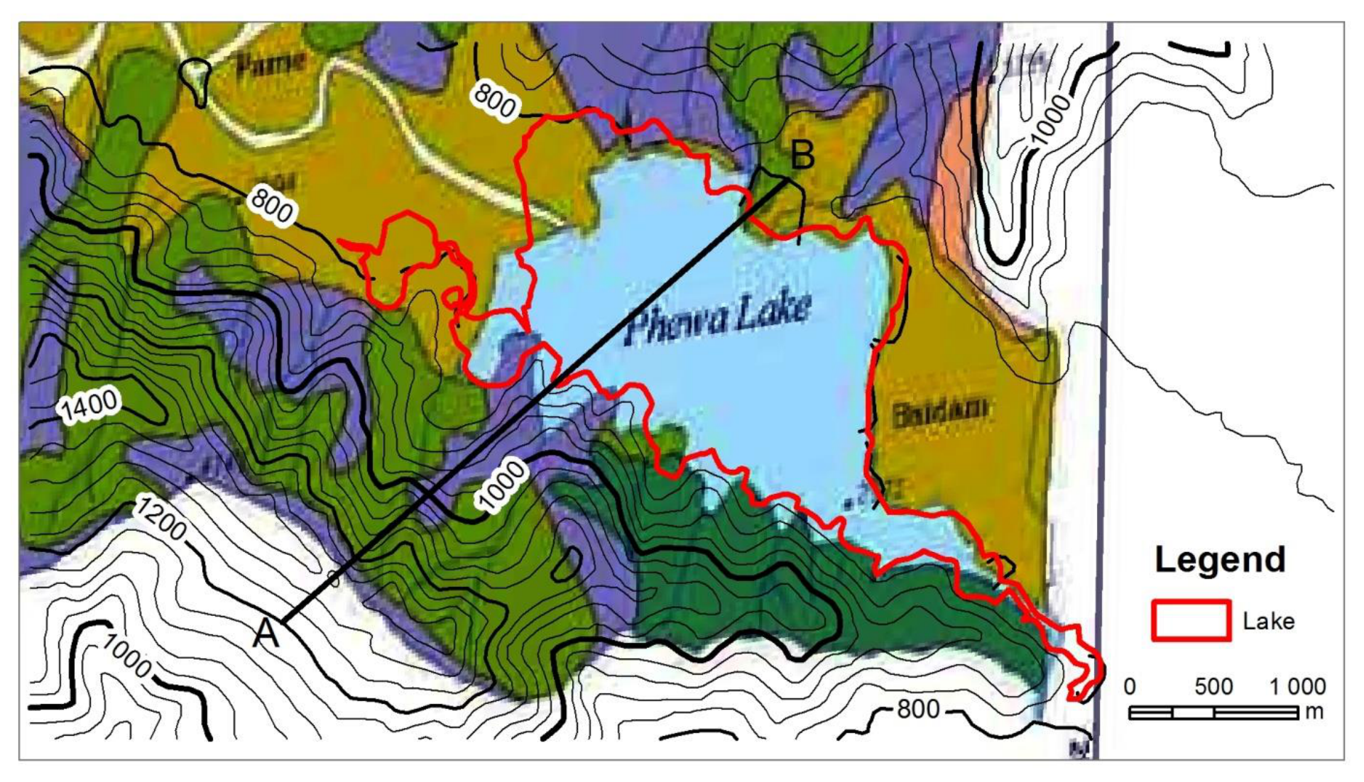
1. Study Resource Booklet Figure C1: Height contour map of the region around Phewa Lake.
Estimate the height of the surface of the lake. [1 т.]
2. Study Resource Booklet Figure C1: Height contour map of the region around Phewa Lake.
Estimate the length of the perimeter of Phewa Lake. [1 т.]
3. Study Resource Booklet Figures C1: Height contour map of the region around Phewa Lake and
C2: A land use map of the Phewa Lake Catchment Area.
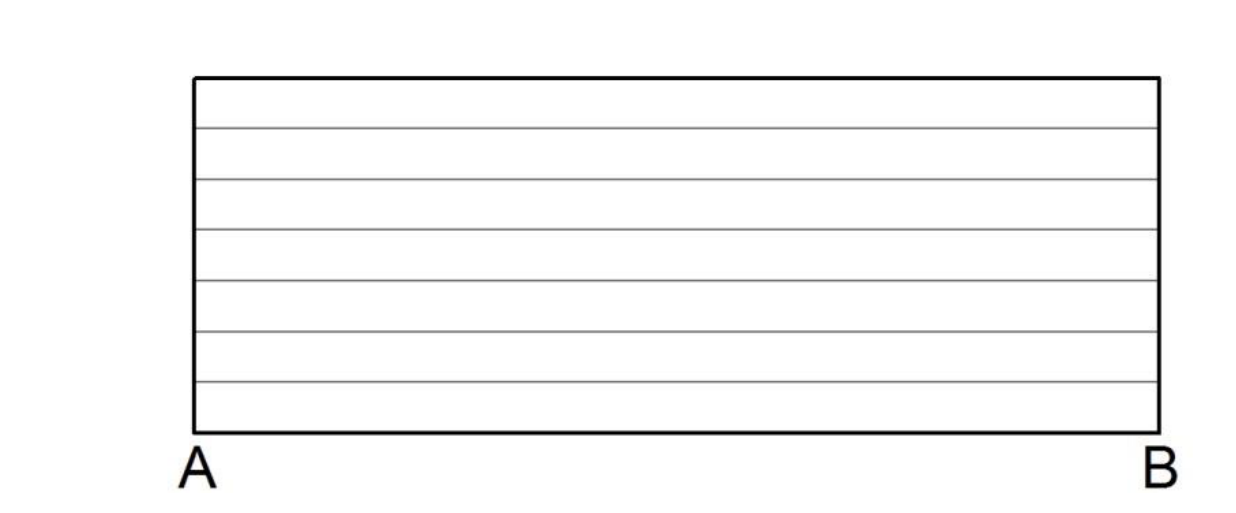
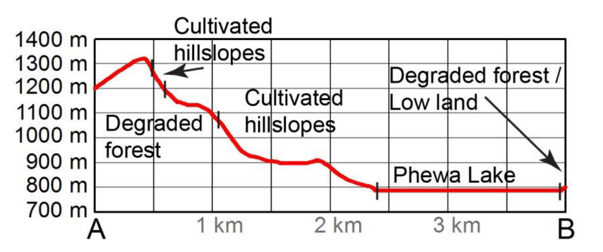
Draw a labelled profile of the transect A–B using both maps. [4 т.]
4. Study Resource Booklet Figure C3: Change in Phewa Lake area between 1988 and 2012.
Describe the changes in the area of Phewa Lake between 1988 and 2012. [2 т.]
5. Study Resource Booklet Figure C2: A land use map of the Phewa Lake Catchment Area.
Explain how the land use surrounding Phewa Lake can affect the lake in 2 ways. [4 т.]
6. Evaluate the impact of recreational development on Phewa Lake area. [3 т.]
Решение
1. Answer: point marking
Any number or range between 761–800 m above sea level as the elevation lines have 40 m height difference the exact height of the water surface cannot be detected. Around or ±800 m above sea level also marked as correct answer, as the lake crosses the 800 m isoline at some points (1m). Answers above 820 m above sea level marked 0m.
2. Answer: point marking
Breaks at: 17 km and 21 km (both including), so: 17 ≤ x ≥ 21 km (1m).
3. See next page.
4. Answer: point marking
- Lake reduced in size (0.5m), approximately 300,000–450,000 or 5–10% (0.5m).
- Separation into two lakes; not constant shrinking, as the period 1988–1999/2003 shows larger shrinking rate; reduced on the western side of the lake (1m), “on the left” (0m).
5. Answer: level marking
- Land use (0.5m),
- affect (0.5m),
- link (reason, explanation, process) between land use and affect (1m).
Examples:
- Surrounding degraded forests may eventually lead to more runoff and sedimentation in the lake, thus increasing the height and size of the lake.
- Surrounding cultivated hill slopes may lead to runoff of fertilizer and eutrophication in the lake, killing off the biodiversity in the lake.
- The dense protected forest on the southeastern shore can have a positive effect on the water quality of the lake.
3. Answer: point marking
- Elevation (shape) of the profile line (2m), maximum of 1 minor mistake in profile (1m).
- Labelling the land use and lake (1m).
- Proper labelling of units of Y-axis (1m).
Notes:
- The correct height of the surface of the lake is 761–800 m above sea level as the elevation lines have 40 m height difference the exact height of the water surface cannot be detected (see question C1).
- The two maps are from different years, projections and scale – but this is real life geography of not matching maps and students cannot use georeferencing and even then the shape of the lake is not perfect (see below). Allow flexibility.
- If the profile is too way off (e.g. no hill/lake recognisable at all), no points are given for land use and Y-axis.
- The vertical lines and kilometres are only for informative reasons for markers.
6. Answer: level marking
- Impact can be evaluated based on the potential problems and opportunities (positive and negative impact) of this development for the area and its inhabitants – a holistic appraisal of the impact.
- Additionally, responses could include a range of impact – economic benefits to the residents, environmental impact on the lake or the clearance of forest for hotels or roads with more people etc.
- It could also include a consideration of time period (duration/timing) i.e. in the long term and the short term, the scale of impact, and relevance to the lake and its environment, including recognition that is it in a developing country.
Examples:
- 1m: at least two well explained reasons of which one has to be social/economic. List of impacts is maximum of 1m.
- 2m: + classified/labelled (environmental, economic, social, ecological etc.) impact from different aspects. Keywords: On the other hand… / However… / But… / Positive and negative effects.
- 3m: + comparison or weighted conclusion, or in depth geographical analysis with also secondary impact / different scales / different time scale (long term – short term), or consideration of broader context.
Оригинал в Архива: WRITTEN RESPONSE TEST QUESTION AND ANSWER BOOK _2016iGeo.pdf · официални решения: WRITTEN RESPONSE TEST MARKING SCHEME_2016iGeo.pdf