iGeo 2016, Писмен тест — Задача 6. Section F: Urban Theories and Development
13th International Geography Olympiad — Beijing, China — 16–22 August 2016 — Written Response Test — Question and Answer Booklet · 16 август 2016 г. · 15 т.
Cover of the Question and Answer Booklet
13th International Geography Olympiad
Beijing, China
16–22 August 2016
Written Response Test
Question and Answer Booklet
Do NOT open the Booklet before instructed to do so by a supervisor.
Name: ........ Team: ........
iGeo student number: ........
Instructions for Students
Fill in your name, team and iGeo student number on the front page of this Question and Answer Booklet.
Fill in your iGeo student number in the boxes on top of the pages in this Booklet.
This test consists of 6 Sections.
The maximum total mark is 90.
The mark for each question is given in the margin at the beginning of the question.
There is a maximum of 15 marks for each Section.
- Answer all questions in the spaces provided in this Booklet in English.
Keep the left margin free for markers.
Please write clearly.
Please use blue (or black) pen, not pencil.
Check the backs of pages as questions are printed on both sides of a page.
There are blank pages which you can use as additional space for your notes.
Please cross through any notes so that we know they are not part of your answers.
If you use these pages for answers, please label them clearly with the Section and question number (e.g. A1).
Where appropriate, please write sentences or phrases not single words.
Give only the required number of answers (reasons, examples, etc.).
For instance, if the question asks for 2 reasons and you give more than 2, only the first 2 reasons will be marked.
The Resource Booklet contains Figures referred to in this Booklet.
You may use a calculator during the test.
Time: 180 minutes for students not educated in English (+10 minutes reading time),
150 minutes for students educated in English (+10 minutes reading time).
- Students not educated in English are allowed to use bilingual dictionaries during the test.
Good luck!
Written Response Test
Contributions from: Belgium, China–Hong Kong, Czech Republic, Indonesia, Poland, Singapore
Committee Convenor: Anu Printsmann (Estonia)
Deputy: Dubravka Spevec (Croatia)
Editors: Jason Flowers (USA), Celestine Hang (Singapore), Alexey Naumov (Russia)
Director of Tests: Susan Lomas (UK)
Booklet layout
Every answer page carries a box „Student number:“ at the top. Pages 5, 6, 9, 16 and 20 end with „This Section continues on the next page.“ Pages 14 and 18 print only:
This page is intentionally blank (you can use it for your notes (please cross them through afterwards) or for answers, which are clearly labelled with the Section and question number).
The booklet ends with „end ■“ on page 21.
Cover of the Marking Scheme
13th International Geography Olympiad
Beijing, China
16–22 August 2016
Written Response Test
Marking Scheme
Instructions for Markers
Check if the iGeo student numbers are on each sheet (on odd pages) before dividing up the Test.
This test consists of 6 Sections.
The maximum total mark is 90.
The mark for each question is given in the margin at the beginning of the question.
There is a maximum of 15 marks for each Section.
- One whole Section per marker and double-checker.
Some lengthy (more than 2 pages) Sections may be divided for two marker-pairs.
- Get the hang of the full range of answers by reading through a few papers with your co-marker before you start your marking.
You can mark together, or after establishing a consensus on how to mark for thoroughness and consistency, act as each other’s double-checkers by marking half of the test and then swapping the pile.
We strongly recommend whenever in doubt, consult your marking partner and, if appropriate, one of the designated Moderators – Anu or Dubravka.
Please develop your own marking/correcting notation system (using +/-, x/0, √ marks), underlining, comments etc. to ease double-checking and sample marking.
These answers are not exhaustive. Credit any relevant answer.
Check whether the answer continues outside the designated area, in the margins or as clearly marked on blank pages.
No credits will be given to answers in the Resource Booklet.
The Test uses two marking systems: point and level marking.
Half marks can only be given where indicated as the total of 90 marks will yield only 40% of the total olympiad result.
Mark only the required number of answers (reasons, examples etc.).
For instance, if the question asks for 2 reasons and there is more than 2, only the first 2 reasons should be marked.
- Put your final mark next to the question number in the column on the left – it eases the work of the person who has to put the numbers into MS Excel.
Please write your numbers clearly.
Please write down any inconsistencies of the Marking Scheme and additional answers or answers not accepted and hand them in after marking to improve the final Marking Scheme.
The Moderators (Anu and Dubravka) will sample the marking of all teams.
Written Response Test
Contributions from: Belgium, China–Hong Kong, Czech Republic, Indonesia, Poland, Singapore
Committee Convenor: Anu Printsmann (Estonia)
Deputy: Dubravka Spevec (Croatia)
Editors: Jason Flowers (USA), Celestine Hang (Singapore), Alexey Naumov (Russia)
Director of Tests: Susan Lomas (UK)
Условие
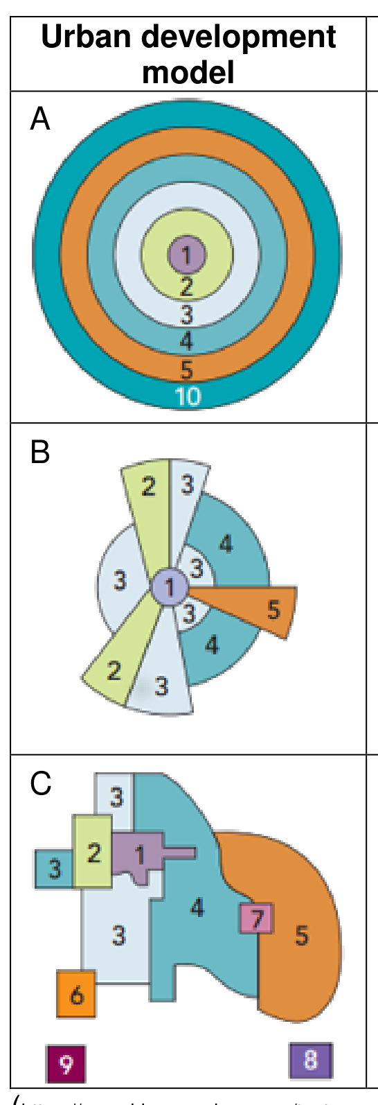
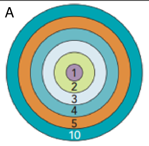
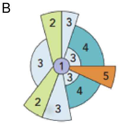
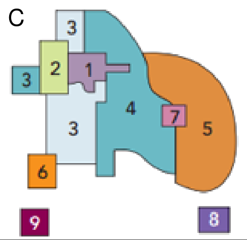
1. Study the figures A–C below: Urban development models.
The numbers and shades refer to different land uses.
Describe the urban development in each of the 3 models. [3 т.]
2. Study Resource Booklet Figure F1: A photo of Barcelona, Spain.
a) Which area/zone (1–10) in the urban development models (see previous question) does this picture correspond to?
b) What are 3 main characteristics of this area/zone? [2 т.]
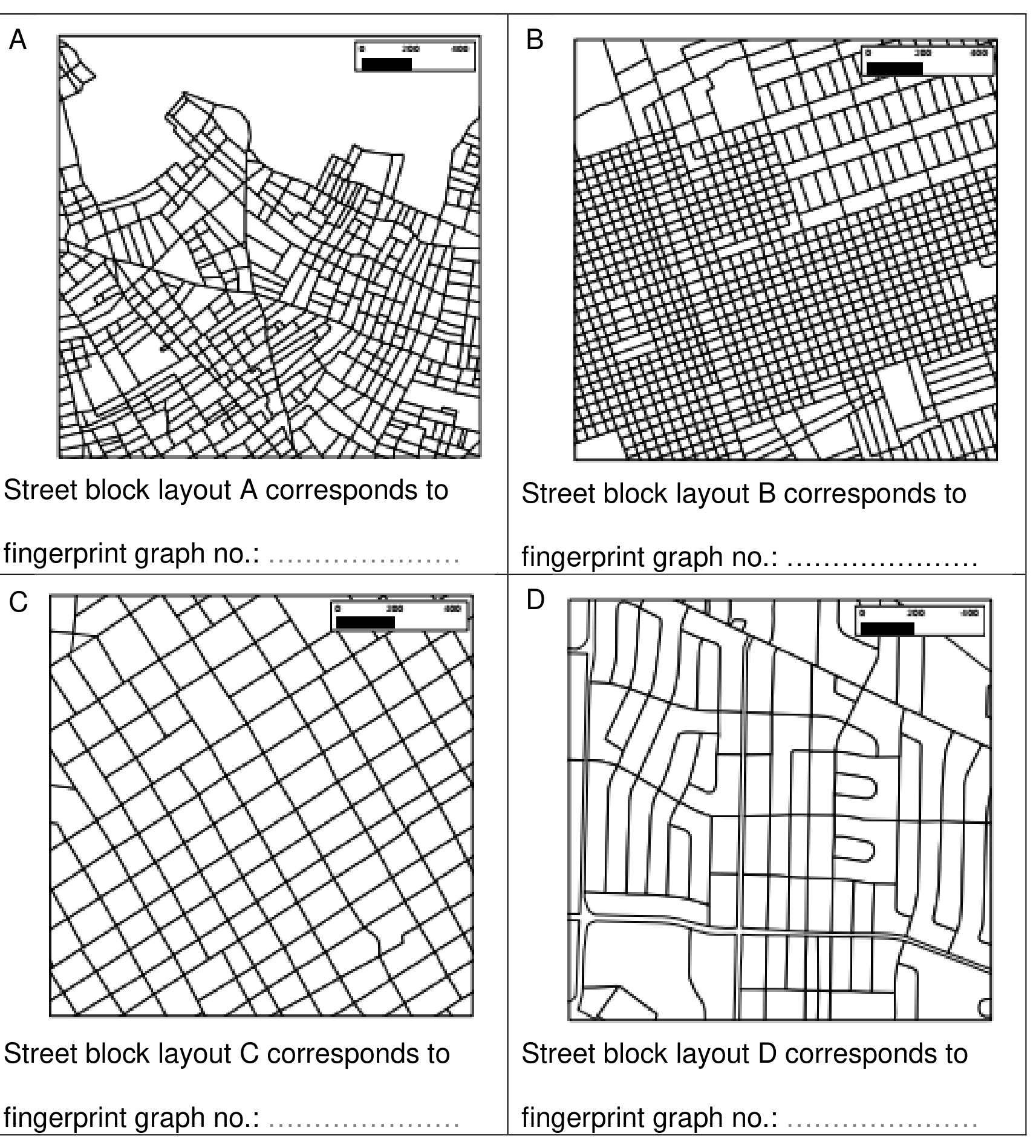
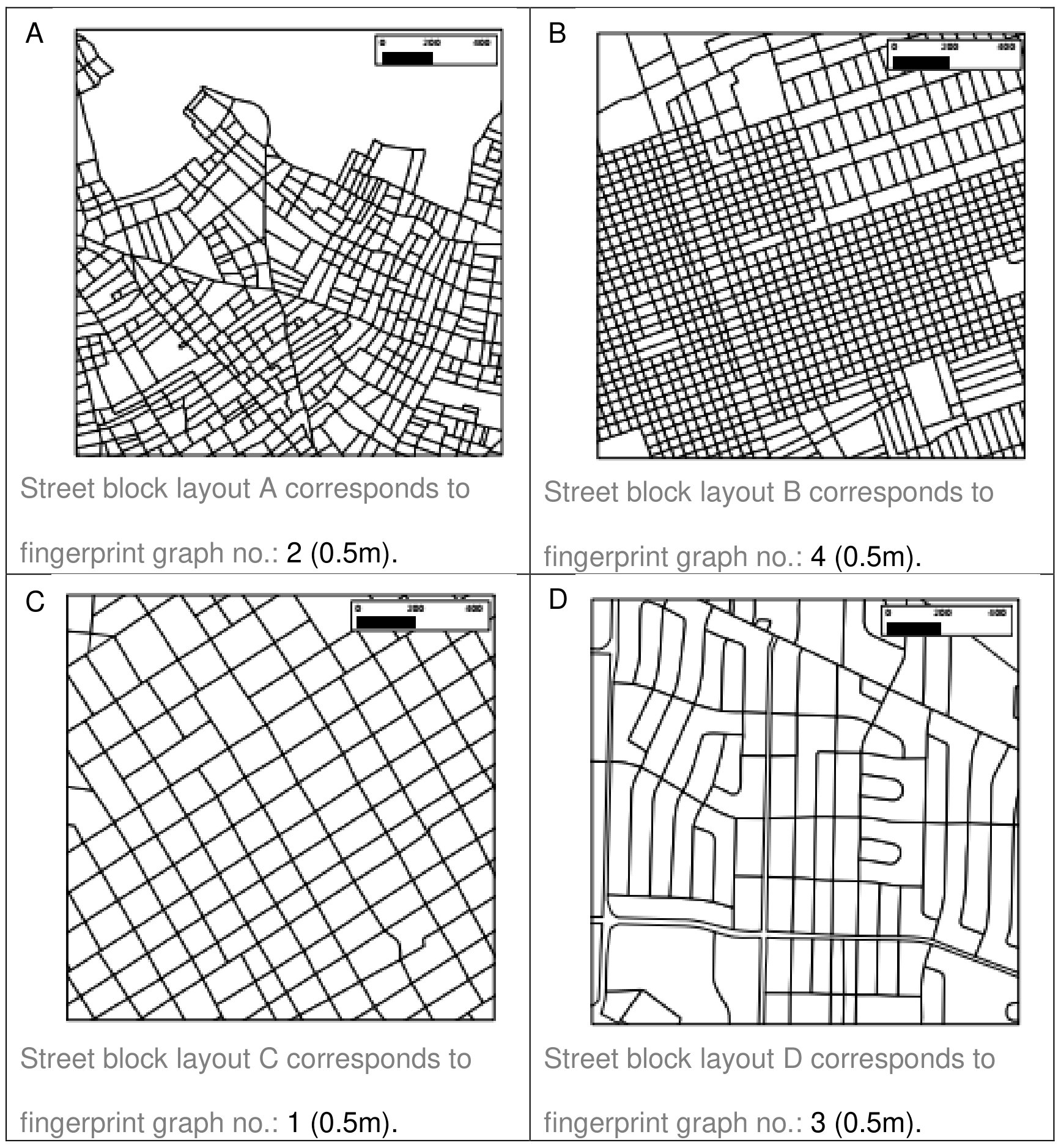
3. Study Resource Booklet Figure F2: Urban “fingerprints”.
Match the street block layouts (A, B, C and D) with the corresponding urban “fingerprints” graphs (1, 2, 3 and 4). [2 т.]
4. Discuss how urban (spatial) structure influences energy efficiency in cities. [4 т.]
5. The “smart city” concept of future urban development is being introduced in many countries.
Elaborate how this concept can be disadvantageous for cities? [4 т.]
Отговори
- 2. a) zone 1
- 3. A – 2, B – 4, C – 1, D – 3
Решение
1. Answer: point marking
| Urban development model | Description of urban development |
|---|---|
| A | (Concentric zone model by Burgess (1925)) – students do not have to name the authors or models. The city has expanded outwards in rings with different land uses, whereas, CBD (Old Town, City) is located in the center (1) and is surrounded by industry and low-income housing. Medium- and high-income housing are located peripherally (1m). |
| B | (Sector model by Hoyt (1939)) – students do not have to name the authors or models. The city core is still in the middle but different land uses are allowed for an outward progression of growth radially towards city periphery and open countryside, e.g. along transportation or communication lines/corridors/routes; less desirable city zones closer to centre can witness decaying housing (1m). |
| C | (Multiple nuclei model by Harris and Ullman (1945)) – students do not have to name the authors or models. Illustrates multimodal nature of urban development in possibly urban sprawl environment where the core loses its importance and new industrial parks and residential suburbs have been formed outside of the city possibly forming a new core or edge city (1m). |
2. Answer: point marking
a) “1” (0.5m).
b) Any reasonable list of different characteristics (3 x 0.5m = 1.5m).
- Higher urban density; good infrastructure, accessibility; newest technologies, design.
- Higher prices of land and/or rent; people with higher income work there.
- Higher concentration of offices and retail buildings; business rather than housing.
- Location of many government offices.
- Often site of the tallest buildings in the city; modern, posh outlook.
- Cultural diversity (multinational corporations) and functions (theatres, cinemas, etc.).
- Big daytime, limited night time population.
3. Answer: point marking
Each correct answer 0.5m (4 x 0.5m = 2m).
- Street block layout A corresponds to fingerprint graph no. 2 (0.5m).
- Street block layout B corresponds to fingerprint graph no. 4 (0.5m).
- Street block layout C corresponds to fingerprint graph no. 1 (0.5m).
- Street block layout D corresponds to fingerprint graph no. 3 (0.5m).
4. Answer: level marking
Urban form and transport systems are two major components of urban structure that influence energy efficiency in cities.
- Urban spatial structure determines energy demand and consumption (e.g. for transport and space heating/cooling in buildings) and opportunities for introducing alternative energy systems in urban areas (e.g. competitive public transport systems to reduce energy use).
- Dense, compact, diverse and concentrated cities contribute more to reduction of travel needs (mostly by car) and lower energy use for transport, and facilitate and favour the efficient use of energy (“green transport”).
- Dispersed urban settlements characterised by physical separation of activities and with longer commuting distances affects one's travel needs and therefore energy requirements for transport (more frequent private car usage).
5. Answer: level marking
- Concept can contribute negatively to even more social differences between the city inhabitants (larger gap between poor and rich).
- Using information technology (hi-tech methods) cities can/will become more expensive.
- It can contribute even more to corruption, even though it might just become more sophisticated.
- Using modern technology in city management can lead to city services being shut down or personal information being released (technology being used to spy on citizens).
- Possible “domino effect” – the fact that cities are bound to become increasingly connected could also mean that a failure in one sector could lead to problems in others.
Оригинал в Архива: WRITTEN RESPONSE TEST QUESTION AND ANSWER BOOK _2016iGeo.pdf · официални решения: WRITTEN RESPONSE TEST MARKING SCHEME_2016iGeo.pdf