iGeo 2017, Писмен тест — Задача 2. Section B: Climate and Weather
14th International Geography Olympiad — Belgrade, Serbia — 2–8 August 2017 — Written Response Test — Question and Answer Booklet · 2 август 2017 г. · 15 т.
Cover of the Question and Answer Booklet
14th International Geography Olympiad
Belgrade, Serbia
2–8 August 2017
WRITTEN RESPONSE TEST
Question and Answer Booklet
Name: ........ Team: ........
Student number: 1 4 _ _ _ _
Do NOT open the Booklet before instructed to do so by a supervisor.
Instructions for Students
Fill in your name, team and iGeo student number on the front page of this Question and Answer Booklet.
Fill in your iGeo student number in the boxes on top of the pages in this Booklet.
This test consists of 6 Sections.
The maximum total mark is 90.
The mark for each question is given in the margin at the beginning of the question.
There is a maximum of 15 marks for each Section.
- Answer all questions in the spaces provided in this Booklet in English.
Keep the left margin free for markers.
Please write clearly.
Please use blue (or black) pen, not pencil.
Check the backs of pages as questions are printed on both sides of a page.
There are blank pages which you can use as additional space for your notes.
Please cross through any notes so that we know they are not part of your answers.
If you use these pages for answers, please label them clearly with the Section and question number (e.g. A1).
Where appropriate, please write sentences or phrases not single words.
Give only the required number of answers (reasons, examples, etc.).
For instance, if the question asks for 2 reasons and you give more than 2, only the first 2 reasons will be marked.
- The Resource Booklet contains Figures referred to in this Booklet.
Do not write any of your answers in Resource Booklet.
You may use a calculator during the test.
Students not educated in English are allowed to use bilingual dictionaries during the test.
Time:
180 minutes for students not educated in English (+10 minutes reading time),
150 minutes for students educated in English (+10 minutes reading time).
Good luck!
Written Response Test
Contributions from: Australia, Germany, Indonesia, Japan, Mongolia, New Zealand, Switzerland, Taiwan/China–Taipei and UK
Committee Convenor: Dubravka Spevec (Croatia)
Deputy: Anu Printsmann (Estonia)
Editors: Shu Min (Celestine) Hang (Singapore) and Jacqueline Louise Richards (New Zealand)
Reviewers: Kath Berg (Australia) and Mark Higginbottom (UK)
Director of Tests: Susan Lomas (UK)
Booklet layout
The odd pages 3–17 carry a box „Student number: 14“ at the top; the marks of each question are printed in the left margin („2 m“, „4.5 m“ …). Pages 3, 11 and 12 end with „This Section continues on the next page.“ The booklet ends with „end ■“ on page 18.
Blank page 10 of the Question and Answer Booklet
This page is intentionally blank (you can use it for your notes (please cross them through afterwards) or for answers, which are clearly labelled with the Section and question number).
Blank page 14 of the Question and Answer Booklet
This page is intentionally blank (you can use it for your notes (please cross them through afterwards) or for answers, which are clearly labelled with the Section and question number).
Cover of the Marking Scheme
14th International Geography Olympiad
Belgrade, Serbia
2–8 August 2017
WRITTEN RESPONSE TEST
Marking Scheme
Instructions for Markers
Check if the iGeo student numbers are on each sheet (on odd pages) before dividing up the Test.
This test consists of 6 Sections.
The maximum total mark is 90.
The mark for each question is given in the margin at the beginning of the question.
There is a maximum of 15 marks for each Section.
- One whole Section per marker and double-checker.
Some lengthy (more than 2 pages) Sections may be divided for two marker-pairs.
- Get the hang of the full range of answers by reading through a few papers with your co-marker before you start your marking.
You can mark together (especially for level marking), or after establishing a consensus on how to mark for thoroughness and consistency, act as each other’s double-checkers by marking half of the test and then swapping the pile.
We strongly recommend whenever in doubt, consult your marking partner and, if appropriate, one of the designated Moderators – Dubravka or Anu.
Please develop your own marking/correcting notation system (using +/-, x/0, √ marks), underlining, comments etc. to ease double-checking and sample marking.
These answers here are not exhaustive. Credit any relevant answer.
Check whether the answer continues outside the designated area, in the margins or as clearly marked on blank pages.
No credits will be given to answers in the Resource Booklet.
The Test uses two marking systems: point and level marking.
Half marks can only be given where indicated as the total of 90 marks will yield only 40% of the total olympiad result.
Mark only the required number of answers (reasons, examples etc.).
For instance, if the question asks for 2 reasons and there is more than 2, only the first 2 reasons should be marked.
- Put your final mark next to the question number in the column on the left – it eases the work of the person who has to put the numbers into MS Excel.
Please write your numbers clearly.
Please write down any inconsistencies of the Marking Scheme, revisions and additional answers or answers not accepted on the Notes page at the end of the Booklet (e-mail is preferred) and hand them in after marking to improve the final Marking Scheme that will be uploaded to show the actual marking.
The Moderators (Dubravka and Anu) will sample the marking of all teams.
Command Terms for use in Written Response Test
| Terms | Meaning |
|---|---|
| Annotate | add labels with short comments to a diagram, map or photograph in order to describe or explain |
| Describe | give a factual statement of the distinctive features of something, e.g. for a landform, its shape, dimensions, composition, location (do not explain) |
| Discuss | give a thorough account from different points of view |
| Draw | make a clearly defined diagram, flowchart or map, and include labels |
| Explain | give a reason, a cause, an effect, a consequence for why or how something happens |
| Forecast | predict or estimate (a future event or trend) |
| Identify | name, select, point out something |
| Justify | provide sound reasons or evidence on which your response is based |
| Name | state or specify, using a word or words by which something is known |
| Outline | give the main points or general principles of something, omitting minor details, and usually emphasizing structure and relationships |
| Study | look closely at the details in |
| Suggest | put forward an idea or a reason |
| With the help of the information provided | base answer partly on information provided (refer to this material) and partly on own knowledge |
In level marking in order to credit higher marks the response has to cover a multi-perspective view with a range of factors/impacts from different spatial and temporal scales forming a thorough and well-elaborated account.
Written Response Test
Contributions from: Australia, Germany, Indonesia, Japan, Mongolia, New Zealand, Switzerland, Taiwan/China–Taipei and UK
Committee Convenor: Dubravka Spevec (Croatia)
Deputy: Anu Printsmann (Estonia)
Editors: Shu Min (Celestine) Hang (Singapore) and Jacqueline Louise Richards (New Zealand)
Reviewers: Kath Berg (Australia) and Mark Higginbottom (UK)
Director of Tests: Susan Lomas (UK)
Условие
1. Study Resource Booklet Table B1: The climate data for Addis Ababa, Ethiopia.
Draw a climate graph based on the data from the Table B1. [4,5 т.]

2. Study Resource Booklet Table B1: The climate data for Addis Ababa, Ethiopia and your climate graph for Addis Ababa, Ethiopia above.
Identify the wet (rainy) season and explain the main factors causing the rain in this season. [2,5 т.]
3. Study Resource Booklet Table B1: The climate data for Addis Ababa, Ethiopia and your climate graph for Addis Ababa, Ethiopia above.
Suggest 3 reasons for the monthly average temperature pattern (over a year) in Addis Ababa, Ethiopia. [3 т.]
4. Study Resource Booklet Figure B2: Surface pressure maps of 9–10 December 2014.
Explain the distribution of air pressure in the Northern Atlantic and over the European continent on 9–10 December 2014. [2 т.]
5. Study Resource Booklet Figure B2: Surface pressure maps of 9–10 December 2014.
Based on the observed movement of fronts, forecast the weather for 3 regions in Europe in the following 24 hours (11 December 2014). [3 т.]
Решение
1. Answer (point marking):
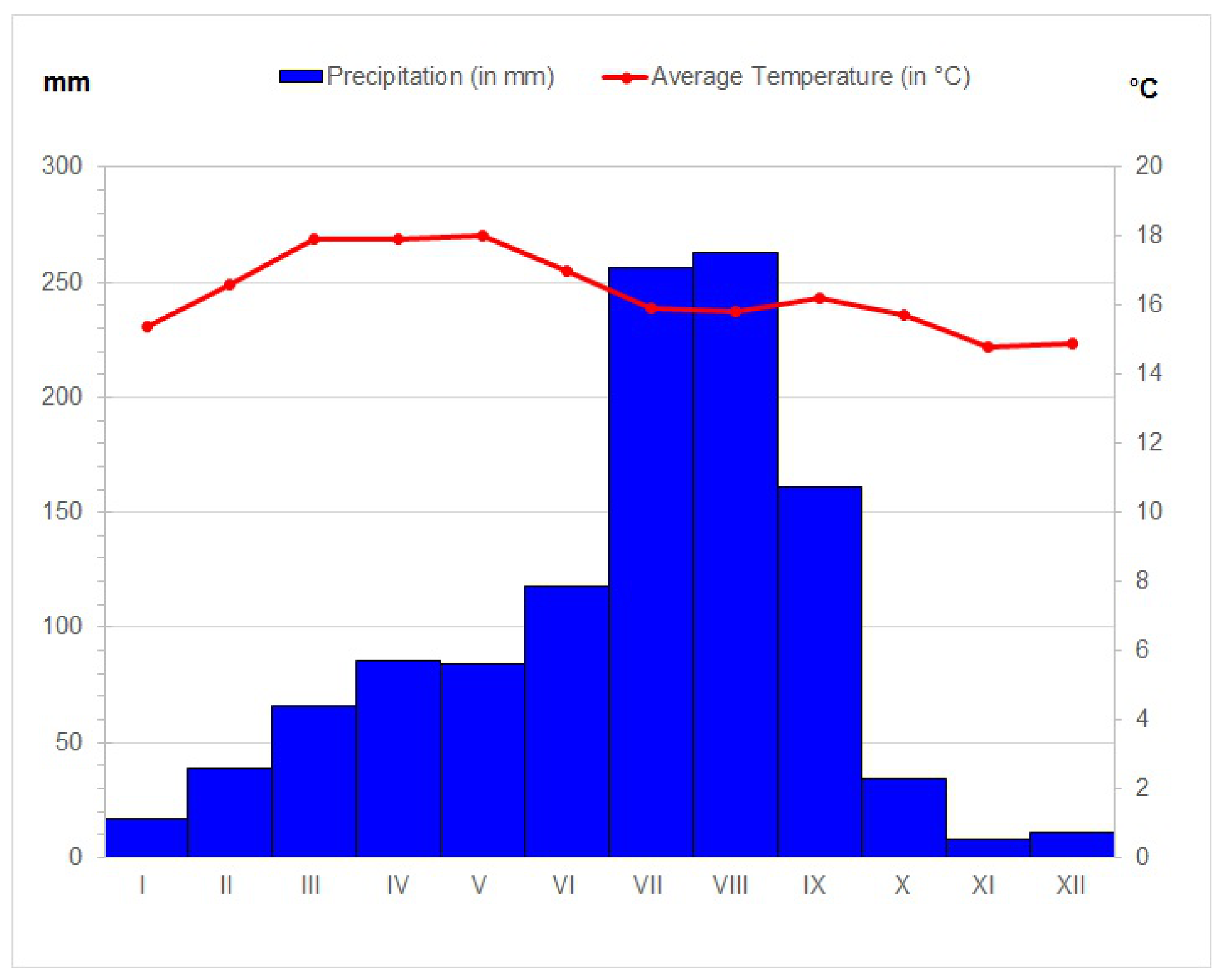
- Labelling X-axis (“January, February, March...” or “Jan, Feb, Mar…” or “J, F, M…” or “I, II, III…” or “1, 2, 3…”) (0.5 m).
- Labelling left Y-axis (“Precipitation in mm” or “mm” and numbers) (0.5 m).
- Labelling right Y-axis (“Average Temperature in °C” or “°C” and numbers) (0.5 m).
- Legend or key (0.5 m).
- Correctly drawn precipitation with columns (1 m).
- Correctly drawn temperature with line (1 m).
- Using blue colour for columns/precipitation and red for line/temperature (0.5 m).
2. Answer (point marking – 0.5 marks for correct season and 2 marks for correct factors):
Wet season: summer period (June/July–September).
The rainy season is caused by:
- Southeast trade winds after crossing the Equator become southwest monsoon winds that brings moisture from Indian Ocean.
- Inter-Tropical Convergence Zone (ITCZ) and the moist south-westerly monsoon flow from the Southern Hemisphere are the main rain producing structure.
- The onset and spatial distribution of rainfall are also found to follow the oscillation of the ITCZ and the intensity of the southern hemispheric anticyclones.
- Southerly/south-westerly cross-Equatorial moisture flow from the southern Indian Ocean and central tropical Africa.
- Warm and moist air mass is lifted over a mountain range of the Ethiopian Highlands, air cools, orographic clouds are formed and they serve as the main source of the large amount of precipitation (rain) in this area.
- The formation of heat flows over the Sahara and Arabian landmasses.
- Upper level Tropical Easterly Jet (TEJ) flowing over Ethiopia.
- Low-level jet (Somali jet).
3. Answer (point marking – 1 mark for each correct reason):
- Location near Equator means that temperatures are very constant from month to month (little variation in temperature throughout the year).
- Elevation moderates temperatures year-round.
- Maximum of temperature occur during the equinox.
- Average monthly temperatures are lower than in other tropical areas due to higher elevation (highlands).
- The winds that get pushed up and form clouds which further lowers the temperatures during the day.
- The lowest average monthly temperatures are during wet (rainy) season because of increased cloudiness which decreases insolation.
4. Answer (point marking – 1 mark for explaining land and sea air pressure system difference, 1 mark for polar front and other influencing circumstances):
- During winter (December) on the Northern Hemisphere in northern Atlantic Ocean (between Greenland and Iceland) area of low-pressure (known as Icelandic Low) is formed due to the fact that in winter the sea is cooling more slowly than the continent and due to the warm Gulf Stream (higher temperatures).
- The low pressure system near Iceland exists because of the polar front – where mild mid-latitude and frigid polar air run into each other. As the two air masses meet, air rises.
- Over Europe in winter forms an area of high air pressure (known as Siberian High or Siberian Anticyclone) because the continent is cooling much faster than the sea/ocean.
5. Answer (point marking – 1 mark for each correct forecast):
- Over southwestern (Iberian peninsula) and southern (Mediterranean) Europe is high-pressure and these areas will have dry weather without any precipitation.
- Over western and central Europe occluded front will form and bring cloudy weather with precipitation.
- Northern Europe (Scandinavia) will have strong winds and heavy precipitation (snow) due to cyclone (Icelandic Low) coming from northern Atlantic.
- Southeastern and eastern Europe will have cloudy weather with some precipitation.
Notes page of the Marking Scheme
Notes
end ■
Оригинал в Архива: WRITTEN RESPONSE TEST QUESTION AND ANSWER BOOK.pdf · официални решения: WRITTEN RESPONSE TEST MARKING SCHEME.pdf