iGeo 2017, Писмен тест — Задача 4. Section D: Tides
14th International Geography Olympiad — Belgrade, Serbia — 2–8 August 2017 — Written Response Test — Question and Answer Booklet · 2 август 2017 г. · 15 т.
Cover of the Question and Answer Booklet
14th International Geography Olympiad
Belgrade, Serbia
2–8 August 2017
WRITTEN RESPONSE TEST
Question and Answer Booklet
Name: ........ Team: ........
Student number: 1 4 _ _ _ _
Do NOT open the Booklet before instructed to do so by a supervisor.
Instructions for Students
Fill in your name, team and iGeo student number on the front page of this Question and Answer Booklet.
Fill in your iGeo student number in the boxes on top of the pages in this Booklet.
This test consists of 6 Sections.
The maximum total mark is 90.
The mark for each question is given in the margin at the beginning of the question.
There is a maximum of 15 marks for each Section.
- Answer all questions in the spaces provided in this Booklet in English.
Keep the left margin free for markers.
Please write clearly.
Please use blue (or black) pen, not pencil.
Check the backs of pages as questions are printed on both sides of a page.
There are blank pages which you can use as additional space for your notes.
Please cross through any notes so that we know they are not part of your answers.
If you use these pages for answers, please label them clearly with the Section and question number (e.g. A1).
Where appropriate, please write sentences or phrases not single words.
Give only the required number of answers (reasons, examples, etc.).
For instance, if the question asks for 2 reasons and you give more than 2, only the first 2 reasons will be marked.
- The Resource Booklet contains Figures referred to in this Booklet.
Do not write any of your answers in Resource Booklet.
You may use a calculator during the test.
Students not educated in English are allowed to use bilingual dictionaries during the test.
Time:
180 minutes for students not educated in English (+10 minutes reading time),
150 minutes for students educated in English (+10 minutes reading time).
Good luck!
Written Response Test
Contributions from: Australia, Germany, Indonesia, Japan, Mongolia, New Zealand, Switzerland, Taiwan/China–Taipei and UK
Committee Convenor: Dubravka Spevec (Croatia)
Deputy: Anu Printsmann (Estonia)
Editors: Shu Min (Celestine) Hang (Singapore) and Jacqueline Louise Richards (New Zealand)
Reviewers: Kath Berg (Australia) and Mark Higginbottom (UK)
Director of Tests: Susan Lomas (UK)
Booklet layout
The odd pages 3–17 carry a box „Student number: 14“ at the top; the marks of each question are printed in the left margin („2 m“, „4.5 m“ …). Pages 3, 11 and 12 end with „This Section continues on the next page.“ The booklet ends with „end ■“ on page 18.
Blank page 10 of the Question and Answer Booklet
This page is intentionally blank (you can use it for your notes (please cross them through afterwards) or for answers, which are clearly labelled with the Section and question number).
Blank page 14 of the Question and Answer Booklet
This page is intentionally blank (you can use it for your notes (please cross them through afterwards) or for answers, which are clearly labelled with the Section and question number).
Cover of the Marking Scheme
14th International Geography Olympiad
Belgrade, Serbia
2–8 August 2017
WRITTEN RESPONSE TEST
Marking Scheme
Instructions for Markers
Check if the iGeo student numbers are on each sheet (on odd pages) before dividing up the Test.
This test consists of 6 Sections.
The maximum total mark is 90.
The mark for each question is given in the margin at the beginning of the question.
There is a maximum of 15 marks for each Section.
- One whole Section per marker and double-checker.
Some lengthy (more than 2 pages) Sections may be divided for two marker-pairs.
- Get the hang of the full range of answers by reading through a few papers with your co-marker before you start your marking.
You can mark together (especially for level marking), or after establishing a consensus on how to mark for thoroughness and consistency, act as each other’s double-checkers by marking half of the test and then swapping the pile.
We strongly recommend whenever in doubt, consult your marking partner and, if appropriate, one of the designated Moderators – Dubravka or Anu.
Please develop your own marking/correcting notation system (using +/-, x/0, √ marks), underlining, comments etc. to ease double-checking and sample marking.
These answers here are not exhaustive. Credit any relevant answer.
Check whether the answer continues outside the designated area, in the margins or as clearly marked on blank pages.
No credits will be given to answers in the Resource Booklet.
The Test uses two marking systems: point and level marking.
Half marks can only be given where indicated as the total of 90 marks will yield only 40% of the total olympiad result.
Mark only the required number of answers (reasons, examples etc.).
For instance, if the question asks for 2 reasons and there is more than 2, only the first 2 reasons should be marked.
- Put your final mark next to the question number in the column on the left – it eases the work of the person who has to put the numbers into MS Excel.
Please write your numbers clearly.
Please write down any inconsistencies of the Marking Scheme, revisions and additional answers or answers not accepted on the Notes page at the end of the Booklet (e-mail is preferred) and hand them in after marking to improve the final Marking Scheme that will be uploaded to show the actual marking.
The Moderators (Dubravka and Anu) will sample the marking of all teams.
Command Terms for use in Written Response Test
| Terms | Meaning |
|---|---|
| Annotate | add labels with short comments to a diagram, map or photograph in order to describe or explain |
| Describe | give a factual statement of the distinctive features of something, e.g. for a landform, its shape, dimensions, composition, location (do not explain) |
| Discuss | give a thorough account from different points of view |
| Draw | make a clearly defined diagram, flowchart or map, and include labels |
| Explain | give a reason, a cause, an effect, a consequence for why or how something happens |
| Forecast | predict or estimate (a future event or trend) |
| Identify | name, select, point out something |
| Justify | provide sound reasons or evidence on which your response is based |
| Name | state or specify, using a word or words by which something is known |
| Outline | give the main points or general principles of something, omitting minor details, and usually emphasizing structure and relationships |
| Study | look closely at the details in |
| Suggest | put forward an idea or a reason |
| With the help of the information provided | base answer partly on information provided (refer to this material) and partly on own knowledge |
In level marking in order to credit higher marks the response has to cover a multi-perspective view with a range of factors/impacts from different spatial and temporal scales forming a thorough and well-elaborated account.
Written Response Test
Contributions from: Australia, Germany, Indonesia, Japan, Mongolia, New Zealand, Switzerland, Taiwan/China–Taipei and UK
Committee Convenor: Dubravka Spevec (Croatia)
Deputy: Anu Printsmann (Estonia)
Editors: Shu Min (Celestine) Hang (Singapore) and Jacqueline Louise Richards (New Zealand)
Reviewers: Kath Berg (Australia) and Mark Higginbottom (UK)
Director of Tests: Susan Lomas (UK)
Условие
1. Identify 4 factors causing and/or influencing tides. [2 т.]
2. Draw an annotated diagram(s) to explain how 2 very high tides occur twice during a day (24 hours) when there is a full moon. [5 т.]
3. Study Resource Booklet Figures D1–D3: Photos and satellite imagery of Mont Saint-Michel, France.
Read the textbox below.
With the help of the information provided, suggest 4 reasons why massive landscape-changing projects were started at Mont Saint-Michel in 2006.
Textbox
Mont Saint-Michel is a famous tourist destination in France, and is world heritage listed. It is an island located about 1 km off the country’s north-western coast, at the mouth of the Couesnon River, which has been canalized. The area has a high tidal range, at approximately 14 m between high and low water marks. Mont Saint-Michel was previously connected to the mainland by a tidal causeway (a path uncovered only at low tide). This was converted into a raised, permanently dry, causeway in 1879. Coastal flats on the adjacent mainland have been reclaimed (made into polders) creating pastureland in addition to occasional flood-induced salt marsh meadows used for grazing.
In 2006 a €164 million project was announced to build a hydraulic dam using the waters of the Couesnon River. Another €209 million project included the removal of the causeway and visitor car park, replacing it with a new bridge.
Adapted from https://en.wikipedia.org/wiki/Mont_Saint-Michel [4 т.]
4. Study Resource Booklet Figure D4: Artistic impression of a future tidal lagoon power plant, where an artificial lagoon is created within seawalls.
Suggest one Strength, one Weakness, one Opportunity, and one Threat (SWOT analysis) for any new tidal power plants that could be constructed across the world, besides energy production.
| Strength: | Weakness: |
|---|---|
| Opportunity: | Threat: |
[4 т.]
Решение
1. Answer (point marking – 0.5 marks for each correct factor):
Tidal constituents:
- Moon’s gravitation,
- Sun’s gravitation,
- Earth's rotation,
- Inertia (on the side of the Earth away from the Moon, inertia exceeds the gravitational force, and the water tries to keep going in a straight line, moving away from the Earth, also forming a bulge),
- The position of the Moon and Sun relative to the Earth,
- Moon’s distance from the Earth (when the Moon is closest, at perigee, the tidal range increases, and when it is at apogee, the range shrinks),
- Earth’s distance from the Sun (the elliptical shape of the Earth's orbit around the Sun),
- The obliquity (tilt) of the Earth’s Equator and rotational axis,
- Lunar altitude (elevation) above or below the Earth’s Equator: Moon’s declination (angle from Earth’s Equator ranging from 28°N to 28°S over the course of a month),
- The Moon’s orbit inclination from the ecliptic (the plane of the Earth's orbit around the Sun): Moon’s inclination is about 5°, and the direction gradually changes over an 19-year cycle, alternately adding to or subtracting from the 23.5° tilt of the Earth’s axis,
- Sun’s declination (ranging from 23°N to 23°S over the course of the year),
- Gravitational effects of other celestial bodies,
- The placement of landmasses on Earth,
- The amphidromic systems of the oceans,
- Bathymetry,
- The shape of the coastline,
- The shallow depth of water relative to wavelength of tides,
- Distance from the landmass: conversely, mid-oceanic islands not near continental margins typically experience very small tides of one meter or less,
- The latitudinal variation of the rotational velocity of Earth,
- The Coriolis Effect,
- Local wind and weather patterns (low and high pressure systems).
2. Answer (point marking):
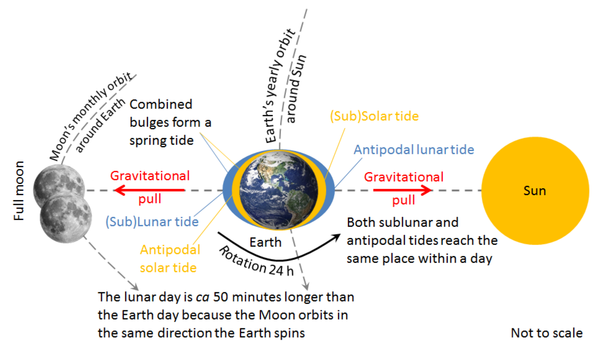
Adapted from: http://www.canaturalist.com/2016/01/23/bogus-terminology, https://manoa.hawaii.edu/exploringourfluidearth/physical/tides/tide-formation-and-gravitational-pull, https://www.flickr.com/photos/donkeyhotey/5679642883, http://www.thehoodwitch.com/blog/2017/3/11/full-moon-in-virgo-3122017.
- The Sun, Earth, and Moon form a line (a condition known as syzygy) and the Moon is in correct position (1 m).
- Solar and lunar tide bulges augment each other (coinciding) (called spring tide) (1 m).
- Subsolar tide and antipodal lunar tide and antipodal solar tide and sublunary tide are coinciding on opposite sides of the Earth (1 m).
- Earth’s anticlockwise rotation duration and orbit (0.5 m) and the Moon’s counter clockwise movement on its orbit (0.5 m).
- Annotations (explaining rotation durations and including labelling of Sun, Earth, full moon, (sub)solar tide, (sub)lunar tide and antipodal tides) (1 m).
3. Answer (point marking – 1 mark for each correct suggestion):
- These radical measures were launched because the unique characteristics of Mont Saint-Michel were being heavily degraded and France has international responsibilities to maintain the character of world heritage listed sites: the insular character during high tide that attracted tourists was being lost due to accumulating silt deposits. Due to increased siltation/silt deposits the castle was no longer surrounded/cut off by the sea at high tide which attracted tourists:
- The raised (permanently dry) causeway prevented the tide from scouring the silt around the mount. Replacement of the causeway with a bridge has restored the flow of water around the island.
- Land reclamation on coastal flats (polders) and grazed salt marsh meadows decreased the distance between the shore and the island allowing less and not so deep free water movement having less force to clean the area from disposed sediments.
- The canalized river reduced the spread of water (dispersion of the flow of water) to wash away accumulated silt from the (area). A hydraulic dam uses the waters of the river Couesnon and the tides to help remove the accumulated silt.
4. Answer (point marking – 1 mark for each correct suggestion):
Strengths – are internal characteristics of the project that give it an advantage over other projects
- Unlike some other renewable sources of power, tidal power is predictable.
- They can be constructed in areas where the coastal landforms mean that the old type of tidal power plant is not feasible.
- In areas vulnerable to flooding and coastal erosion, increasingly as a result of climate change, tidal lagoons can act as a barrier to potentially damaging and disruptive storm surges and waves that threaten coastal communities and infrastructure.
- Because it would be a landmark, it will be in instrumental in instigating/initiating regeneration and other developments.
- Renewable clean zero carbon (no during operation) year round cheap energy.
- Jobs in building and managing.
- It does not take land space because it is built on the water (no waste of arable land).
Weaknesses – are internal characteristics that are a disadvantage relative to other projects
- It is only feasible in areas with a high tidal range.
- Enormity of the project, high cost, procurement of right kind of building materials such as rocks, gravel and sand.
- As a first of its kind, none of the real impacts on environment, economy and socio-cultural life is known.
- The stability of the seawall is not strong enough to endure severe weather conditions.
- The understanding of coastal processes, of physical (e.g. influence on the currents) and biological origin may still have some blind spots.
- Although it is not standing water, it may need cleaning from algae.
- The fact that it is in a marine environment, makes it more difficult to deal with potential accidents (motor oil spills) or diseases, epidemics, e.g. bird flu.
- Difficulty of cleaning and repairing broken (corrosion?) turbines in the marine environment.
- Limits commercial shipping and navigation so may not get government approvals (meaning extra harbours need to be built on either side of the lagoon – instigating/initiating unplanned and unforeseen developments).
Opportunities – are external elements that the project could use to its advantage
- Increasingly stringent government regulations on greenhouse emissions favour clean energy.
- Society now expects new power plants will be non-polluting, favouring power plants such as the new type.
- Maximizing return on investment by developing associated aquaculture (lobster and oyster hatchery, edible seaweed, cockle and mussel farming and further development work around Integrated Multi-Trophic Aquaculture (IMTA) – a way of a number of different species living together for environmental and economic benefit), also creating new jobs.
- Establishing good relations with the local community by developing recreation (walks on the wall, cycling, running, playgrounds, sporting events, angling, swimming, canoeing, rowing and sailing), tourism, edutainment and environmental projects.
Threats – are external elements that could cause difficulties for the project
- A change in government policy could undermine the economic viability of the project.
- Changing self-regulatory environment to totally human-controlled environment can backfire on many unpredictable levels and scales.
- Severe weather conditions may damage the seawalls.
- Negative changes to the environment (such as to coastal processes, water quality, flooding and hydrology, intertidal and subtidal benthic ecology, fish, marine mammals, birds, terrestrial ecology, seascape and landscape, heritage, salinity, sedimentary deposits) may lead to government fines and loss of community goodwill.
- Natural hazards like earthquakes, tsunamis etc.
Notes page of the Marking Scheme
Notes
end ■
Оригинал в Архива: WRITTEN RESPONSE TEST QUESTION AND ANSWER BOOK.pdf · официални решения: WRITTEN RESPONSE TEST MARKING SCHEME.pdf