iGeo 2019, Писмен тест — Задача 3. Section C: Sand Dune Mobility and Desertification
16th International Geography Olympiad — Hong Kong — 30 July – 5 August 2019 — Written Response Test — Question and Answer Booklet · 30 юли 2019 г. · 15 т.
Внимание: Бележка към темата
The Resource Booklet (Figures A1–F2, Tables C1 and E1 and the Section C instructions) referred to in the questions is not part of this archive file.
Корица
Do NOT open the Booklet before instructed to do so by a supervisor.
Name: … Team: …
iGeo student number: …
Instructions for Students
Fill in your name, team and iGeo student number on the front page of this Question and Answer Booklet.
Fill in your iGeo student number in the boxes on top of each of the pages in this Booklet.
This test consists of 6 Sections.
The maximum total mark is 90. The mark for each question is given in the margin at the beginning of the question.
There is a maximum of 15 marks for each Section.Answer all questions in the spaces provided in this Booklet in English. Keep the left margin free for markers.
Please write clearly.
Please use blue (or black) pen, not pencil.
Check the backs of pages as questions are written on both sides.There are blank pages which you can use as additional space for your notes. Please cross through any notes so that we know they are not part of your answers.
If you use these pages for answers, please label them clearly with the Section and question number (e.g. A1).Where appropriate, please write sentences or phrases not single words.
Give only the required number of answers (reasons, examples, etc.). For instance, if the question asks for 2 reasons and you give more than 2, only the first 2 reasons will be marked.
The Resource Booklet contains Figures referred to in this Booklet. Do not write any of your answers in Resource Booklet.
You may use a calculator during the test.
Students not educated in English are allowed to use bilingual dictionaries during the test.
Time: 180 minutes for students not educated in English (+10 minutes reading time),
150 minutes for students educated in English (+10 minutes reading time).
Good luck!
Written Response Test
Contributions from: Australia, China Taipei, Romania
Committee Convenor: Dubravka Spevec (Croatia)
Deputy: Mark Higginbottom (UK)
Director of Tests: Sue Lomas (UK)
Instructions for Markers
Check if the iGeo student numbers are on each sheet before dividing up the Test.
This test consists of 6 Sections.
The maximum total mark is 90. The mark for each question is given in the margin at the beginning of the question.
There is a maximum of 15 marks for each Section.One whole Section per (at least) one pair of markers.
Get the hang of the full range of answers by reading through a few papers with your co-marker before you start your marking. You can mark together (especially for level marking), or after establishing a consensus on how to mark for thoroughness and consistency, act as each other’s double-checkers by marking half of the test and then swapping the pile.
We strongly recommend whenever in doubt, consult your marking partner and, if appropriate, one of the designated Moderators – Dubravka or Mark.Please develop your own marking/correcting notation system (using +/-, x/0, √ marks), underlining, comments etc. to ease double-checking and sample marking.
These answers here are not exhaustive. Credit any relevant answer.
Check whether the answer continues outside the designated area, in the margins or as clearly marked on blank pages. No credits will be given to answers in the Resource Booklet.
The Test uses two marking systems: point and level marking.
Half marks can only be given where indicated as the total of 90 marks will yield only 40% of the total Olympiad result.
Mark only the required number of answers (reasons, examples etc.). For instance, if the question asks for 2 reasons and there is more than 2, only the first 2 reasons should be marked.
Put your final mark next to the question number in the column on the left – it eases the work of the person who has to put the numbers into MS Excel. Please write your numbers clearly.
Please write down any inconsistencies of the Marking Scheme, revisions and additional answers or answers not accepted on the Notes page at the end of the Booklet (e-mail is preferred) and hand them in after marking to improve the final Marking Scheme that will be uploaded to show the actual marking.
The Moderators (Dubravka and Mark) will sample the marking of all teams.
Command Terms for use in Written Response Test
| Terms | Meaning |
|---|---|
| Assess | make a judgment on the significance, relevance, value or quality of something by carefully weighing the advantages and disadvantages, the positive and negative features |
| Describe | give a factual statement of the distinctive features of something, e.g. for a landform, its shape, dimensions, composition, location (do not explain) |
| Discuss | give a thorough account from different points of view |
| Draw | make a clearly defined diagram, flowchart or map, and include labels |
| Evaluate | consider several arguments or options and come to a conclusion about their importance or success |
| Explain | give a reason, a cause, an effect, a consequence for why or how something happens |
| Identify | name, select, point out something |
| List | identify or name a number of specific things |
| Name | state or specify, using a word or words by which something is known |
| Outline | give the main points or general principles of something, omitting minor details, and usually emphasizing structure and relationships |
| Suggest | put forward an idea or a reason |
In level marking in order to credit higher marks the response has to cover a multi-perspective view with a range of factors/impacts from different spatial and temporal scales forming a thorough and well-elaborated account.
Written Response Test
Contributions from: Australia, China Taipei, Romania
Committee Convenor: Dubravka Spevec (Croatia)
Deputy: Mark Higginbottom (UK)
Director of Tests: Sue Lomas (UK)
Условие
1. Study Resource Booklet Figure C1: Satellite image of sand dunes in the Arabian Desert.
What is the direction of the prevailing wind in this area? [1 т.]
2. Name 2 natural factors that influence sand dune mobility. [1 т.]
3. Following the Instructions in the Resource Booklet Section C, draw a triangulated irregular network on the map below.
Inside this network draw contour lines of the P/PE values from the Resource Booklet Table C1: Values of dune mobility index (M) and dune activity codes (with the contour interval 0.1) for the 12 Weather Monitoring Sites. [9 т.]
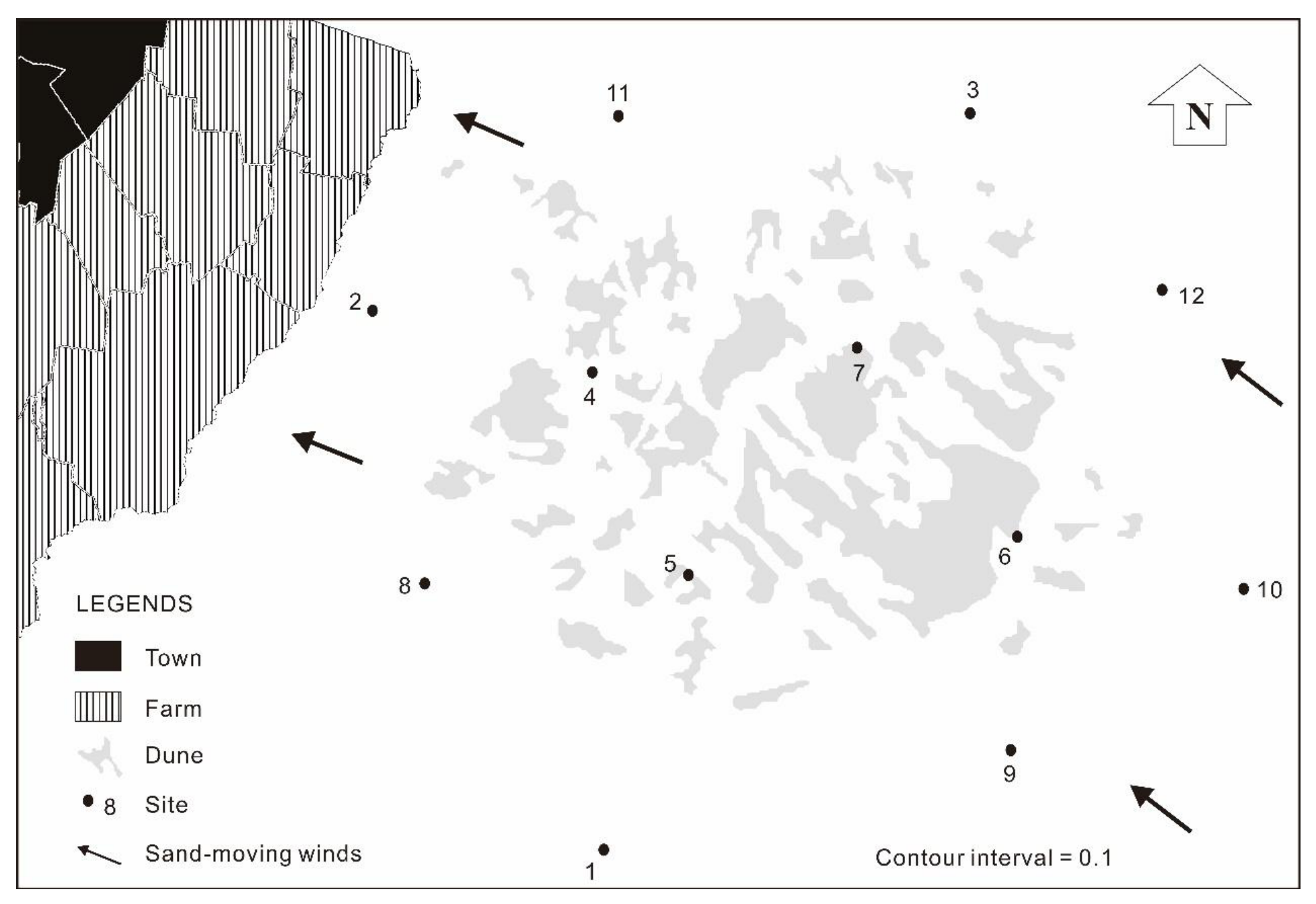
4. Which Weather Monitoring Sites have relatively high desertification threats? [1 т.]
5. Suggest strategies for the local farmers and the government that could prevent the threats of desertification. [3 т.]
Отговори
- 1. from North to South / NW-SE / NE-SW (or from top to bottom)
- 4. North-northeastern area (or Site 3 area); Western area (or Sites 2 and 8 area)
Решение
1. (1m)
Answer (point marking – 1 mark for correctly named direction):
- from North to South / NW-SE / NE-SW (or from top to bottom)
2. (1m)
Answer (point marking – 0.5 marks for each correct factor):
- wind (degree of windiness, wind velocity)
- rain efficiency (the amount of precipitation and potential evaporation)
- sand grain size
- relief barriers
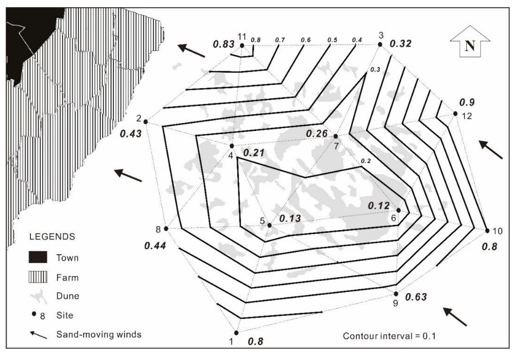
3. (9m)
Answer (point marking)
(1) 1 mark for correctly marking the P/PE values of the sites on the map.
(2) 3 marks for correctly drawing the triangulated irregular network.
(3) 4 marks for reasonably drawing the contour lines of P/PE.
(4) 1 mark for marking the value of contour line.
4. (1m)
Answer (point marking – 0.5 marks for each correctly identified area):
- North-northeastern area (or Site 3 area)
- Western area (or Sites 2 and 8 area)
5. (3m)
Answer (point marking – students who provide relevant and reasonable answers can get marks. If students write only one strategy but in more details – as in the marking scheme below, they could have 2 marks for it):
(1) Securitizing productive land - securing peace and stability
Sustainable land use practices: Over 250 sustainable land management (SLM) techniques that, at once, combat land degradation and build its resilience to drought and climate change are available through the Convention alone. Land users in China, for instance, have access to over 1,000 SLM practices. SLM methods are cheap, but durable. With the right incentives, they can be disseminated widely and rapidly to land users, including communities like those in Bangalala.
(2) Investing in large-scale restoration initiatives
The climatic effects on land occur at ecosystem and landscape levels. Therefore, individual and community efforts to rehabilitate the land are at their most effective when they are part of a country-wide or regional-level effort to preserve and rehabilitate landscapes. Large-scale interventions provide multiple benefits that go beyond national and regional levels.
(3) Drought-management measures
Drylands are prone to drought and desertification, but they are vital for global food security today and harbor valuable plant and animal species that are essential for humanity’s adaptation and resilience to climate change. Drought impacts are most visible in human losses and on agricultural production, but have higher knock-on effects on other economic sectors. Droughts do not have to kill, lead to displacement or forced migration, even in drylands. Setting up national and regional drought policies would enable countries and regions to preempt their impacts, respond to crises and manage droughts effectively. Voluntary co-contributory insurance schemes and risk transfer mechanisms designed for communities in drought-prone areas need to be part of these efforts. Drought relief may be rewarding poor resource managers and punishing proactive planners that lack support mechanisms.
(4) Institutional reforms
Smart incentives are needed to change current practices in areas vulnerable to desertification and drought by: discouraging land use practices that degrade the land; accelerating the adoption of sustainable land use practices and drought planning; harmonizing action and aligning policies across ministries and agencies with land mandates; strengthening and simplifying the rights to land and investments in natural resources; and strengthening drought policies and climate adaptation and resilience mechanisms.
Notes page
This page is intentionally blank (you can use it for your notes (please cross them through afterwards) or for answers, which are clearly labelled with the Section and question number).
Оригинал в Архива: 2019WRT_QA_Booklet.pdf · официални решения: 2019WRT_Marking_Scheme.pdf