IOAA 2015, Отборен тур — Задача 1. TEAM COMPETITION PROBLEM
TEAM COMPETITION PROBLEM
Внимание: Бележка към темата
The related official keys supply the shared measurement method and five example station results, but not the final July31 task’s requested constellation drawings at 18:00 and 19:00 or complete results for all stations. The alternate English DOCX instead asks for nearby celestial objects at18:00; its wording is not substituted into this edition.
Условие
The Borobudur Temple, built in the 9th century, is the biggest Buddhist temple in the world built of stone. It is considered to be one of the wonders of the ancient world. It has nine stacked platforms. The first six platforms have a square form and beautifully decorated with numerous reliefs. The upper three platforms are circular, with 72 small bell-shaped stupas, surrounding one large central stupa (main stupa). The altitude of the ground close to the entrance is 265 m above mean sea level. Note that the height of the temple is 35 m (measured from the top of the main stupa to the ground).
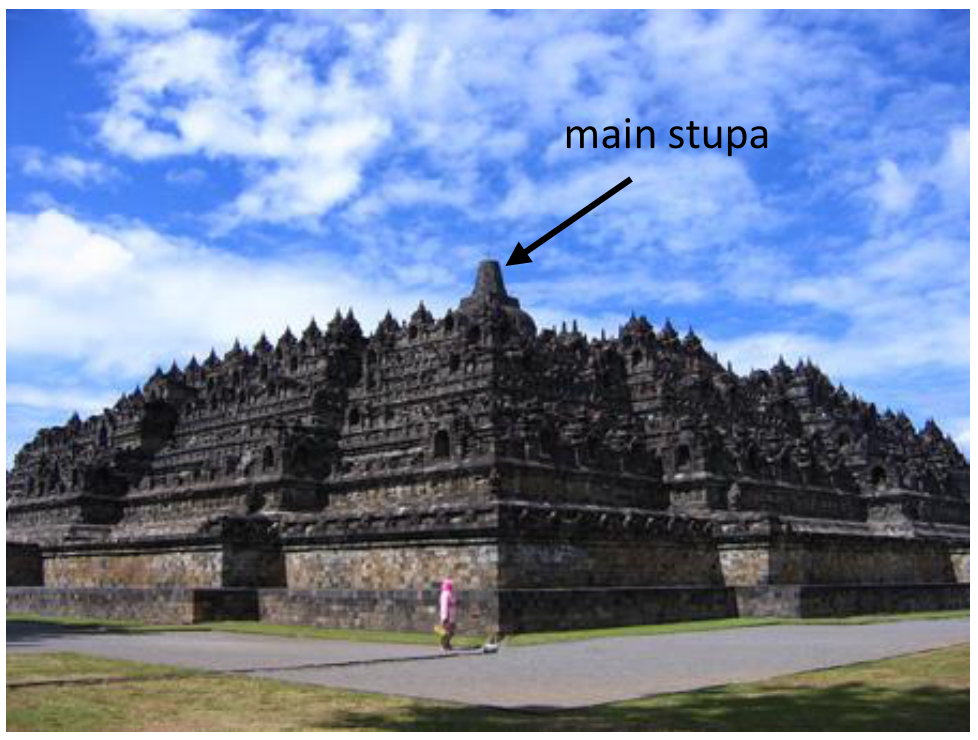
Observing stations
We believe that the constructors of this temple had quite a good knowledge of astronomy. In search of the possible existence of the astronomical alignment between Borobudur and any celestial bodies, we will make some measurements. Observers are distributed around the temple, mainly on the eastern and western sides. The observing station number card (placed on the table) specifies the exact latitude and longitude for that station. Example coordinates for some stations are given in the table below.
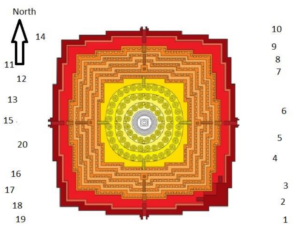
Table 1: Example Coordinates of observer’s positions
| Position | longitude | latitude | Altitude (m) |
|---|---|---|---|
| 1 | 110° 12′ 16.52″ | -7° 36′ 30.10″ | 264 |
| 2 | 110° 12′ 16.69″ | -7° 36′ 29.80″ | 264 |
| 3 | 110° 12′ 16.82″ | -7° 36′ 29.62″ | 264 |
| 4 | 110° 12′ 16.65″ | -7° 36′ 28.85″ | 265 |
| 5 | 110° 12′ 16.54″ | -7° 36′ 28.26″ | 264 |
Tasks
From your position, if you observe the sky in the direction of the top of the main stupa (not of the top of the lightning rod), determine:
a. If you observed at 18:00 (UTC+7), what constellation would align with the main stupa?
b. Draw the constellations you expect to see from your position in the direction of the stupa at 18:00 and 19:00 (UTC+7).
Note: assume compass points to the true north
You are provided with:
- Planisphere
- Magnetic compass
- Protractor, string, and a weight
Describe your answer thoroughly.
Решение
Внимание: Непълно решение
The related official keys supply the shared measurement method and five example station results, but not the final July31 task’s requested constellation drawings at 18:00 and 19:00 or complete results for all stations.
Solution
The position of the observer is given after being determined using GPS: longitude, latitude, and altitude. In fact, only latitude is necessary in the analysis. We have two spatial points (observer position and reference point/peak of main stupa), so we can use the classical formula to calculate the declination of celestial bodies, that is,
in order to determine the alignment direction.
Thus, students should :
a) determine azimuth of the object using a magnetic compass (assuming that it points to the true north);
b) determine the elevation angle between their position and the peak of the stupa using protractor and a weighted string;
c) determine the declination using the measured parameters;
d) identify the constellation using provided star chart based on the results a-c, assuming that the observations are performed at 18:00.
See Table below.
| Position | longitude | latitude | Altitude (m) | lat | h (deg) | arc sin δ | Constellation | Object | ||
|---|---|---|---|---|---|---|---|---|---|---|
| 1 | 110° 12′ 16.52″ | -7° 36′ 30.10″ | 264 | -7.6083611 | 21.5 | 74.5 | 0.19793 | 11.41588681 | Leo | Regulus |
| 2 | 110° 12′ 16.69″ | -7° 36′ 29.80″ | 264 | -7.6082778 | 22 | 98 | -0.1775 | -10.22422264 | Hydra | |
| 3 | 110° 12′ 16.82″ | -7° 36′ 29.62″ | 264 | -7.6082278 | 20.5 | 45.5 | 0.60438 | 37.18391917 | Leo Minor | |
| 4 | 110° 12′ 16.65″ | -7° 36′ 28.85″ | 265 | -7.6080139 | 22 | 62.5 | 0.37476 | 22.00954381 | Leo | gamma-Leo |
| 5 | 110° 12′ 16.54″ | -7° 36′ 28.26″ | 264 | -7.60785 | 19.5 | 135.5 | -0.71061 | -45.28493973 | Vela |
(This is an example only)
Example of panel.
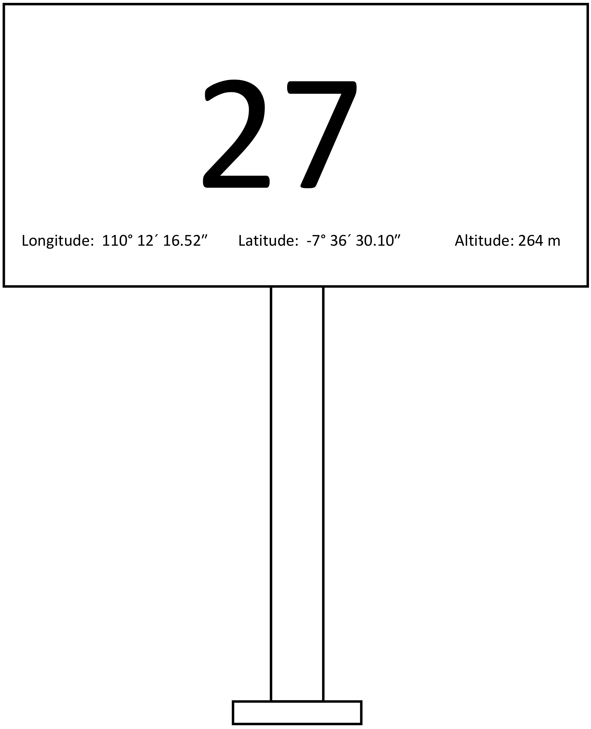
Solution to Team Competition
| Position | longitude | latitude | Altitude (m) | lat | h (deg) | arc sin δ | Constellation | Object | ||
|---|---|---|---|---|---|---|---|---|---|---|
| 1 | 110° 12′ 16.52″ | -7° 36′ 30.10″ | 264 | -7.60836111 | 21.5 | 74.5 | 0.197929 | 11.41588681 | Leo | Regulus |
| 2 | 110° 12′ 16.69″ | -7° 36′ 29.80″ | 264 | -7.60827778 | 22 | 98 | -0.1775 | -10.22422264 | Hydra | |
| 3 | 110° 12′ 16.82″ | -7° 36′ 29.62″ | 264 | -7.60822778 | 20.5 | 45.5 | 0.604376 | 37.183191917 | Leo Minor | |
| 4 | 110° 12′ 16.65″ | -7° 36′ 28.85″ | 265 | -7.60801389 | 22 | 62.5 | 0.374761 | 22.00954381 | Leo | gamma-Leo |
| 5 | 110° 12′ 16.54″ | -7° 36′ 28.26″ | 264 | -7.60785 | 19.5 | 135.5 | -0.71061 | $ (45.28) | Vela | |
| 6 | ||||||||||
| 7 | ||||||||||
| 8 | ||||||||||
| 9 | ||||||||||
| 10 | ||||||||||
| 11 | ||||||||||
| 12 | ||||||||||
| 13 | ||||||||||
| 14 | ||||||||||
| 15 |
Catatan:
- Lengkapi tabel ini dengan entry data lokasi pengamat yang diukur dengan GPS (45 lokasi)
- Masukkan hasil pengukuran sudut elevasi dan Azimuth
- Hitung deklinasi dengan rumus yang sudah diberikan
- Gunakan peta bintang untuk menentukan rasi dan obyek yang terkait
Оригинал в Архива: Team Competion Problem 20150731.pdf · официални решения: Team-Competition-Solution.pdf · допълнителни данни: Team_Solution.pdf · допълнителни данни: TeamProblem_EN.docx