IOAA 2019, Теория — Задача 10. South → East → North
Theory problem sheet · 20 т.
Условие
Consider the Earth as a perfect, rigid, sphere with radius . There exist some points on the surface of the Earth from which we can travel first 6378 km South, then 6378 km East, and after that 6378 km North, and as a result return to the original point of departure. Find such points and paths. Calculate the geographic coordinates of the turning points of your solutions and draw the paths.
For the sake of simplicity measure the geographic longitude from to eastward from Greenwich, the geographic latitude from to north of the Equator and from to south of the Equator. Solutions resulting from rotational symmetry should not be considered to be different.
Решение
1.
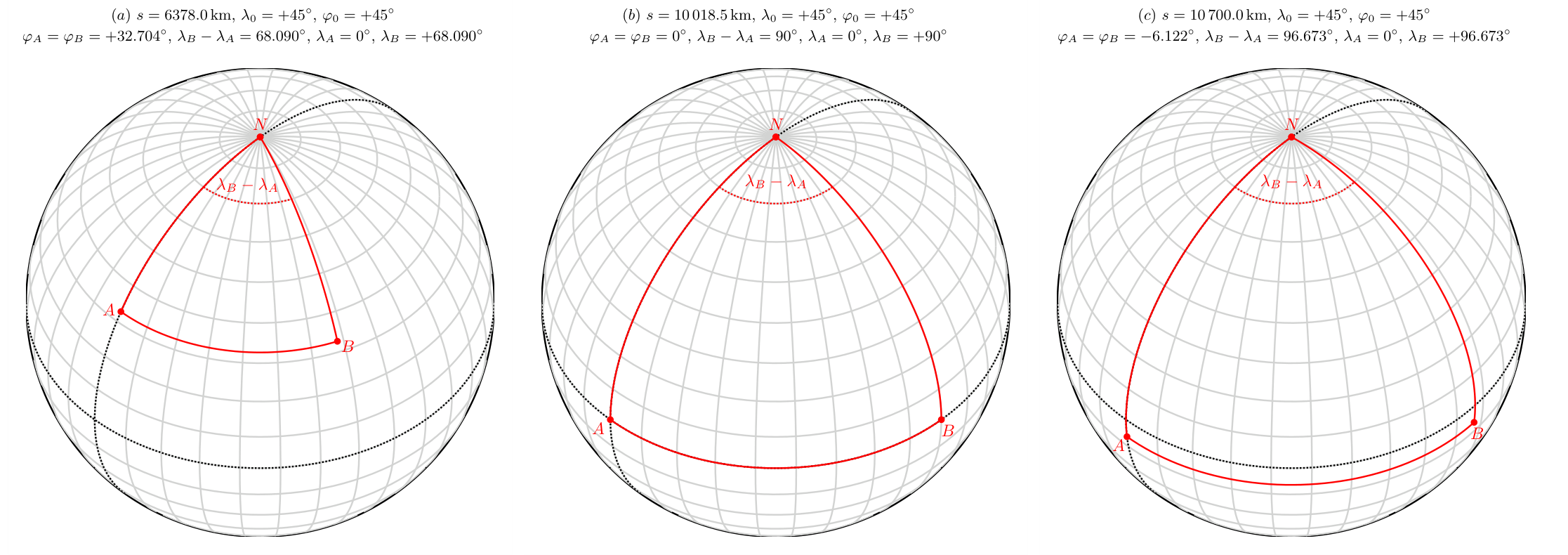
The trivial solution of the problem is the North Pole (). Starting from here we travel 6378 km to the South () along a meridian (e.g. Greenwich meridian), then 6378 km to the East along a parallel (), and finally 6378 km to the North () (see figure (), where the black dashed lines are the Equator and the Greenwich meridian).
For the general solution, mark the path to be taken in one direction with and determine what it may be!
Let us denote the longitude and latitude of the point by and , and the point by and .
The triangle is a spherical one only if the points and are on the Equator (see figure ()), i.e. and , because the arc is lying along a great circle only in this case, otherwise it is a part of a parallel. The point and can be below the Equator as well (figure ()).
Next, we measure the angles in radians.
The central angle of the arc on the meridian fitting to the point ( is the centre of the sphere):
Thus the length of the arc :
The radius of the latitude circle fitting to the points and :
The central angle of the arc is , thus the length of the arc :
From the Eq. (10.2) and Eq. (10.4):
Substitute the expression of from the first equation into the second equation:
For a given arc length of () the latitude of the points and , and the difference between their longitudes we can calculate from the following equations:
***** Supplement. It is just for the sake of completeness, not necessary for the full marks.
It is well known, that
thus in case of .
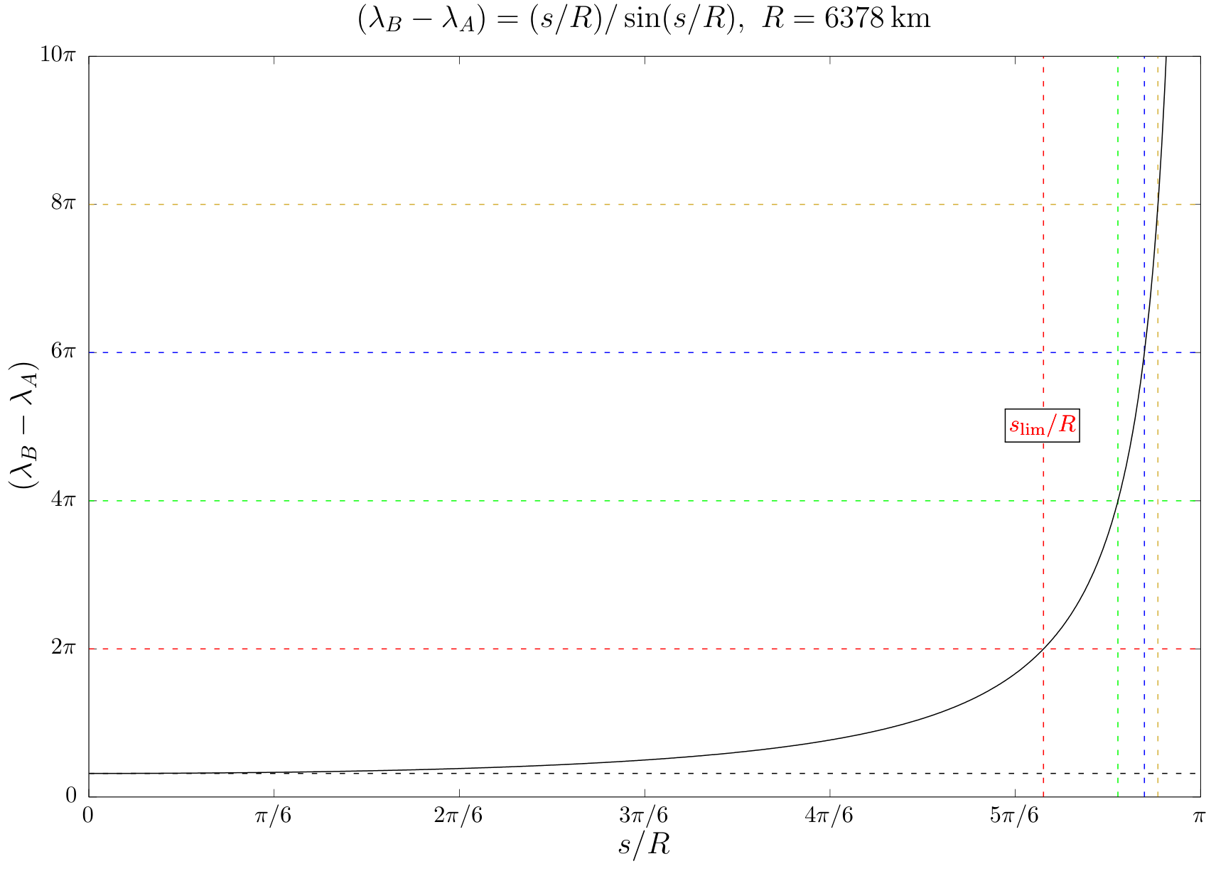
Therefore the difference in longitude has a lower limit (1), but it has no upper limit. This means, that the distance between the points and will increase by increasing , the difference between their longitudes will approximate (see figure ()), and in case of the points and will be the same (see figure ()). With further increasing of the difference will be larger than (see figure ()), thus we have to stop at that point on the circle where the length of the path along it reaches the value of , and then turn to the North.
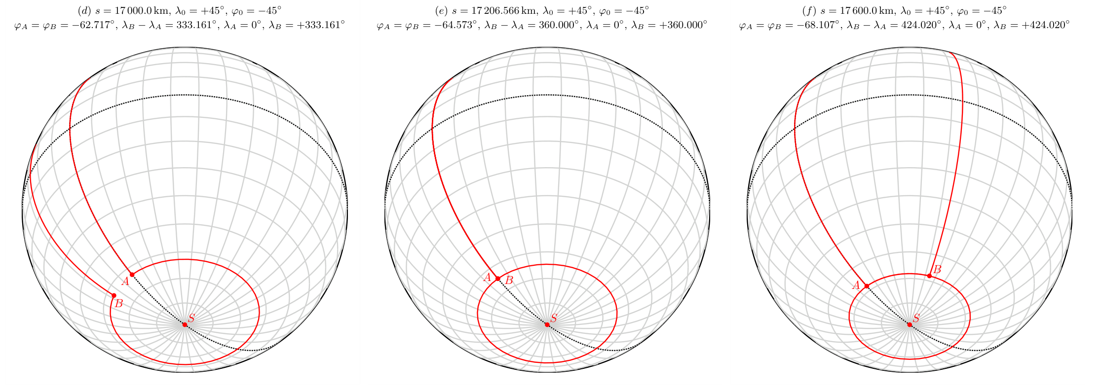
The arc length corresponding to the "limit case" of we can derive from the numerical solution of the following transcendent equation:
Thus find the root of the function
i.e. the value , where . We can solve it by iteration using e.g. the Newton–Raphson method:
The first derivative of the function :
We know that the parallel in question runs south from the Equator, thus a good initial value for the iteration could be , where km.
The result of the iteration and the corresponding latitude with three decimal places:
is strictly increasing function of and
thus for any values of can be found an appropriate angle (see the figure below).
***** End of supplement.
In conclusion, the solution in this case is the North Pole (). [2 p]
For the value of km the solution is an ()-type curve. The coordinates of the turning points are:
[3 p]
2.
The non-trivial solutions are similar to the ()-type ("lasso") solution of the previous part, only the starting point is not the North Pole, but its location depends on the given value of arc length . The circle of the lasso will run south from the ()-type "limit circle", because the circumference of parallels running north from it are greater than the north-south arc.
The procedure is the following.
Knowing , we have to find the parallel around the South Pole (), whose circumference is an integer multiple of . [2 p]
If the corresponding latitude is , then:
[5 p]
If the latitude of the sought starting point is , then the length of the arc to be taken along the meridian:
From the Eqs. (10.10) and (10.11):
Thus:
[2 p]
and
[2 p]
The negative sign denotes that the parallel is in the southern hemisphere.
So if the starting point is not the North Pole (), there are infinitely many solutions.
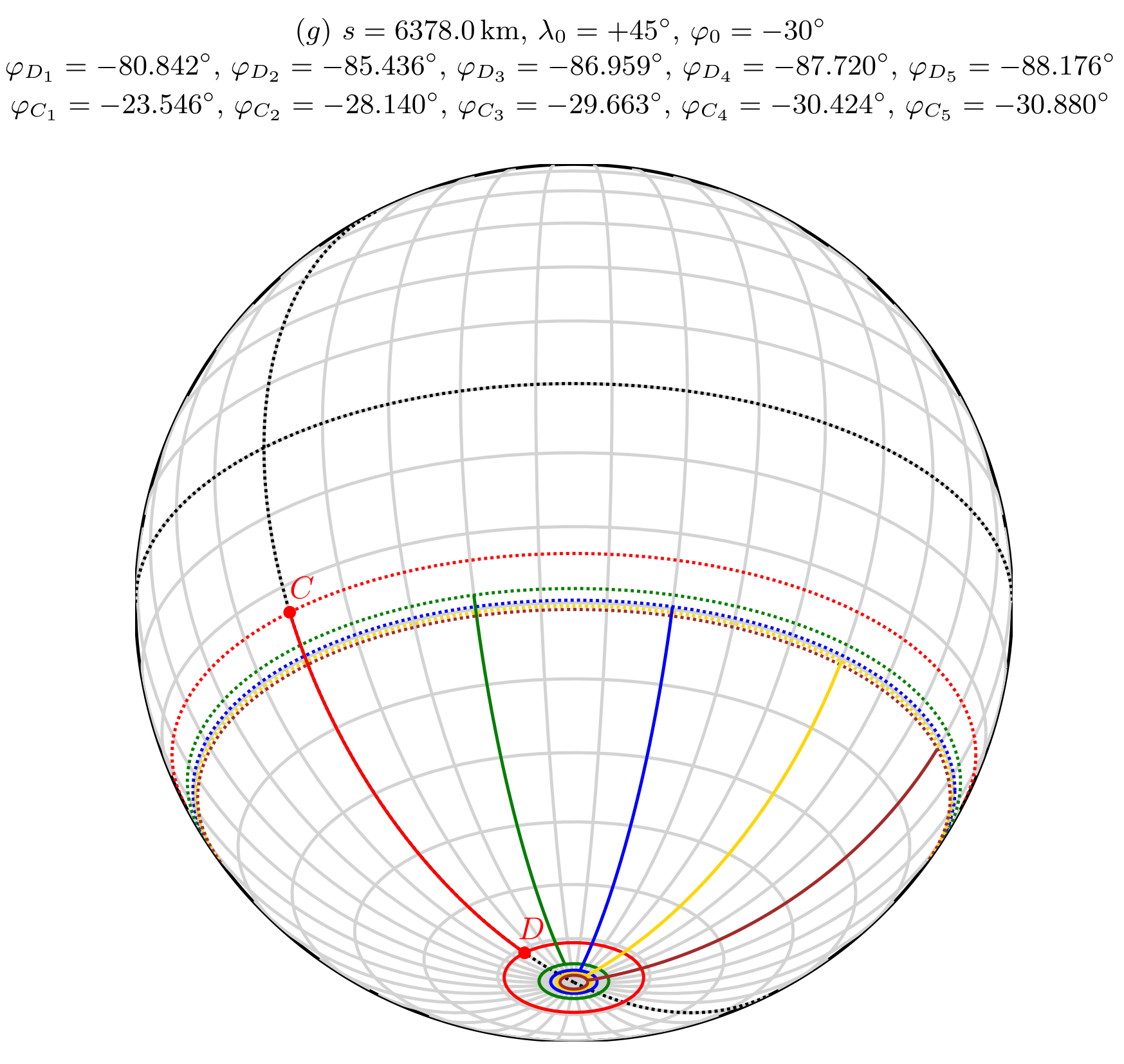
For the value of km the first 5 () value for in degrees with 3 decimal places:
[2 p]
The first 5 () value for in degrees with 3 decimal places:
[2 p]
In conclusion, starting to the South from a point of the parallel marked with a dashed red line (), we get to a point on a parallel marked with a continuous red line (). On this parallel we travel a full circle to the East, then we get back to the point , then turn to North and travel back to starting point .
For the further values of the procedure is very similar, but we have to perform two full circles along the continuous green parallel, three along the blue, four along the gold, five along the brown and so on.
Such kind of solution exists for any values of .
Оригинал в Архива: TH-problem-final.pdf · официални решения: TH-solution-final.pdf · допълнителни данни: TH-anssheet.pdf