iGeo 2006, Теренна работа — Задача 4. Question 4
6th International Geography Olympiad, Brisbane, Australia. Fieldwork Test · 30 юни 2006 г. · 5 т.
Fieldwork Test. Part A — Question Booklet
Friday 30 June 2.00 - 3.15pm
You may have with you stationery items, a calculator, a language dictionary, and your annotated map and notes from this morning’s fieldwork.
Answer the questions in the answer booklet provided
Fieldwork Test. Part B — Question Booklet
Saturday 1 July 9.00 - 10.30am
You may have with you stationery items, a calculator, a language dictionary, your Answer Booklet from Part A, the aerial photo distributed during the fieldwork, your annotated map and notes from this morning’s fieldwork.
Answer the questions in the answer booklet provided
(Question 1 and 2 were in Part A)
Условие
(5 marks - approximately 100 words, in point form or in sentences)
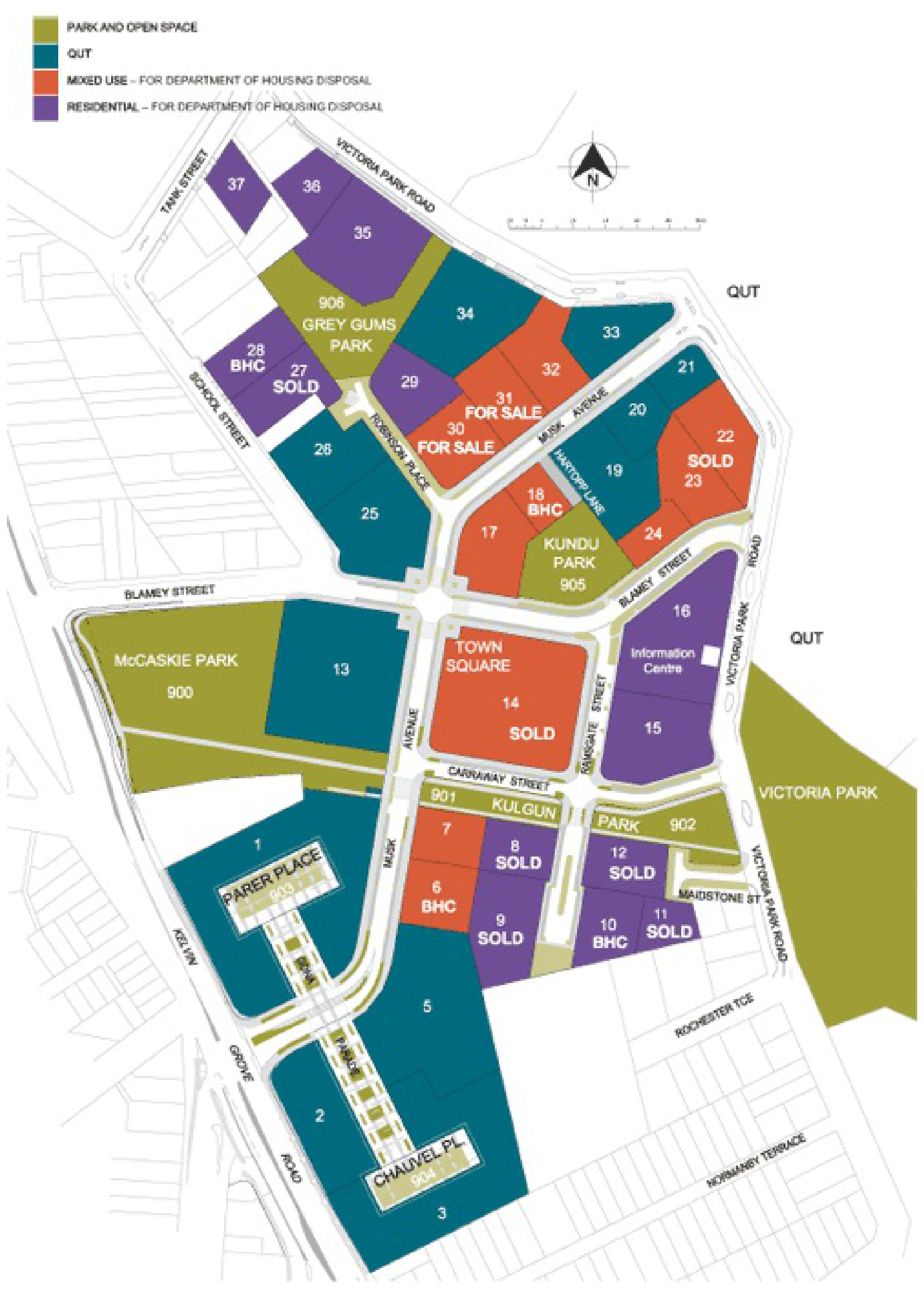
Describe how the current land uses shown in your completed map from Question 1, and the planned land uses shown in the map on the next page, are distributed across the Kelvin Grove Urban Village site.
Explain the distribution of these land uses. Use at least 3 influencing factors in your answer.
[In the test students received a high resolution printed copy of this map]
Решение
Question 4 - Map Analysis - 5 Marks
Description of distribution of land uses - 4 valid points for 2 marks
Examples of points
- There are a variety of land uses
- Village centre is at the centre of the hub
- Mixed use is along the main street (Musk Street)
- There are designated residential areas on the outer sections of the village and on the upper floors of mixed use buildings
- Parks and open spaces are distributed throughout
- Considerable university land use in the creative arts precinct
- The large amount of vacant space indicates future development
Explain the distribution of these land uses - at least 3 valid factors for 3 marks
Examples
Based on walking (you can live without a car)
A variety of land uses where everything is in walking distance, e.g. shops, restaurants, school, supermarkets
Access to public transport
Mixed tenure - Premises may be owned, leased or rented and this provides for a variety of life styles and age groups, e.g. student accommodation, public housing, managed senior accommodation
Mixed use / high density
In the centre there are multi-storey buildings with commercial/retail uses on the ground floors and residential predominantly on the upper floors
Encourage residents to live, work and shop in the village
Sense of neighbourhood
Residential areas are clustered together
Parks and open spaces encourage people to go out and play or meet people
Shop fronts face the main street and this promotes the idea of a village
All residential areas are away from the main road (Kelvin Grove Road)
Students may use the following terms to explain the distribution:
- Environmental/ecological
- Social sustainability
- Economic
Оригинал в Архива: 2006FWtest.pdf · официални решения: 2006FWmarkingscheme.pdf